Weak La Niña forms in Pacific Ocean, here's what it means
Meteorologist/Science Writer
Thursday, November 10, 2016, 1:16 PM - After months of speculation, La Niña has officially arrived. (What is La Niña?)
It's weak, certainly no match to the record El Niño that was in place just about a year ago, but La Niña is there, it appears solid and is likely to persist throughout the northern hemisphere winter. (What is El Niño?)
That's the word from the U.S. National Oceanic and Atmospheric Administration (NOAA), which monitors conditions across and above the Pacific Ocean for the development of El Niño and La Niña patterns.
"A weak La Niña is in place and is likely to remain for the winter," said Mike Halpert, deputy director, NOAA’s Climate Prediction Center, according to the agency's ENSO blog. "The weak La Niña is likely to contribute to persisting or developing drought across much of the southern U.S. this winter."

Three-month running average sea surface temperature anomalies for the central equatorial pacific (the Niño 3.4 region) - also known as the Oceanic Niño Index - denote La Niña conditions for the July-August-September (JAS) and August-September-October (ASO) periods. Credit: NOAA CPC
Although NOAA typically requires five consecutive 3-month running averages to be below the -0.5oC threshold to officially call a La Niña, it appears as though the consistent nature of the pattern, along with the fact that it appears to be short-lived (only lasting through until February), has led to the forecasters to declare the La Niña now.
Waiting the normal amount of time would have them calling it just as it is expected to dissipate.

This animation of sea surface temperature anomalies reveals the regions of the Pacific Ocean that are above or below normal temperatures for this time of year. Note the expanding streak of cooler than normal temperatures (blue) across the equatorial Pacific, that denotes the development of this La Niña. Credit: NOAA CPC
![]() RELATED: What is La Nina?
RELATED: What is La Nina?
When moderate or strong La Niña conditions develop, it usually means a colder winter for the western half of Canada, which can even impinge on Ontario as well, at times, and there's typically wetter conditions in the U.S. northwest and BC's south coast, and near the Great Lakes.
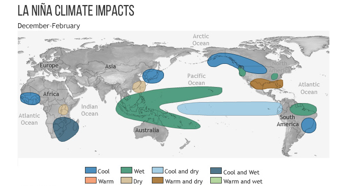
Typical impacts of La Niña on the world during Northern Hemisphere winter. Credit: Climate.gov
With this being a weak La Niña, however, and expected to remain weak, it's unlikely that Canada will see any significant widespread impacts over Winter 2016/2017.
What it may do, though, is influence exactly where we have the most active weather during the coming season, based on the typical pattern of the jet stream during a La Niña episode.
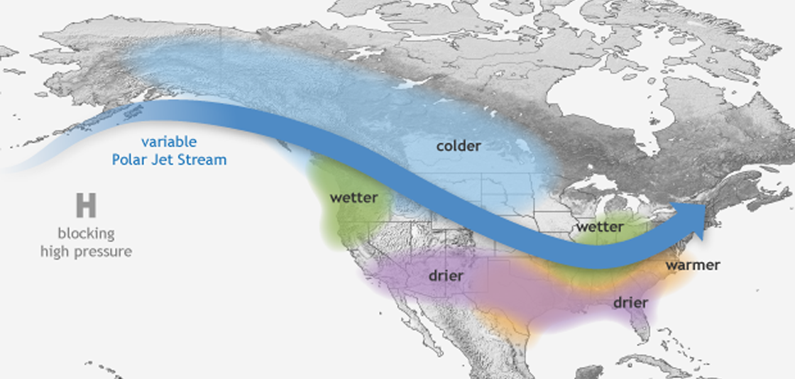
Credit: NOAA
We will continue to post updates on this pattern as it develops.
Teaser image courtesy NOAA


