Cold Canadian air fuels volatile fall weather in the south
Meteorologist, PhD
Thursday, September 22, 2016, 1:49 PM - A rapidly developing supercell thunderstorm spawning a tornado, an unexpected snowfall or even a rapidly advancing wild fire, are just examples of fall surprises.
![]() FALL IS BACK: After a hot summer what can Americans expect from fall? Find out with The Weather Network’s 2016 Fall Forecast | FORECAST & MAPS HERE
FALL IS BACK: After a hot summer what can Americans expect from fall? Find out with The Weather Network’s 2016 Fall Forecast | FORECAST & MAPS HERE
Sharp temperature or humidity changes from one day to the next are common during fall across many areas, but the main concern for many is how those abrupt oscillations can eventually lead to a hazardous situation.
U.S. Tornado Season still alive and kicking during the Fall
Unlike the defined hurricane season in the U.S., tornados can occur all year and means there is no actual tornado season. However, different regions experience a different tornado frequency, depending on the time of year.
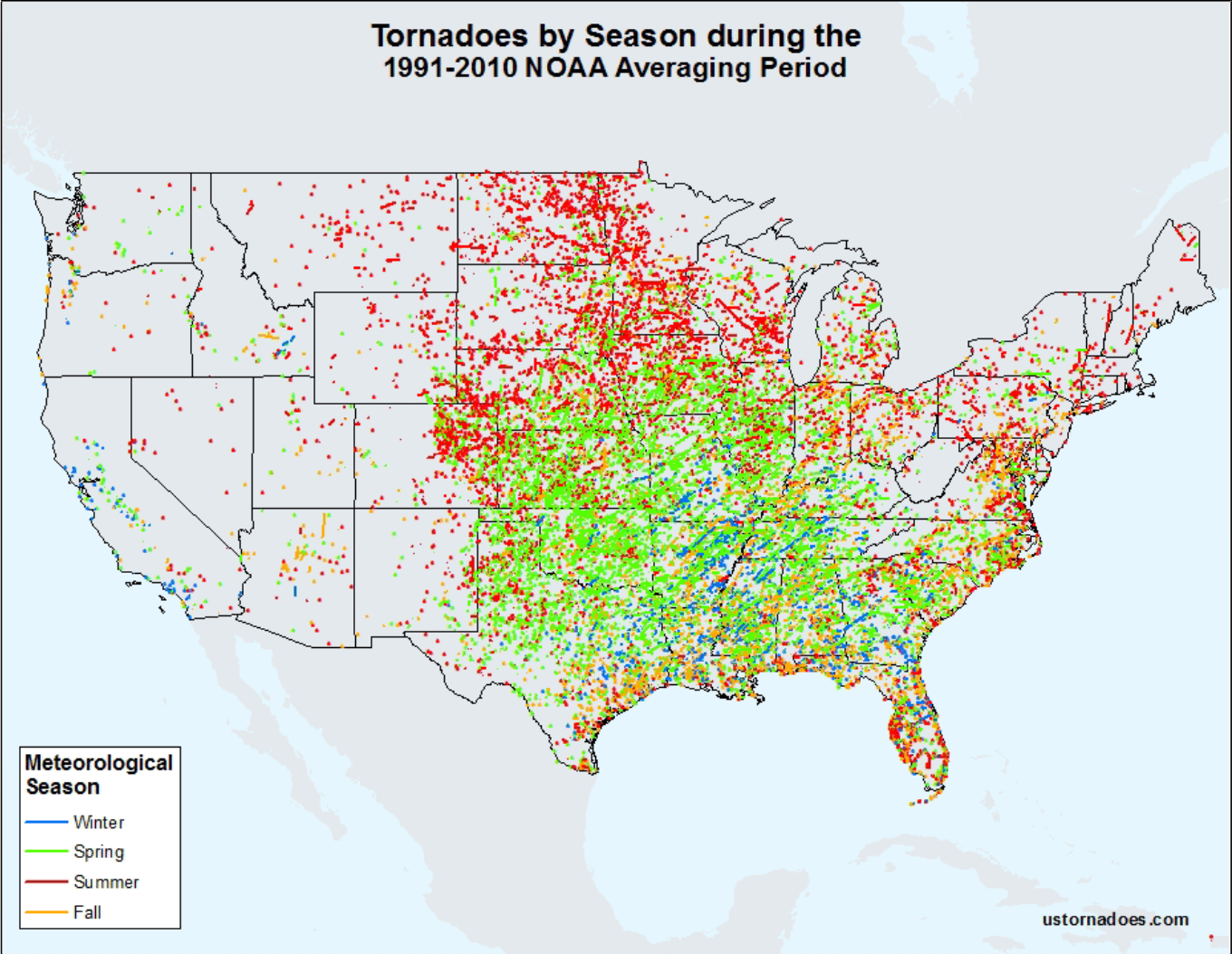
We know the spring months are usually the most active in term of tornado occurrence across many states followed by summer. But fall is also a fairly active time of the year for tornado formation, with some of the strongest twisters first moving across sections of the Upper Midwest and Ohio River Valleys, and later in the season along other sections of the south and southeast.
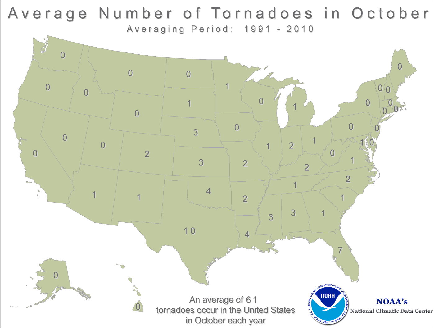
Average tornadoes for October (via NOAA):
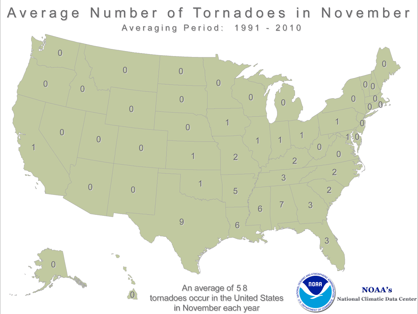
Average tornadoes for November (via NOAA):
The main reason for this late year peak in the frequency of tornadoes is mostly linked to the first incursions of cold Canadian air flowing south as early as September. When these early cold air masses collide with the very warm moist air flowing north from an overheated Gulf of Mexico, an explosion occurs in the atmosphere and very large rotating supercell thunderstorms form.
![]() What is La Niña? | What is El Niño?
What is La Niña? | What is El Niño?
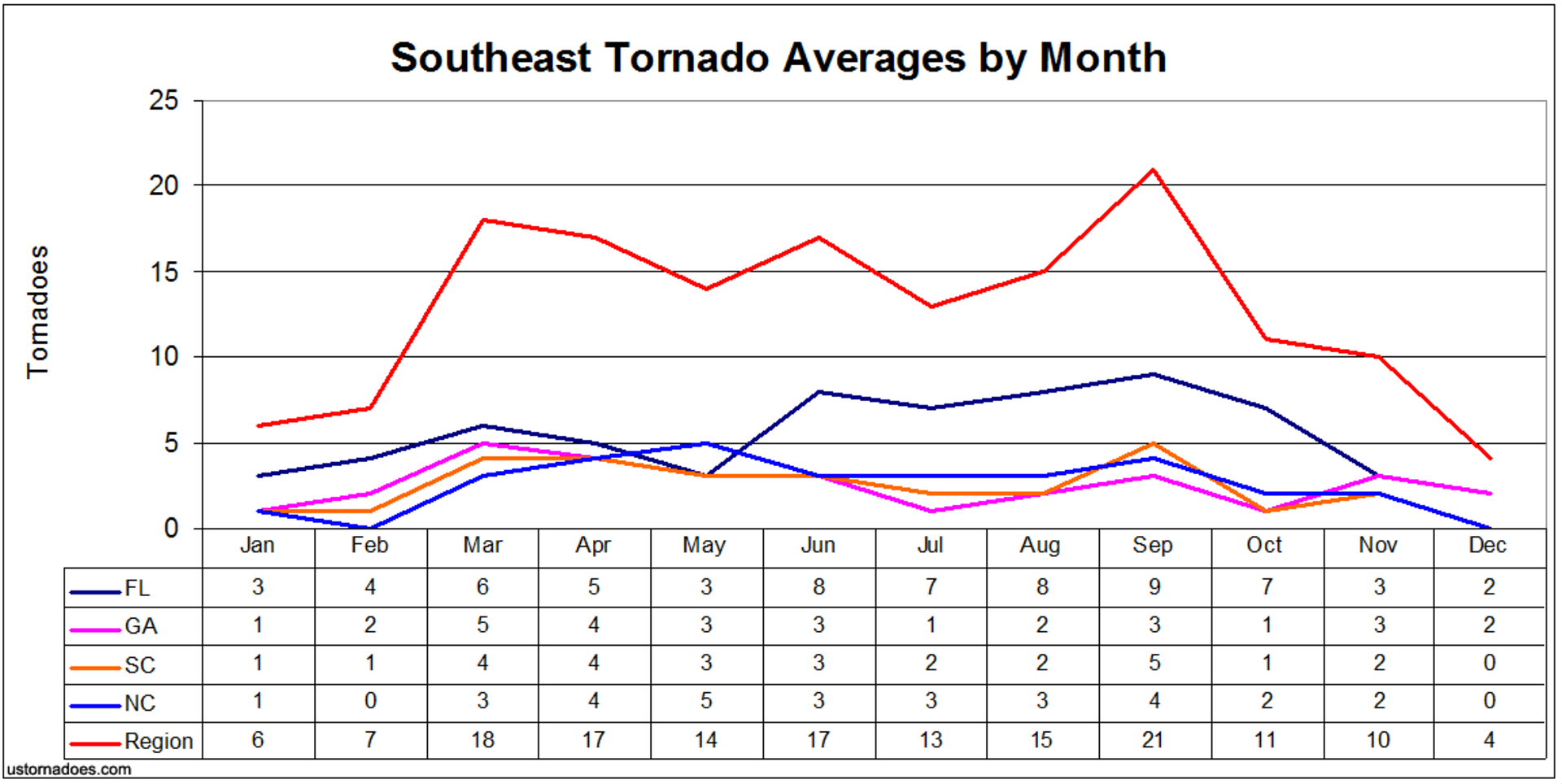
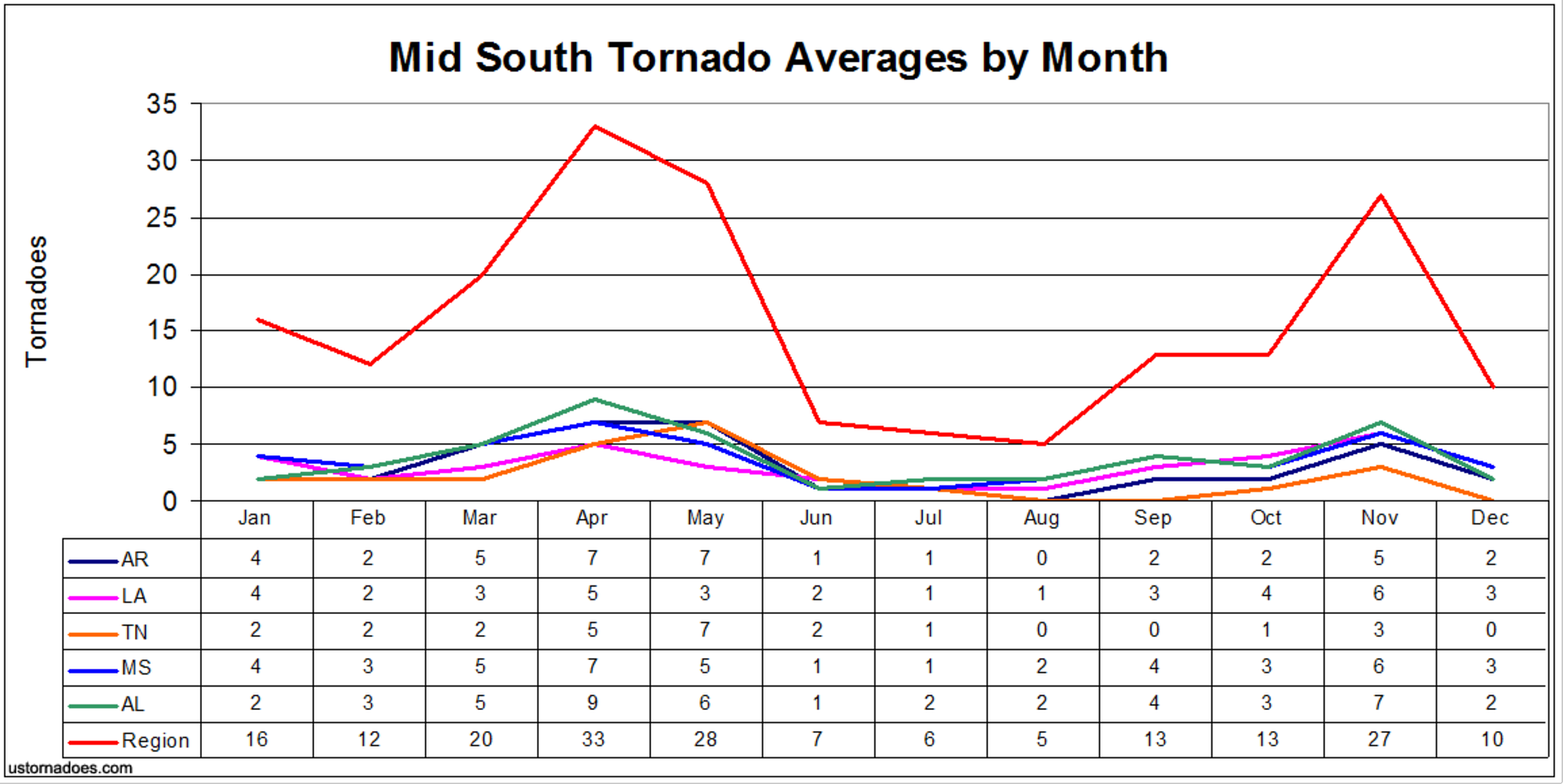
Much of Dixie Alley, which extends pretty much across the lower Mississippi Valley, experiences a fairly active tornado season during the fall months. From eastern Texas to the Carolinas and as far north as Missouri and Kentucky, tornadoes here can be more frequent than during some of the summer months. Not only that, data shows that they can be stronger than tornadoes in other areas even when formed in the Spring, and that they can be on the ground for much longer periods of time.
According to the Storm Prediction Center in Norman, Oklahoma, the reason tornadoes in the southeast U.S. are on the ground longer, is not geography related, but rather related to the time of the year when they occur.
In this corner of the country, they are more common in early spring or late fall when the atmosphere is more volatile, meaning that storms forming in such an environment can spawn longer-lasting and faster-moving tornadoes.
![]() Tornado 101: Everything you need to know about staying safe
Tornado 101: Everything you need to know about staying safe
Tornadoes by season (via: USTornadoes.com):
So how active will tornado season be this Fall 2016 in Dixie Alley? That certainly will depend on a number of factors, some of which have been outlined.
Sea Surface Temperatures in the Gulf of Mexico and off the southeast U.S. coast are well above normal, meaning the potential moisture for massive thunderstorms to form is there.
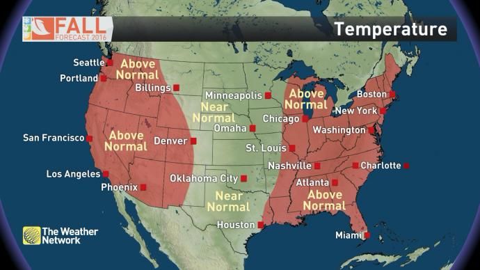
However, fall weather forecasts show below normal precipitation and above normal temperatures over a large portion of the region, and that could mean we could be facing a period of less active weather overall.
2016 Fall Temperature Forecast:
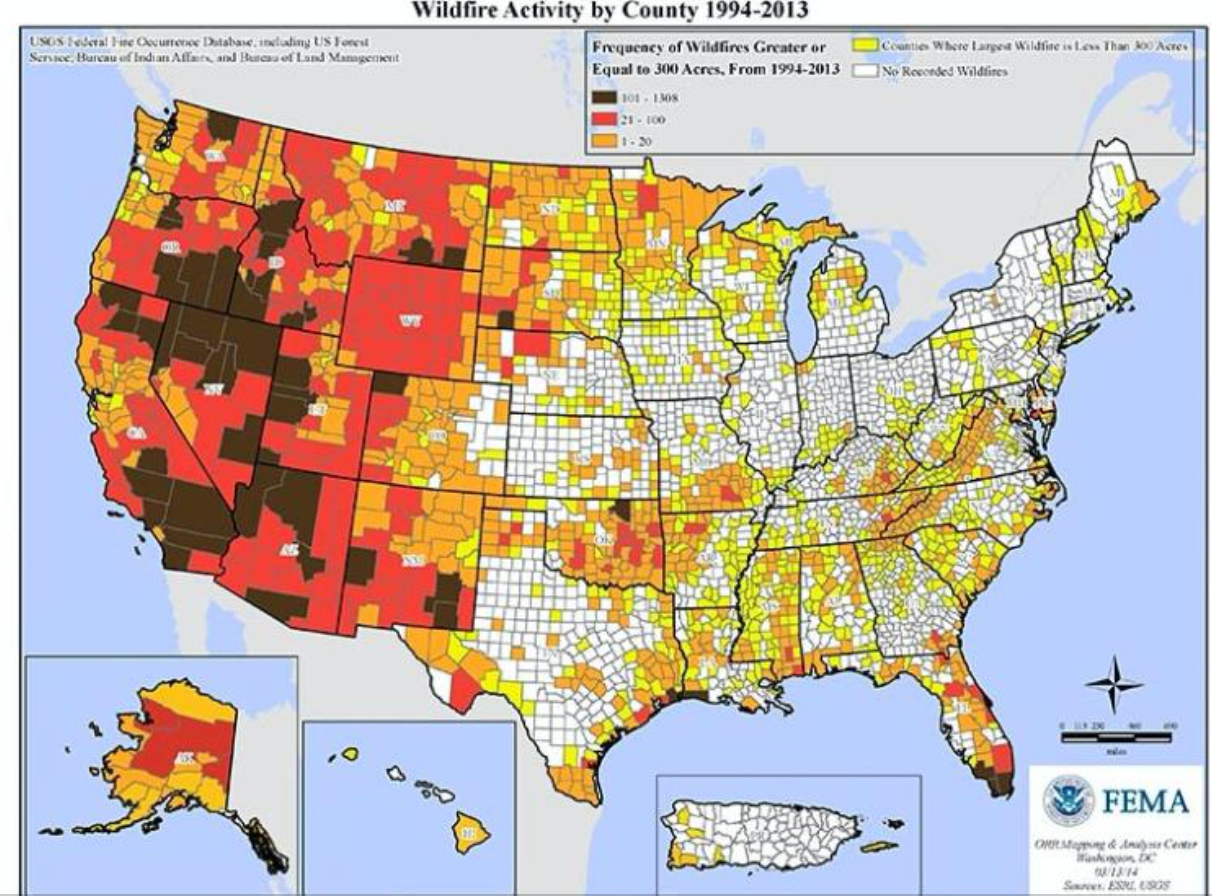
Fire danger on the rise over much of the west during the fall
Many forested areas of the western U.S. look at fall as the number one season for fire hazard. California is normally the most affected state, especially because the hot dry summers simmer much of the vegetation just before the fall, and then fall itself can also be warm and dry on occasions.
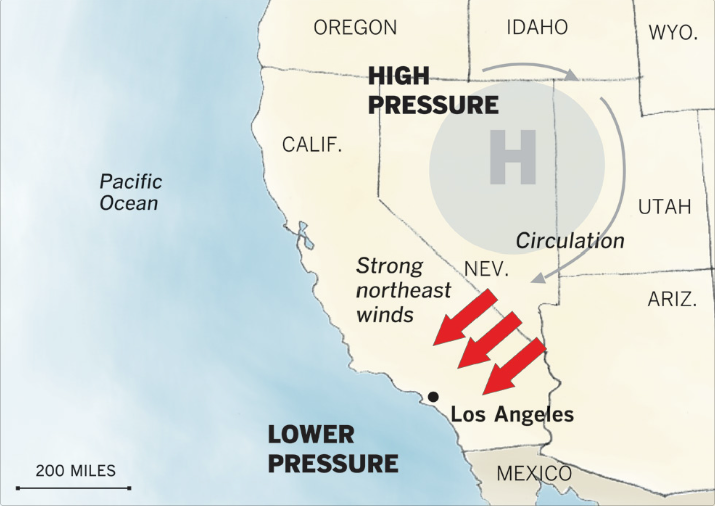
In California, the months of October and November display weather that is frequently affected by a local wind called Santa Ana.
These local hot winds blow when a high pressure centre forms over the Great Basin east of California, the air then flows from the high towards coastal areas of California making the air descend in elevation and become compressed. This compressional heating leads to soaring temperatures and very low relative humidity values along a large portion of the coast. Such a volatile situation can arrive in less than 24 hours, when the dominant cool, moist Pacific air flow is replaced in just a matter of hours by a dry scorching Santa Ana wind.
Santa Ana wind weather pattern:
In California summer fires tend to burn between June and September, while Santa Ana related fires are more common in Fall. Also important is that non-Santa Ana fires tend to burn more slowly, while Santa Ana fires burn fast and are much more dangerous, often doing half their total damage in the first 24 hours after they are sparked.
![]() STORM TOOL KIT: Be prepared for severe weather with The Weather Network's online essentials: ALERTS | LIVE RADAR | UPLOAD PHOTOS/VIDEOS | LATEST NEWS | FOLLOW ON TWITTER | HIGHWAY FORECAST | AIRPORT FORECAST
STORM TOOL KIT: Be prepared for severe weather with The Weather Network's online essentials: ALERTS | LIVE RADAR | UPLOAD PHOTOS/VIDEOS | LATEST NEWS | FOLLOW ON TWITTER | HIGHWAY FORECAST | AIRPORT FORECAST
Source: US Drought Monitor | NOAA | USTornadoes.com | FEMA | Tornado thumbnail image via Wikipedia Creative Commons file photo
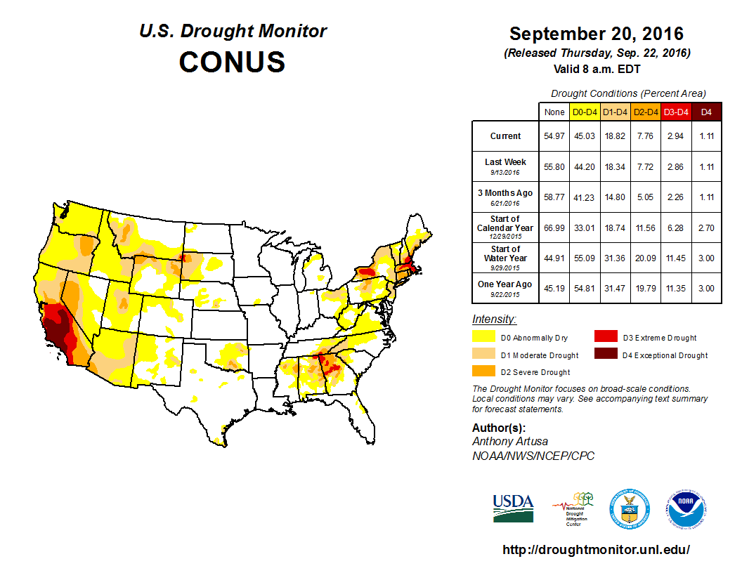
Unfortunately, regardless of how hot and dry this past summer was in many areas of the western U.S., the extreme and prolonged drought experienced over the past four years in the region makes this fall an extremely dangerous period, especially considering that the first Santa Ana wind episode is just around the corner.
WATCH BELOW: A look into Canada's winter 2016-2017

