How climate change has influenced 2020's Atlantic hurricane season

Climate scientists say that rapidly intensifying and stalling hurricanes are becoming more common due to human-released greenhouse gas emissions.
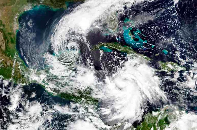
Scientists have confirmed the links between 2020’s record-breaking Atlantic hurricane season and the changing climate. Amid the COVID-19 pandemic, scorching heat waves in the Arctic and catastrophic wildfires in the Western U.S., eyes were drawn to the unusually hyperactive Atlantic basin, a trend that is expected to become increasingly common in the coming decades.
There were 30 named storms, which is the highest number on record and six major hurricanes, which is a tie for the second highest on record. Twelve named storms made landfall in the U.S., which exceeds the previous record of nine in 1916.
Forecasters began warning of an above-active hurricane season in the spring based on the absence of an El Niño and the potential for abnormally warm tropical Atlantic sea surface temperatures, which increases the threat for more storm development, as tropical cyclones are fueled by warm ocean waters.
Their early warnings came to fruition - September 10 marked the peak of hurricane season in the Atlantic and less than two weeks later forecasters ran out of traditional names for all the tropical cyclones and had to switch to the Greek alphabet. A La Niña Advisory was issued on the same day, which is related to weaker vertical wind shear, trade winds and less atmospheric stability, which all could support more hurricanes forming in the Atlantic basin.
In addition to the conditions that are optimal for hurricane formation, climate scientists say that 2020 is an example of how climate change is influencing the Atlantic hurricane season. Rapid intensification and stalling storms are two of the most prominent hurricane behaviours that are being highlighted. See below for an explanation of what the current research tells us about how hurricanes are being affected by climate change.
QUICKLY INTENSIFYING
Forecasters began using the Greek alphabet to name tropical storms after they ran out of traditional names mid-September. The only time this has happened was during 2005 when several record-breaking hurricanes made history, including Katrina, which claimed over 1,200 lives in the United States.
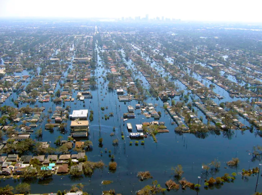
View of flooded New Orleans, Louisiana on September 11, 2005 in the aftermath of Hurricane Katrina. Credit: NOAA/ Wikimedia Commons
Several hurricanes in 2020 intensified at extremely rapid rates that shattered several records. Within a six-hour period on September 18, Tropical Storm Wilfred, Subtropical Storm Alpha, and Tropical Storm Beta were named by the National Hurricane Center (NHC). According to Phil Klotzbach, a meteorologist at Colorado State University, this was the first time since August 15, 1893 that three storms formed on the same calendar day.
Climate scientists confirm that the noticeable changes in the Atlantic hurricane season are not due to natural changes in the environment. A study published in Nature Communications in 2019 found that the “highly unusual” trend of Atlantic hurricanes rapidly intensifying from 1982-2009 could only be explained when human-caused climate change was analyzed as a contributing factor.
NOAA researchers say that high levels of greenhouse gases are reducing vertical wind shear along the U.S. East Coast, which is a foreboding projection for the region. NOAA explains that this shear acts like a “speed bump” to hurricanes that are approaching the coast, which prevents them from rapidly intensifying before making landfall. At least 75 per cent of NOAA’s climate projections indicate that vertical wind shear will decline during peak hurricane season by 2100, which will leave heavily populated coastlines vulnerable to storms that could rapidly intensify as they approach.
Hurricane Laura rapidly strengthened by 105 km/h in just 24 hours before it made landfall in Louisiana on August 27, 2020. As Laura approached the U.S. coastline, the NHC warned that “life-threatening storm surge” from this storm could be “unsurvivable.” Jeff Masters, a meteorologist who received his B.Sc., M.Sc., and Ph.D. degrees from the University of Michigan, notes that Laura’s rapid intensification was similar to Hurricane Michael (2018) and Hurricane Harvey (2017), which both strengthened between 60-70 km/h in a 24 hour period before making landfall in the U.S.
“Unfortunately, not only is human-caused climate change making the strongest hurricanes stronger, it is also making dangerous rapidly intensifying hurricanes like Laura and Michael and Harvey more common,” Masters says.
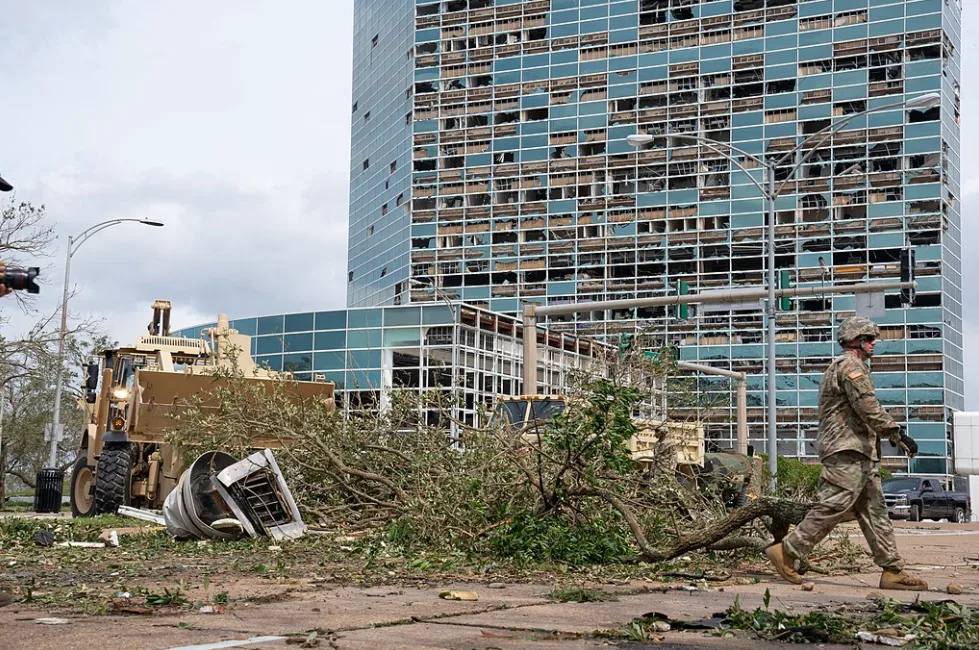
Soldiers from the Louisiana National Guard respond immediately after Hurricane Laura destroyed much of Lake Charles. Credit: Josiah Pugh/ Wikimedia Commons
Experts warn that rapidly intensifying hurricanes are especially dangerous for communities that are in the storm’s path because the lack of warning makes it difficult to properly prepare and evacuate soon enough. This type of hurricane behaviour is particularly challenging for forecasters as it complicates how they can communicate the storm’s risk well in advance of it making landfall.
A study published by the Bulletin of the American Meteorological Society (AMS) compared the intensification speeds of landfalling U.S. hurricanes from 1979-2005 to hurricane activity that is expected by 2100. The conditions for the future projects assumed that greenhouse gas emissions will continue at their present-day rate, and the models showed that rapidly intensifying hurricanes will become much more common.
The AMS’s study found that the odds of a hurricane intensifying by 111 km/h or more in the 24 hours just before landfall were about once every 100 years in the climate from 1979-2005, but increased to once every 5 to 10 years by 2100. Nearly all of the rapidly intensifying hurricanes occurred along the coast of the Gulf of Mexico, and the major areas facing the highest risk include Houston, New Orleans, Tampa/ St. Petersburg, and Miami.
Other findings from the AMS’s study include a 118 per cent increase in the frequency of tropical cyclones and a 10 per cent increase in their lifetime maximum wind speed.
SLOWING DOWN AND STALLING
Researchers from Environment Canada and Climate Change found that extreme precipitation events are becoming more intense and are becoming more likely to occur as the climate warms. Since the atmosphere holds more water vapour when it is warmer, roughly 7 per cent more per 1°C, hurricanes can produce greater amounts of precipitation. Warmer sea surface temperatures also help fuel wind speeds, which allows them to rapidly strengthen.
The warmer atmosphere allows hurricanes to unleash more rain, but the sluggish pace of certain hurricanes have been an especially apparent impact of the changing climate.
Hurricane Sally made landfall on September 16 near Gulf Shores, Alabama after unexpectedly re-intensifying from Category 1 to Category 2 status. Sally began churning extremely slowly when it approached Mississippi’s coastline at just 4 km/h, which allowed for a prolonged period of significant rainfall. Several coastal areas were warned by the NHC that over 600 mm of rain could fall and the potential of “life-threatening storm surge.”
Sally is the most recent example of a hurricane stalling over a populated area and causing devastating damage. In 2019, Hurricane Dorian became one of the most powerful Atlantic hurricanes on record and stalled over part of the Bahamas for roughly 36 hours. The Category 5 storm brought over 900 mm of rain to some of the islands and left 70,000 people homeless with an official death toll of 74.

A U.S. Coast Guard Response Team rescued nine people and one dog Sept. 16, 2020 near Navarre Beach, Florida after Hurricane Sally made landfall. Credit: United States Coast Guard/ Wikimedia Commons
Sea surface temperatures are also rising as greenhouse gas emissions climb and scientists say that this is affecting how tropical cyclones travel over land. A study published in Nature analyzed the intensity data from storms that made landfall in North America between 1967-2018 and found that tropical storms are decaying much more slowly 24 hours after landfall. The researchers say that the slower decay is largely connected to warming sea surface temperatures in the Gulf of Mexico and the western Caribbean because it fuels the amount of moisture in a hurricane and allows it to maintain its strength for longer.
In 2017, Hurricane Harvey made landfall as a Category 4 hurricane and stalled over parts of southern Texas for several days and unleashed 1,300 mm of rainfall in Cedar Bayou, which set a new North American record.
These storms are just a few of the hurricanes that have stalled and caused extensive damage. Scientists have noted that the translation speeds of hurricanes and tropical storms, which is how quickly the storms move over an area, decreased by about 10 percent from 1949 to 2016.
James Kossin, a climate scientist in NOAA's Center for Weather and Climate, warns hurricanes could be stalling due to human-released greenhouse gases causing tropical circulation changes and more water vapour in the atmosphere. Kossin says hurricanes are continuously bringing unprecedented rainfall totals and cites Hurricane Harvey as a “notable example of the relationship between regional rainfall amounts and tropical-cyclone translation speed.”
“As the atmosphere warms, the general circulation of our atmosphere changes. These new circulation patterns naturally vary by region and time of year, but there is evidence that anthropogenic warming causes a general weakening of the summertime tropical circulation. Since winds that carry these tropical cyclones during the summer months are weaker, this in part explains why the translation speed of tropical cyclones has also slowed down with the warming,” says Dr. Mario Picazo, meteorologist and professor at the University of California, Los Angeles (UCLA).
Picazo explains beyond circulation changes, human-caused climate change is behind the increase in precipitation rates associated with tropical cyclones. A warmer environment causes the atmosphere to hold more water vapour, which will increase the amount of rainfall released from tropical cyclones in the coming years.
Thumbnail credit: NASA
This article was originally published on September 24, 2020 and updated on December 13, 2020.