Don Valley Parkway flooding. Here's why it happens so often
Visit the Summer Forecast Guide to the Season for the 2017 Summer Forecast, Fall Weather Preview and much more.
Meteorologist/Science Writer
Thursday, May 25, 2017, 3:18 PM - The situation is so "classic" that it was instantly recognizable. Staring up at ominous dark-grey, rain-laden clouds sweeping across the entire Greater Toronto Area, one thought crossed the mind: It wouldn't be too long before social media would be lighting up with reports that the south-end of Toronto's Don Valley Parkway was, once again, flooded.
Current Conditions
On May 25, 2017, the Toronto and Region Conservation Authority had issued a Flood Watch for waterways throughout the GTA, due to the passing weather system, but then downgraded the alert to a Watershed Conditions Statement: Water Safety after the rains had diminished.
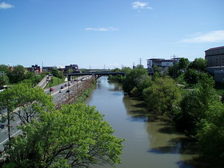
With the Don River at Dundas peaking above the High Alarm mark as of Thursday afternoon, however, at only around 10 cm below the level of the DVP, the TRCA had the river on alert status.
Now that the river has subsided to well below the High Alarm mark, the alert has been called off.
![]() RELATED: More soaking rains raise risk of flooding along Lake Ontario
RELATED: More soaking rains raise risk of flooding along Lake Ontario
So why does the Don Valley flood so often?
How many times has it happened before? A particularly strong rain storm washes over the GTA, or a concentrated heavy downpour drenches the east end of Toronto, and suddenly commuting along the Don Valley Parkway goes from simply slow to downright hazardous as the Don River crests its banks and envelopes the traffic artery's south end.
The answer to the above question? Too often.
In fact, it's been happening ever since people settled in this region, and even going back much further than that - all the way to the last time the glaciers retreated from southern Ontario, roughly 12,000 years ago.
|
|
The Don River, which is about 15 metres wide these days, managed to carve out the entire 400-metre-wide Don Valley since the last glacial period, as it meandered back and forth, cutting down through the layers of Earth. Even in the times when the first people settled here, up through the establishment of a colony and the city of Toronto building up around it, the meanders in the river made it prone to overland flooding whenever heavy rains fell across the area.
The Don Improvement Plan, in 1886, dug out a long trench that cut through several of the meanders at the south end of the river, and then filled in all the twists and turns, effectively deepening and straightening that section of it. This did help with the immediate issue of overland flooding, but with the city growing up and around the valley since, and with developments spreading down into it as well, any benefits from the plan didn't last long.
It was Hurricane Hazel, which blasted across Toronto in 1954, that served as an effective wake-up call for the disaster potential that still existed in the valley. River flows during the storm have been estimated at around 1,700 cubic metres per second, which is over 400 times greater than the normal average flow the river experiences. There hasn't been anything quite that bad since, but the government did ban development in the valley (as well as other flood plains) as a result of that disaster.
Still, less than four years later, in 1958, construction crews broke ground on the newly approved Don Valley Parkway, which was going to wind its way right through the middle of the Don River's flood plain, and the city continued to grow around it, laying down even more concrete and asphalt up and down the lands that border both sides of the river valley.
![]() RELATED: Downpours in Ontario: Are you prepared for possible floods?
RELATED: Downpours in Ontario: Are you prepared for possible floods?
This is what it really comes down to for flooding along the Don River and the Don Valley Parkway today - urban development.
If rainfall rates are high enough, overland flooding is a foregone conclusion, regardless of where you live or what waterway you're dealing with. This is simply a combination of hydrology and geology.
The ground, depending on what it's made of, can only absorb so much water so quickly. The more sandy the top soil, the more water it can absorb, and the faster it can absorb it, since the individual soil particles are larger and have more space in between them. If there's more clay in the soil, less water can be absorbed and it's absorbed slower, since the grains are finer, with less space between them. No matter what the soil type, though, it allows at least some water absorption and movement, thus provided a natural buffer to slow the transfer of rain water from where it falls to where it enters the flow of any rivers and streams in the area.
On the other hand, artificial surfaces - concrete and asphalt - are specifically designed to prevent water from penetrating them, or at least to keep water intrusion to a minimum, to improve their durability and strength. Water falling on these surfaces just quickly flows along the top of the surface, pooling in any low areas where flow stagnates, until it reaches ground that will absorb it or it flows into a drain. Drains, for their part, are effective at moving that water along, but since they lead to concrete storm sewers, they just continue the problem, quickly and efficiently moving that rainwater along towards waterways. That removes the water from being an immediate problem, however the local natural waterways that water is funneled towards formed under conditions where the natural buffer of the soil was in place. Consequently, they can't handle so much water being added to their flow so quickly, and they swell, cresting their banks and causing localized flooding.
This is exactly what happened as the east end of Toronto became more urbanized. Paving over the surfaces there gradually replaced the local geological buffer for rainwater with a series of artificial channels (both on the surface and underground) that quickly funneled rain water directly into the flow of the Don River. The result: all that flow converges on the Lower Don, "piling up" and turning the Parkway into an extension of the river.
Is this going to get any better?
Unfortunately, in all likelihood, this is not going to get better anytime soon, or at least not quickly.
Conservation Authority staff work very hard on flood management, of course. However, there's only so much that you can do with a river that's been flooding since before the city was even here.
Recently, a fairly aggressive flood management plan was put into place for the south end of the Don Valley, sparking off major excavation and construction to try to deal with the problem. However, even as of April 2014, both the Lower Don and Brickworks regions of the Don River - both of which border the last stretch of the Parkway before it merges with the Gardner Expressway - were still identified as 'flood vulnerable areas' on Toronto and Region Conversation Authority maps.
There are a few ways that we can help, though.
One way is a process called daylighting. As the city has grown, many of the streams and creeks that run through the area have been preserved, but now run through artificial environments - metal pipes and concrete sewers that keep the water from being absorbed by natural soils. Daylighting returns these streams and rivers to a more natural state, allowing more water to soak into the ground, thus restoring part of that natural buffer for the river.
Also, technology can help as well as hinder, like the development of a new product called Topmix Permeable, by British company Tarmac, which has been nickname "Thirsty Concrete."
Simply by replacing the fine grain materials of the concrete mix with coarse grains of crushed granite, Tarmac has produced a porous version that emulates how sandy soils respond to rainfall. According to the company, this concrete can deal with a flow rate of up to 36,000 millimetres per hour. That's over 700 times better than what sand can handle, and somewhere around 2,000 times better than the permeability of your average soil. For comparison, on July 8, 2013, when 126 mm of rainfall caused extensive flooding throughout the GTA, it fell mostly over a two-hour period, although it doesn't even come close to what this new concrete could handle.
Perhaps, as the city continually repaves Toronto's roadways, a slow replacement of fine-grain impermeable concretes with coarse-grain permeable ones, along with preservation of green-space and an expansion of the daylighting process, could help enough to eventually bring this problem under control.
One factor working against these preparations and techniques is climate change. It's a simple fact that when you raise the temperature of the air, that air is capable of holding more water vapour, and more water vapour in the air means more potential rain to fall. So, as Earth's temperature continues to tick upwards due to increased greenhouse gas emissions, there's a greater risk for storms and weather systems to produce extreme rainfall amounts, and thus for the Don Valley Parkway to see more flooding events.
EDITOR'S NOTE: This article originally ran on June 26, 2014. It has been updated and expanded to reflect current developments.
Sources: City of Toronto | TRCA | TRCA Flood Management | Vanishing Point | Tarmac


