Upside? Tuesday's storm will be over quick for Ontario
Meteorologist
Monday, March 2, 2015, 8:41 PM - After a bitterly cold February we will finally get some relief from the cold, although it comes at a price -- the next low pressure system to hit the province Tuesday. Come Tuesday, highs near the freezing mark are expected for south central Ontario and around the Greater Toronto Area with southwestern Ontario expected to reach the above freezing mark late in the day through the evening. Eastern Ontario will still sit at or slightly below the freezing mark and north central Ontario, will still be in the cold, but only into the mid-to-high minus single digits.
The milder air surging north is what is making for a challenging forecast when it comes to precipitation types associated with this system. With these types of systems, milder air pushes in aloft (higher in the atmosphere) faster than at the surface. This results in a layer of the atmosphere above the surface to be above freezing while a shallow layer at the surface remain at or just below freezing. Below, the top image shows temperatures at 850 millibars (mb) which is about 1km in altitude. The bottom image, below, shows the surface temperatures. The thick white lines indicate where the 0C line is. Notice how on the 850mb chart the 0C line is ahead of the surface freezing line. Depending on the depth of the below freezing layer we will get either freezing rain or ice pellets with this area between the two 0C lines.
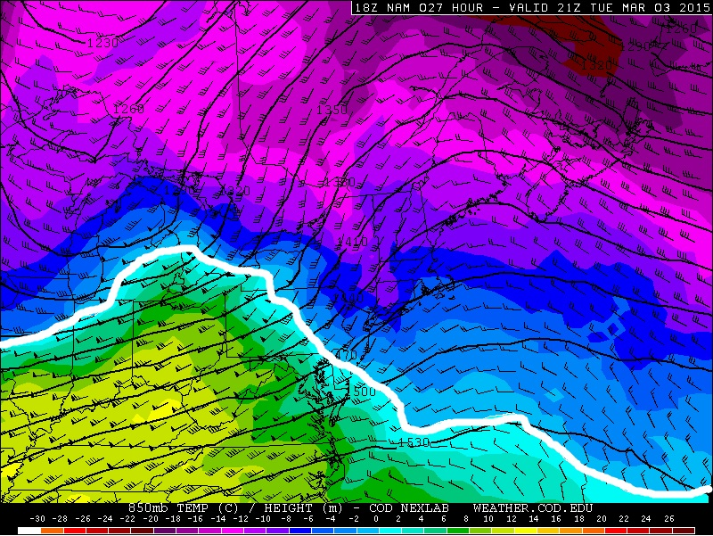
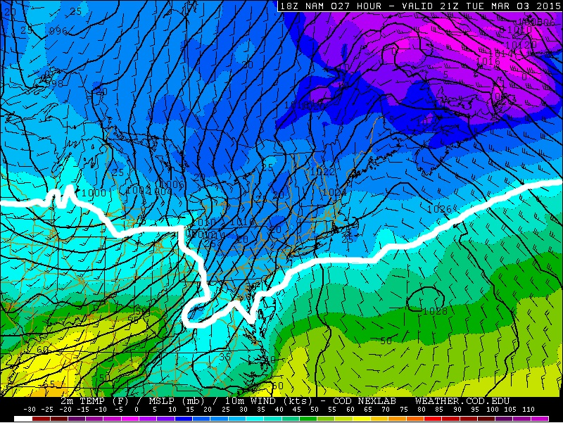
Figure 1. Top shows 850 mb winds and temperatures. Bottom shows surface temperatures, winds, and pressure. The thick white line indicates the 0oC line.
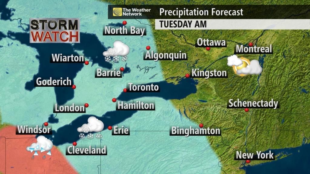
Any slight shift in the low’s track, north or south, will have the freezing rain/ice pellet line meander around some. As it stands our current forecast shows that we expect the precipitation to start as snow early Tuesday morning, before sunrise, which will spread into south central Ontario and the GTA through the mid-to-late morning hours. At this point it does appear the GTA will avoid the snow for much of the morning commute, unless you are coming in from areas like Kitchener and Hamilton where the snow is expected to start to fall during the commute.
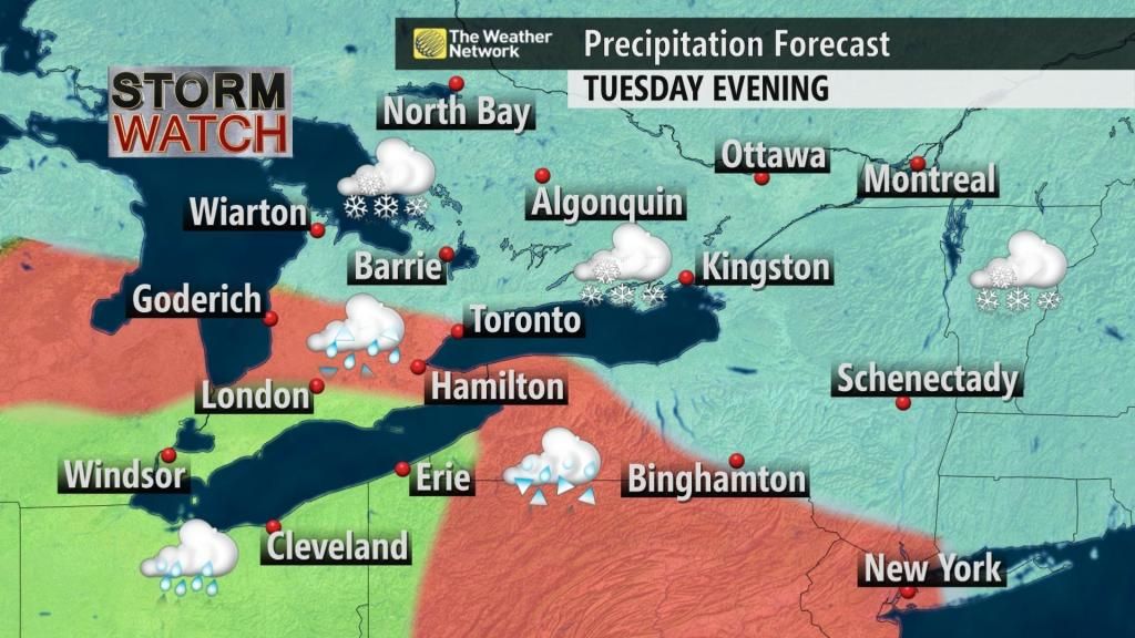
The comparison of surface temperatures and temperatures aloft is for Tuesday afternoon. It’s during this time frame where we expect to see a transition over to ice pellets and freezing rain through southern Ontario. The precipitation forecast below indicates where we think the best chance of freezing rain ice pellets are through the afternoon hours Tuesday.
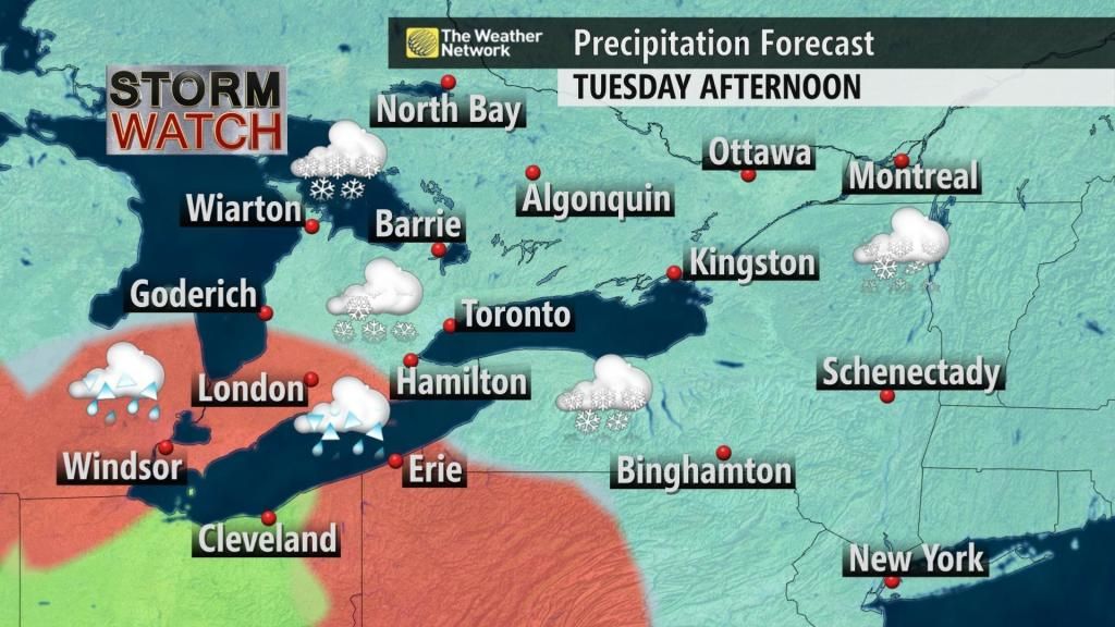
Through Tuesday evening is where some uncertainty still lies. Forecast models are showing some disagreement with how far north the milder air will push and thus how far north the ice pellet/freezing line will get as well. Some try to push it into and well north of the GTA while some keep it just south. At this point our thinking is the mixing line will sit through to just south of the GTA Tuesday evening leading to a mix of snow and ice pellets. The more substantial freezing rain risk will likely be from Niagara, through Hamilton, over to the Grand Bend area. Through the overnight it is likely that Hamilton Niagara, and southwestern Ontario transition over to straight rain as temperatures climb to above freezing mark.
What are we looking at in terms of accumulations then? Well, we have one thing acting in our favour and that is a very fast jet stream. The figure below shows the 250mb jet stream forecast for Tuesday afternoon and evening which is indicating wind speeds near 135 knots to 160 knots. That is about 250 km/h to 296 kilometres per hour. This will lead to a very fast moving system and will keep accumulations relatively low compared to what they could potentially be given the good amounts of moisture surging north with the low.
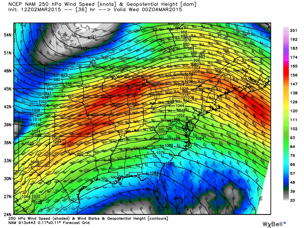
Figure 2. 12Z (7am) March 3, 2015 NAM forecast model 250mb jet stream forecast valid 7pm Tuesday March 3, 2015.
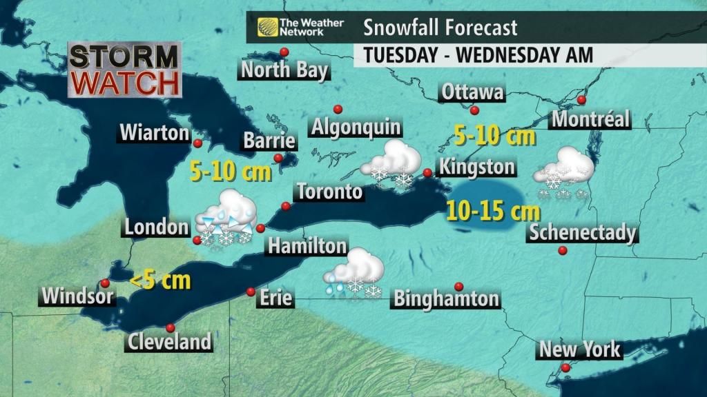
Our latest forecast currently shows generally 5-10 cm are likely across much of the province. With the transitioning through Niagara, Hamilton, and southwestern Ontario, accumulations here are expected to be limited to near 5 cm or less. In terms of ice accretion, not very much is likely again thanks to the highs speeds of this system. Mainly trace amounts to possibly 2 mm of ice accretion is possible, but with temperatures to climb above 0C for the higher risk areas Tuesday evening and overnight, the ice should not stick around very long although it is important to note that sub-freezing air will push back in for Wednesday morning; this will make any untreated roads slick for the morning commute and potential for black ice.
Will the milder air stay? Well, not exactly -- but it’s not entirely bad news either.
Behind this system another shot of Arctic air will be surging into the province. Figure 3 below shows the Canadian model 850 mb temperature anomaly forecast for Thursday morning. We can see another shot of well below normal temperatures (areas with the deep purple colours) will be surging in that will bring temperatures near 5C to 10C below seasonal for Thursday and Friday. Below seasonal temperature will continue to be in place through the weekend but likely not to be as dramatic. It’s not until early to mid next week when we will finally have temperatures back up to even slightly above seasonal. For most of southern Ontario normal temperatures for this time of year are highs near 2C and lows near -6 degrees Celsius.
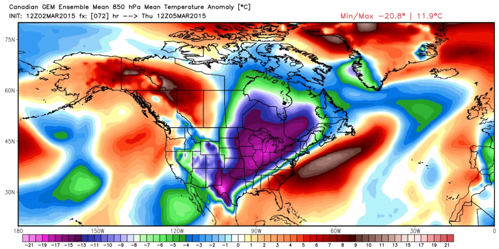
Figure 3. Canadian GLB ensemble mean temperature anomaly forecast for 850mb valid Thursday morning.


