Unusual Rex Block brings unseasonable cold to eastern Canada
Meteorologist/Science Writer
Monday, May 8, 2017, 1:23 PM - Canada is split nearly down the middle this week, with chills in the east and heat in the west, thanks to an unusual weather feature known as a Rex Block. So, what is a Rex Block and what makes this one so unusual?
Experiencing some cool temperatures in mid-spring isn't all that unusual in Canada, but something strange is going on this week, with unseasonably cool temperatures locked in across the eastern half of Canada, coupled with some unseasonably warm weather across the west.
The weather pattern responsible for this goes by a special name - as many of these do. It's known as a 'Rex Block'.
What is a Rex Block?
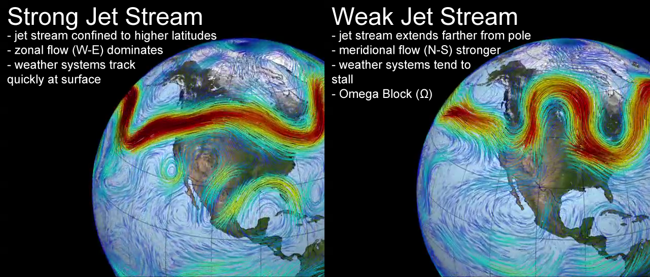
We've all heard of the jet stream. This ribbon of fast-moving air, which flows along at around 10 kilometres above the ground, makes an appearance on nearly every weather map we see on television, due to its ability to strongly influence our day-to-day weather.
Not only does the jet stream affect the kind of weather we see - cloudy and unsettled versus clear and calm - but it can also determine how long we are locked in under those conditions, based on how strongly the winds inside the stream are blowing. A strong jet stream may have a few small bends and wiggles in the flow, but in general, it allows weather systems at the surface to track along fairly quickly. A weaker jet stream, though, allows bigger bends and wiggles, which turn into deep troughs and strong ridges, which slow down the west-to-east movement of surface weather systems.
Credit: NASA Goddard Scientific Visualization Studio/Scott Sutherland
A fairly well-known blocking weather pattern, shown to the right, above, is the 'Omega Block' - so-named because the jet stream takes on a flow pattern that looks like the Greek letter omega, Ω, with a strong ridge of high pressure flanked by two low pressure troughs. Since the ridge in the middle has higher pressure and thus higher air density than the low pressure troughs, this whole pattern can easily become stuck in place, because the low pressure troughs just don't have what it takes to push the high pressure ridges along. Under these conditions, surface weather patterns can get stuck in place for days at a time.
The 'Rex Block' looks quite different on a weather map, but it can cause the same kind of situation.
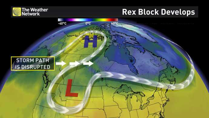
A classic west coast 'Rex Block' - named after Daniel F. Rex, the scientist who first described the pattern in 1950.
In this case, a high pressure ridge forms to the north of a low pressure trough, with the jet stream forming a backwards 'S' between them. Here, warm weather can be carried far to the north under the ridge, and cold weather can be drawn down far to the south, into the trough.
This combines two inherently slow-moving weather features - a high pressure ridge and a cut-off low - into a pattern with almost all of the air movement being North-South, and very little pushing it in a West-East direction. Thus, the pattern gets stuck in place, and until it finally breaks down, if it moves at all, it will only track very slowly across the continent.
While the Rex Block is in place, any weather systems that happen to form to the east of the Block will be able to proceed fairly quickly, but anything approaching from the west will be forced to go around, slowing its progress or possibly halting it altogether.
What's unusual about the Rex Block we're seeing this week is its location. The most common places to see a Rex Block are over the west coast of Canada and the United States, and over western Europe.
This one, however, is over the east, with the high pressure ridge over Newfoundland and Labrador, as well as northern Quebec, and the low pressure across Ontario, Quebec and southern Atlantic provinces, plus much of the northeastern United States.

As the weather forecast shows, the jet stream may change and shift over the next few days, but the basic pattern - high pressure north of low pressure - remains relatively constant.

The result of all of this? Some fairly unseasonably cool conditions in the eastern half of the country, and some slightly unseasonably warm weather in the west, with this pattern likely lasting until the weekend.


