NASA spies enormous new crack forming in Greenland glacier
Meteorologist/Science Writer
Monday, April 17, 2017, 8:51 PM - An immense new crack has formed in Greenland's Petermann glacier, and NASA scientists have now returned the first close-up images of the fissure, which may herald the birth of yet another massive iceberg from the glacier.
Petermann Glacier, located along the northern coast of Greenland, is one of the largest of the island nation's glaciers that connects the Greenland ice sheet directly to the ocean. The leading end of the glacier, which floats atop water as an immense ice shelf, has already lost enough ice since 2010 to cover the island of Manhattan six times over. Up until 2010, this tongue of ice stretched over 70 kilometres from the ice shelf's grounding line (the point where the ice is in direct contact with the island's bedrock) to the leading edge.
On August 5, 2010, a 250 square kilometre ice island broke off from the end of the shelf, then floated out of the glacier's fjord and into the waters of the Nares Strait, between Greenland and Canada's Ellesmere Island. It's area was roughly 4 times larger than the island of Manhattan, and it was considered the largest single chunk of ice lost from the Arctic since 1962. This shortened the ice shelf to just around 55 kilometres long.
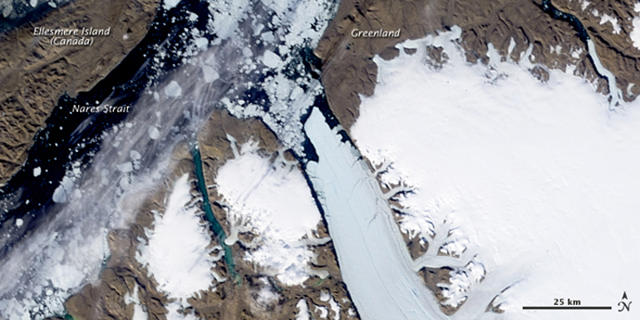
Petermann Glacier ice shelf, July 28, 2010. Credit: NASA Earth Observatory
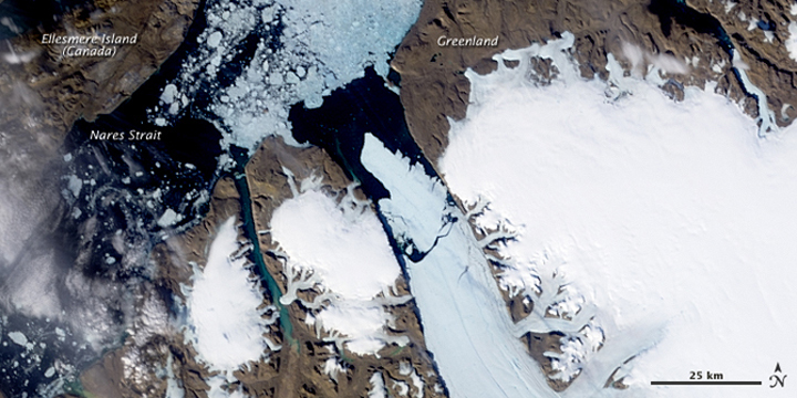
Petermann Glacier ice shelf, August 5, 2010. Credit: NASA Earth Observatory
Nearly two years later, on July 16, 2012, another ice island broke away, from a fissure in the ice that had been identified by satellite images back in 2001, and grew worse during the 2010 calving event. This iceberg was roughly 120 sq km in size, which is around twice as large as Manhattan, and it left the ice shelf at between 45 and 50 kilometres long.
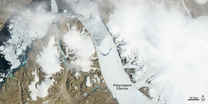
Petermann Glacier ice shelf, July 16, 2012. Credit: NASA Earth Observatory
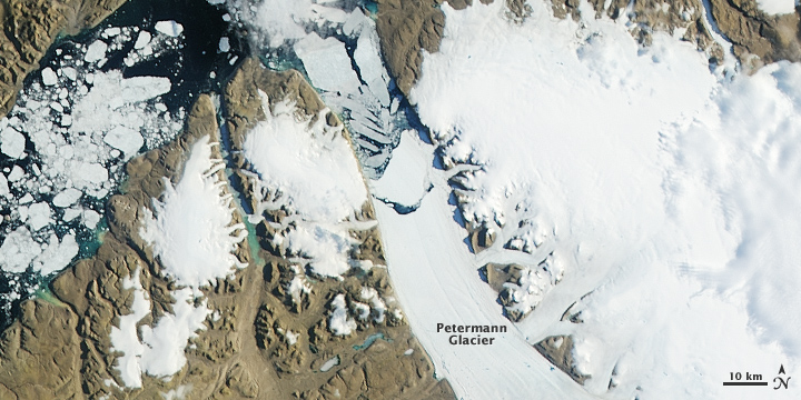
Petermann Glacier ice shelf, July 17, 2012. Credit: NASA Earth Observatory
Since then, the advancing motion of the glacier has pushed the leading edge out a few kilometres, and several cracks have shown up along the sides of the ice shelf, although none so far have presented the possibility of causing another calving event.
This latest crack was first spotted by Stef Lhermitte, a remote sensing scientist and assistant professor of Geoscience and Remote Sensing at the Delft University of Technology, in the Netherlands, via images taken by the ESA's Sentinel 2 satellite. What set it apart from the others is that it did not originate from the edge of the ice shelf, but from its centre.
Is this recent internal crack in #Petermann glacier the prelude of a new @Petermann_ice island? 1/5 pic.twitter.com/V8qKF1MwmC
— Stef Lhermitte (@StefLhermitte) April 12, 2017
Just after the crack was identified by Lhermitte, scientists from NASA's Operation Icebridge mission flew over Petermann Glacier, snapping photographs of the new rift.
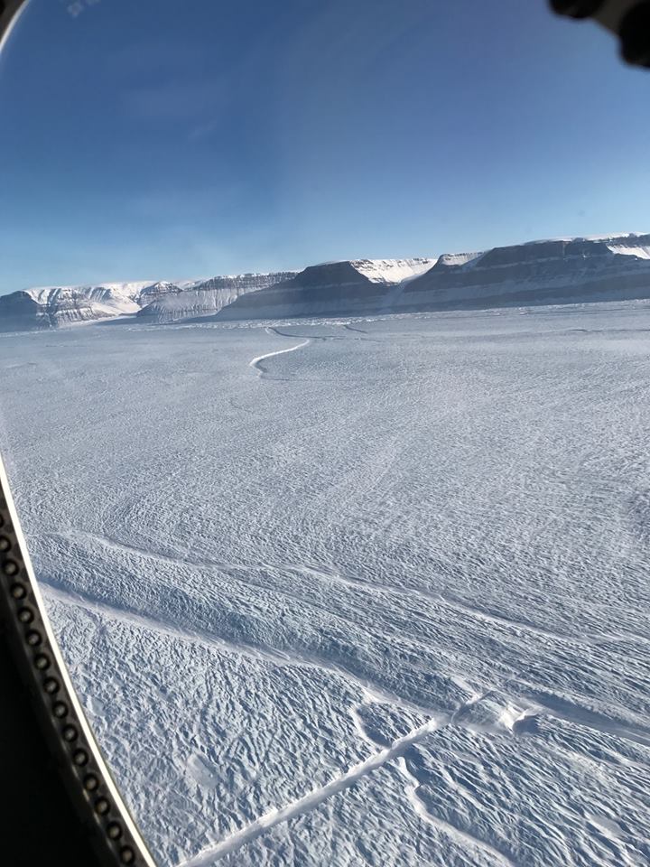
Credit: Kelly Brunt/NASA
A larger, older rift, which has been growing for at least the past two years, is visible in the distance. The new crack is near the bottom centre of the image, running from lower left towards middle-right.
According to an Operation Icebridge post on Facebook: "The shaded feature near bottom center is a medial flowline, whose presence may exert a stagnating effect on the propagation of the new rift toward the older one." This "medial flowline" is the larger feature that runs roughly perpendicular to the new crack.
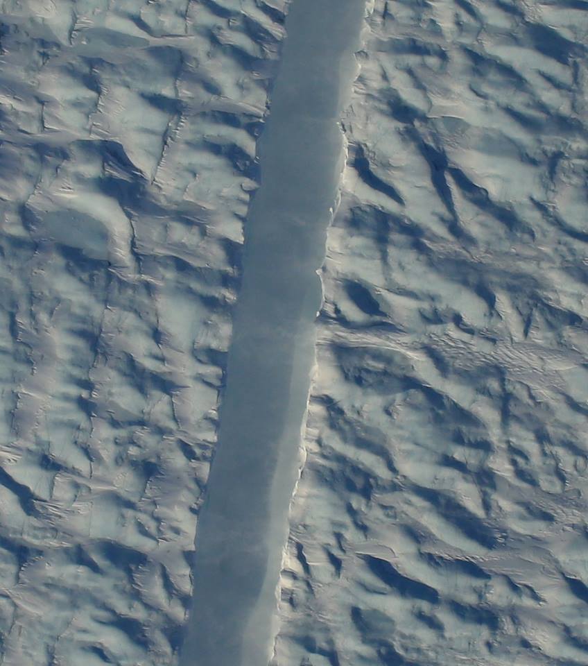
An overhead view of the crack. Credit: Gary Hoffmann/NASA
The location of this new crack is raising some questions, because these kinds of fissures don't usually form around the middle of the ice shelf. According to what Lhermitte posted on social media, it may have formed due to what's known as ocean forcing - when the ice shelf is weakened by warm ocean water underneath it.
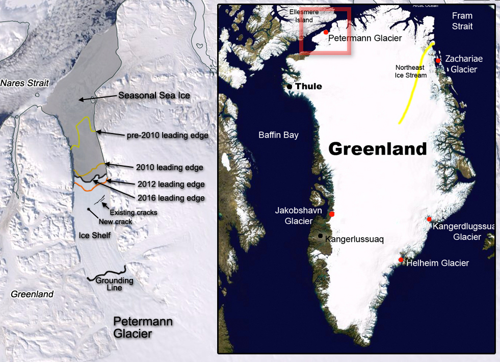
Petermann Glacier ice shelf, April 17, 2017. The leading edges of the ice shelf pre-2010, 2010, 2012 and 2016 are indicated, as well as the location of cracks in the ice shelf that have formed in recent years, the location of the most recent crack, and the location of the glacier's grounding line (where the ice rests on bedrock). Seasonal sea ice (shaded in grey) chokes the mouth of the fjord at this time of year. Inset image shows the location of the glacier. Credit: NASA Earth Observatory/NASA/S. Sutherland
Simply by comparing the various leading edges, it's clear that if this new crack is the start of a new calving event, the resulting ice island will be larger than the one that broke away in 2012, perhaps between 130 and 180 square kilometres.
Sources: NASA Operation Icebridge | Washington Post | NASA Earth Observatory (2010) | NASA Earth Observatory (2012)


