After mild weather, a pattern change drives temps down
Meteorologist
Sunday, March 27, 2016, 12:30 PM - The month of March has brought an extended period of mild, spring-like weather for the majority of Canadians, including the early appearance of temperatures greater than 20°C in southern Ontario.
![]() SPRING IS HERE: How will El Niño affect your spring? Find out with the The Weather Network’s Spring Forecast. #SpringForecast
SPRING IS HERE: How will El Niño affect your spring? Find out with the The Weather Network’s Spring Forecast. #SpringForecast
But don’t put away those winter jackets just yet, because after a stormy period at the end of the month, cold temperatures will rally for one last parting shot in early April, setting up a period of below seasonal temperatures for everyone east of the Rockies.
The final week of March will be punctuated by an ongoing series of storm systems tracking out of the American Great Plains, up through the Great Lakes, the St. Lawrence Valley, and across Atlantic Canada. This will bring several rounds of messy precipitation to the eastern half of the country.
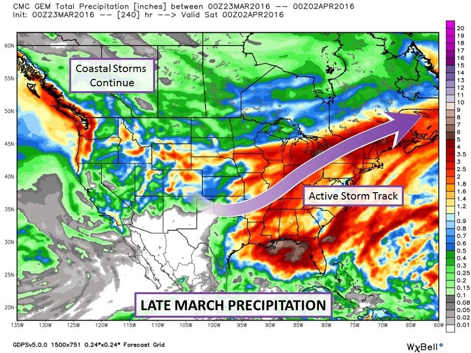
This image shows total model forecast precipitation between March 23 and April 1. The impacts of the active storm track are evident, with areas in red and orange racking up over 50 mm during the period. Across the northern flank of the storm track, much of this precipitation is likely to fall as snow, leading to significant accumulations.
In the west, the Prairies remain relatively dry for the next ten days, but the parade of Pacific storms will continue for the B.C. coast. March has seen a continuation of soggy conditions, with over 130 mm of rain recorded in Vancouver so far this month. But as we move into the final days of March and early April, relief is on the way in the form of a looming pattern change.
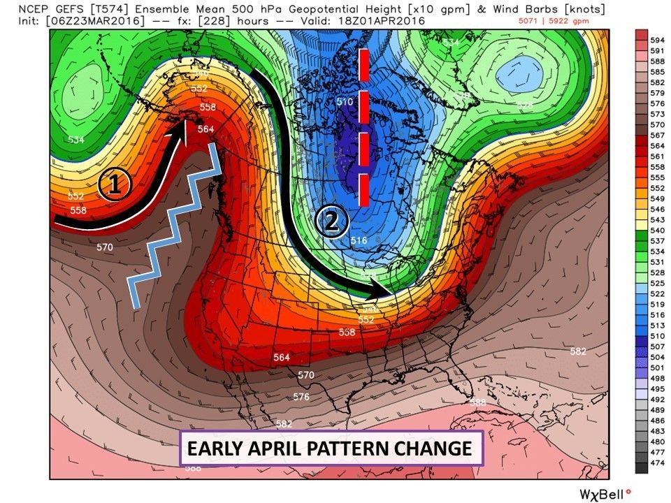
As we round the corner into April, here’s what we expect the pattern to look like. A strong ridge builds in across the west coast, shown here as a blue zig-zag line. The atmospheric flow can’t cut through the ridge, so instead it deflects north, taking the storm track up into the Gulf of Alaska (1). This will allow dry and mild conditions to take hold over British Columbia in the last few days of March, and continue into April.
As the ridge builds in however, it sets the stage for a deep, winter-like trough to set up over Hudson Bay, shown as a red dashed line. This will open the door for an outbreak of Arctic air, as flow sets up from over the pole down across the Prairies and into the Great Lakes (2).
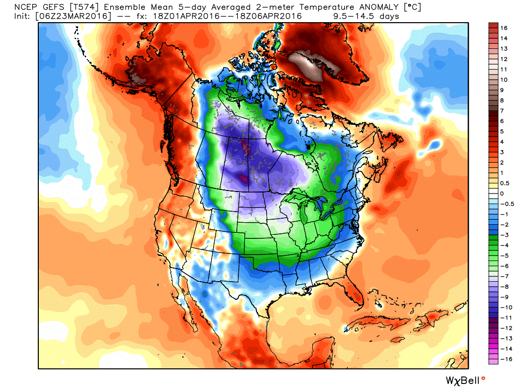
This pattern will have a strong effect on temperatures for the first week of April, as this map of temperature anomalies (i.e., the difference from normal) shows. Warm air builds in across B.C. and into Alaska (shades of orange and red), underneath the influence of the ridge. Meanwhile Arctic air takes hold across much of the territory east of the Rockies (shades of green, blue, and purple).
The areas taking the brunt of the cold air, across Saskatchewan, Manitoba, and western Ontario will see temperatures more than ten degrees below seasonal (purple) for the first several days of April. The cold won’t be limited to the Prairies however, with widespread areas averaging more than three degrees below seasonal (green), including southern Ontario.
In Atlantic Canada, warm temperatures will linger a bit into the beginning of April, but the cold air will eventually spread as far as the Atlantic coast as we move a few days into the month. With cold air in place across much of the east, and an active storm track likely to continue, we’ll be keeping a close eye on any storms that develop in the first weeks of April, which would have the potential to produce impactful winter weather in many regions that have gotten off relatively easy through the true winter season.
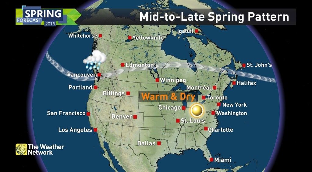
As we move later into the month of April, we don’t expect this pattern to persist. So after this parting shot from winter, true spring-like weather should take hold for good in the latter part of the month. This will include a warm and dry trend for the Great Lakes region, which should carry us all the way into early summer.


