PHOTOS: Heavy snow and hail as spring shows signs of confusion in Alberta

Sections of central Alberta experienced all weather types and seasons on Tuesday, as sections of the eastern Prairies gear up for another high impact 'spring' storm late week.
Mother Nature is refusing to let the Prairies get on with the spring season this week, with multiple rounds of snow pushing through, and hefty totals piling up.
MUST SEE: Spring says 'NO' to much of Canada this week
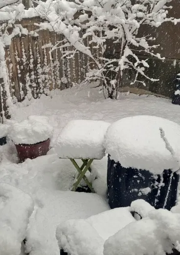
On Tuesday, a convective clipper system brought winter-like conditions back to southern and central Alberta, with a very localized narrow band of heavy snow locking in for several hours over Calgary's northern sections. That prompted a snowfall warning late Tuesday night for the city and surrounding areas, as 10-20+ cm was forecast to fall. Drivers were being warned to prepare for quickly deteriorating conditions, and the Calgary International Airport reported that some flights were delayed.
As of 6 p.m. MST Tuesday, Calgary airport had already received 13 cm, enough to break a daily record for April 19, which was 12.4 cm from 1985. Meanwhile, Edmonton had picked up 5 cm at that time, with more expected to fall through the overnight hours as well.
The intense bands of snow will subside and be all but gone from Alberta on Wednesday afternoon, then dissipating in Saskatchewan and Manitoba as well, as the low pushes into northwestern Ontario. In all, Edmonton to Red Deer may end up with 5-10+ cm of snow, with localized spots exceeding that amount spilling east of these cities into Saskatchewan.
On average, Edmonton typically sees about 14 cm of snow throughout the entire month of April.
WAITING FOR SPRING? WHEN YOU'RE IN ALBERTA SNOW IS SPRING WEATHER
It wasn't just the snow that contributed to Tuesday's wild spring weather day either. Just northwest of the winter wonderland, the town of Drumheller, Alberta experienced glimpses of summer-like conditions as well.
A gustnado was captured, as swirling air under the low pressure system kicked up sediment of the dry landscape. Isolated thunderstorms, lightning and hail persisted and accumulated on the roadways, disrupting travel in the region as well.
Here's a closer look at Tuesday's changing conditions that we're captured, as parts of the eastern Prairies now gear up for another high impact "spring" storm late week.
Thumbnail image courtesy: Cara Fraser/Twitter