
Brace for tricky Friday travel as widespread snow hits Ontario, risk of 10+ cm
Drivers beware: This first official weekend of spring could start with some heavy snow across parts of Ontario
Winter travel is being put to the test this week, as rounds of snow take aim at Ontario, just as the official spring season gets underway.
Lake-effect snow squalls took the stage on Wednesday, bringing hazardous conditions to roads and major highways. Those squalls will continue to impact the snow belt regions through the first half of Thursday, before the next system, a Colorado low, brings a more widespread snow threat to kick off the weekend.

The low will move into southwestern Ontario first, spreading across the Greater Toronto Area (GTA) by the afternoon. The heaviest snow from this system will be poorly timed with the Friday evening commute, so be sure to check your local road conditions before heading out, and be weary of rapidly deteriorating roads.
SEE ALSO: April 8 solar eclipse is the must-see celestial event this spring
Friday into Saturday: Widespread swath of snow with difficult travel likely
The snow will spread from west to east across Ontario during the day on Friday, continuing through the evening and into Friday night. With colder air already in place, this will help to offer greater snowfall chances as the low moves across the region.
The snow will become heaviest by the evening commute as the low deepens, although the exact storm track will ultimately determine total snowfall amounts. A shift north may allow warm air close to the border to surge north, possibly bringing a period of rain, which would significantly reduce the snow amounts in some areas. The current forecast shows this as an all snow event, but also with the warm air interruptions not far away.

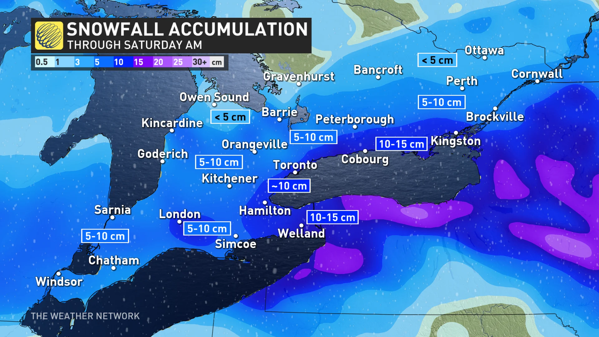
The Golden Horseshoe and Niagara, specifically, will likely see the heaviest of the snow as the low picks up moisture from Lake Erie to the south and tracks through the region. Folks here could see around 10 cm of snow fall on Friday before the system leaves the province by Saturday morning.
Some of the snow will melt on pavement, but untreated surfaces will become icy and snow-covered during Friday evening, with impact to travel likely especially as the sun sets and into the night.

There is still some uncertainty for southwestern Ontario, and near the north shore of Lake Erie, where mixed precipitation could result in minimal snow totals, including for the Windsor area.
The lowest confidence for snow is across eastern Ontario, and the Ottawa area, as some computer models keep the system further south, with less than 5 cm likely for the region.
DON'T MISS: Mild winter to blame for early pollen release in southern Ontario
Beyond the Friday snow, fair weather and chilly temperatures are forecast through the weekend and into early next week. Near seasonal temperatures are expected for the second half of the week, with a somewhat active pattern shaping up for the final few days of March and into the beginning of April.
Stay with The Weather Network for more forecast details and updates for your weather in Ontario.