El Niño’s final stand: Mild but moody spring weather across Canada

Wet and cold or dry and warm? Find out what the next few months have in store in The Weather Network's exclusive 2024 Spring Forecast!
What an extraordinarily mild winter it has been across Canada! Or should I say, what a lack of winter there has been?
While this past winter did include some memorable weather, including a monumental snowstorm for Atlantic Canada, a stretch of severe cold across western Canada, and a snowstorm that finally hit Edmonton, there is no question that El Niño stole the show with one of the warmest winters on record and minimal snow for most Canadians.
The question now is: will this mild pattern continue through spring?
Please read on to see what we expect across Canada during the months of March, April, and May.
National Spring Overview
Spring in Canada is known for its flip-flopping weather patterns as we move from winter to summer.
This season, though, we anticipate even more dramatic temperature swings and bursts of winter-like conditions disrupting the path to consistent warmth.
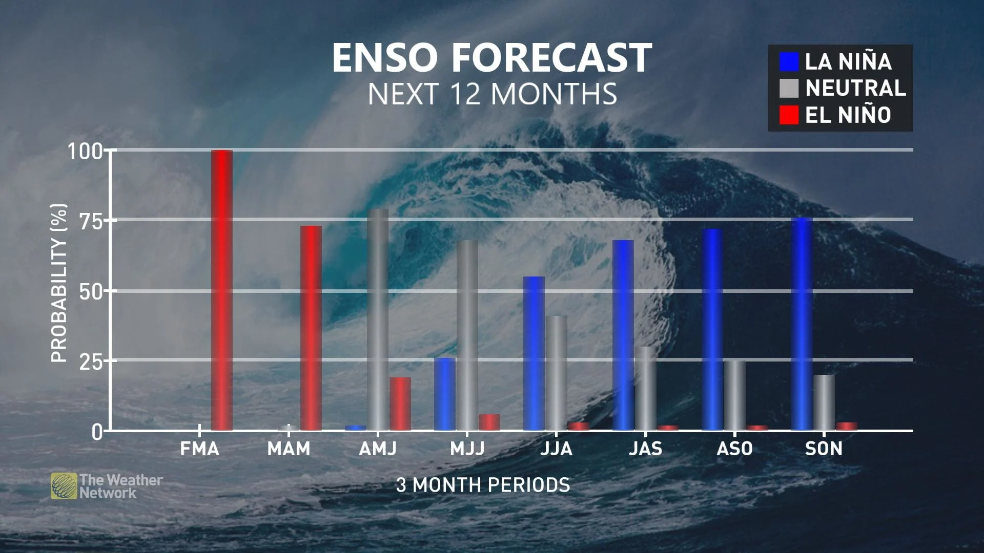
The reason? Once again, El Niño will be to blame, but for a different reason this time around.
Although a notable El Niño event remains active, it is beginning to diminish and will soon dissipate. At the same time, preparations are underway for La Niña to emerge.
RELATED: El Niño is hanging strong—but a big change is on the way
This shift from El Niño to La Niña as the primary influence on global weather patterns, occurring during a traditionally turbulent season, suggests that the upcoming season will lack a clear and stable character.
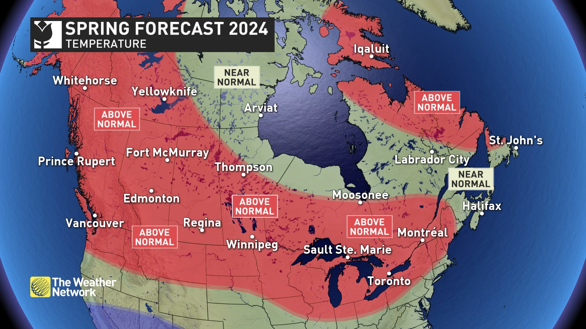
On the whole, we expect that above-average temperatures will predominate over cold conditions for the majority of Canadians in the upcoming spring, with the exception of eastern Canada, notably Atlantic Canada, where stretches of warmth will be more closely balanced with chilly spells, leading to temperatures approaching normal levels.
SEE ALSO: This spring will see the biggest cicada emergence since the 1800s
This forecast presents both good and bad news. The good news is that the mild winter and lack of snow will decrease worries about spring flooding. On the other hand, areas with a drier-than-normal winter may face an early start to the wildfire season.
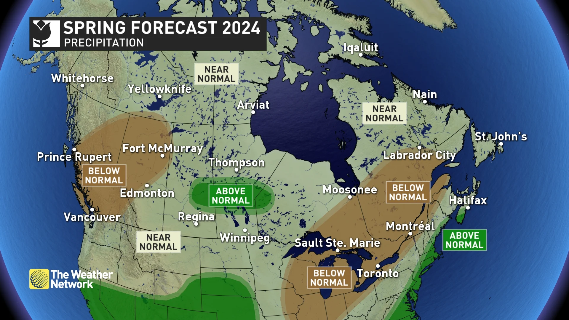
In terms of precipitation, while March is expected to bring about wet and stormy conditions, there are early indications pointing towards a shift to drier weather across significant portions of the nation as we approach the summer months. Of particular concern are the regions spanning British Columbia and northern Alberta, although our attention will also be focused on the area from the Great Lakes to the Gulf of St. Lawrence, where a dry weather pattern is anticipated in the latter part of the spring season.
DON'T MISS: Everything you need to know for April's spectacular and rare solar eclipse
A stormy weather pattern along the eastern U.S. and Atlantic Canada is set to persist into early April, leading to increased precipitation (above-normal) in southern Nova Scotia. Wet conditions could also develop in certain areas of the central and eastern Prairies during the month of May.
Below is a more detailed outlook on the spring weather ahead in your region.
Provincial Breakdown
British Columbia
March will start off cool and unsettled, with much-needed snow for the alpine regions, including the ski areas. However, as we get deeper into the season, we expect that warmer-than-normal temperatures and drier-than-normal conditions will dominate. This will give us even more days of pleasant spring weather than normal.
Spring flooding is less of a concern this year, with below-normal snowpack in the alpine regions.
However, there is a negative side to the pleasant spring weather. The below-normal winter snowpack and the above-normal spring temperatures will likely result in a shorter spring ski season. There is also a heightened risk of an early start to the wildfire season.
WATCH: Could the end of El Niño help ski season?
Alberta
Warmer-than-normal temperatures are expected to dominate the season, with a reduced risk for spring flooding due to the below-normal snowpack across the region, including the Rockies.
However, the temperature patterns are expected to be even more changeable than normal, with periods of colder-than-normal temperatures and a risk for a few high-impact, late-winter-like events that will interrupt the mild pattern at times. Drought continues to be a major concern for much of the province, and wildfires will be an increasing concern late in the season.
Saskatchewan and Manitoba
Spring is notorious for its wild swings in temperatures as we make the turbulent transition from winter to summer. This spring is expected to feature noteworthy periods of warmer than normal weather that will be interrupted at times by significant periods of colder weather, which will include a few high-impact late-winter-like storms.
After a mild winter with limited snowfall, the risk of spring flooding is lower than normal. Drought continues to be a major concern for parts of the region, and smoke from wildfires will be an increasing concern as we head towards summer. However, we are cautiously optimistic that the pattern will become wetter during May, especially for the central parts of the region.
WATCH: How this temperamental season will impact flood risk across the Prairies
Ontario
Spring weather started very early this year, and that is a preview of what is to come. We expect that warmer-than-normal temperatures will dominate the season.
However, the mild spring will be moody at times with periods of colder-than-normal temperatures and a risk for significant late-winter-like weather, which will test our patience as we wait for more consistent warm weather.
The mild winter followed by an early spring means that spring vegetation, including blossoms, etc., should come out ahead of schedule. Unfortunately, though, a warm spring does not eliminate the risk of late-season shots of cold weather. Therefore, we have a significant risk for a late-season frost or freeze after the start of the growing season.
While an active pattern is expected during March, we are concerned about the potential for increasingly dry conditions to develop during the second half of the season.
WATCH: Dry pattern could impact agriculture and ski season across Ontario
Quebec
Mild spring-like weather arrived very early this year, and we expect that warmer-than-normal temperatures will dominate the season.
However, our mild spring pattern will be interrupted at times by periods of colder weather (including a risk for messy late-winter-like storms), which will test our patience before we finally see the arrival of more consistent warm weather.
The mild winter followed by an early spring means that spring vegetation, including blossoms, etc., should come out ahead of schedule. Unfortunately, though, a warm spring does not eliminate the risk of late-season shots of cold weather. Therefore, we still have a risk of a late-season frost or freeze after the start of the growing season.
An active pattern is expected during March, but we are concerned about the potential for increasingly dry conditions during the second half of the season.
WATCH: Why you shouldn't count winter out too soon in Quebec
Nova Scotia, New Brunswick and P.E.I.
Flip-flipping temperature patterns should come close to offsetting each other during the spring season, resulting in near-normal or slightly above-normal temperatures. Below-normal winter snowpack across New Brunswick should result in less spring flooding than we often see.
An active storm track is expected to continue through March and possibly into April (with the typical threat of high-impact late-winter weather) before a drier pattern develops for the second half of the season.
WATCH: Dramatic temperature swings stretch through the season across Atlantic Canada
Newfoundland and Labrador
Changeable temperature patterns should come close to offsetting each other through the spring season, resulting in near-normal or slightly above-normal temperatures for the season. Above-normal temperatures are most likely across the northern parts of Newfoundland and Labrador.
However, residents of this region know all too well that high-impact winter weather is a normal part of the spring season, and this year will not be an exception.
An active pattern is expected during March and into April, but a drier pattern is expected during the second half of the season, resulting in near-normal precipitation for the season.
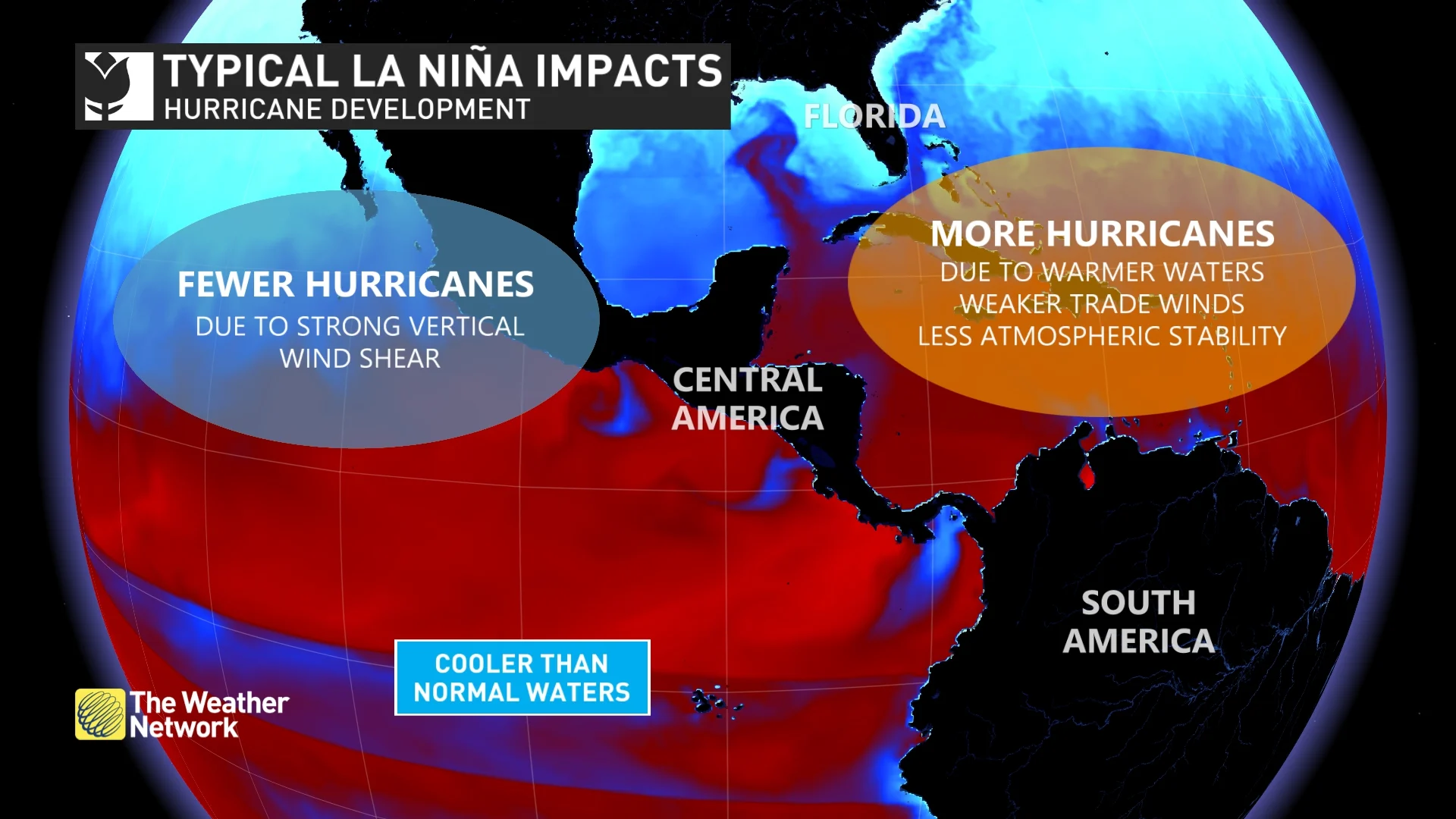
Overview of what a La Nińa year typically means for hurricane development. (The Weather Network)
Northern Canada
Warmer-than-normal temperatures are expected for most of the region, including the Yukon, much of the Northwest Territories, and Baffin Island. Meanwhile, near-normal temperatures are expected for the western parts of Nunavut. Near-normal temperatures are expected for most of the region.