Ontario: Summer's grand finale set to bring a 30 degree October day

Soak up the heat. Tuesday will be the last hot day of the year in Ontario.
A bit of confusion over exactly what season it is can be forgiven, as behind us is a relatively chilly weekend and ahead is potentially record-breaking temperatures on Tuesday. As toasty as it looks set to get, the heat will be short-lived, with temperatures dropping beneath a cold front passing through later Tuesday that will also raise the risk of storms producing torrential downpours. more details, below.
Visit our Complete Guide to Fall 2019 for an in-depth look at the Fall Forecast, tips to plan for it and a sneak peek at the winter ahead
WEATHER HIGHLIGHTS:
Above-seasonal temperatures on Tuesday with soaring humidity
Thunderstorms linger in the east Tuesday morning, ahead of a more widespread second round later Tuesday
Strong cold front sinks south by Wednesday with a widespread frost threat on Friday
Stay aware of ALERTS in your area
WATCH BELOW: TIMING THE RAIN AND STORM RISK THROUGH TUESDAY
We are about a week into the fall, but Ontario's weather apparently did not get the memo, as a surge of warmth is about to send the province's temperatures soaring to levels more suited to July and August rather than the doorstep of October.
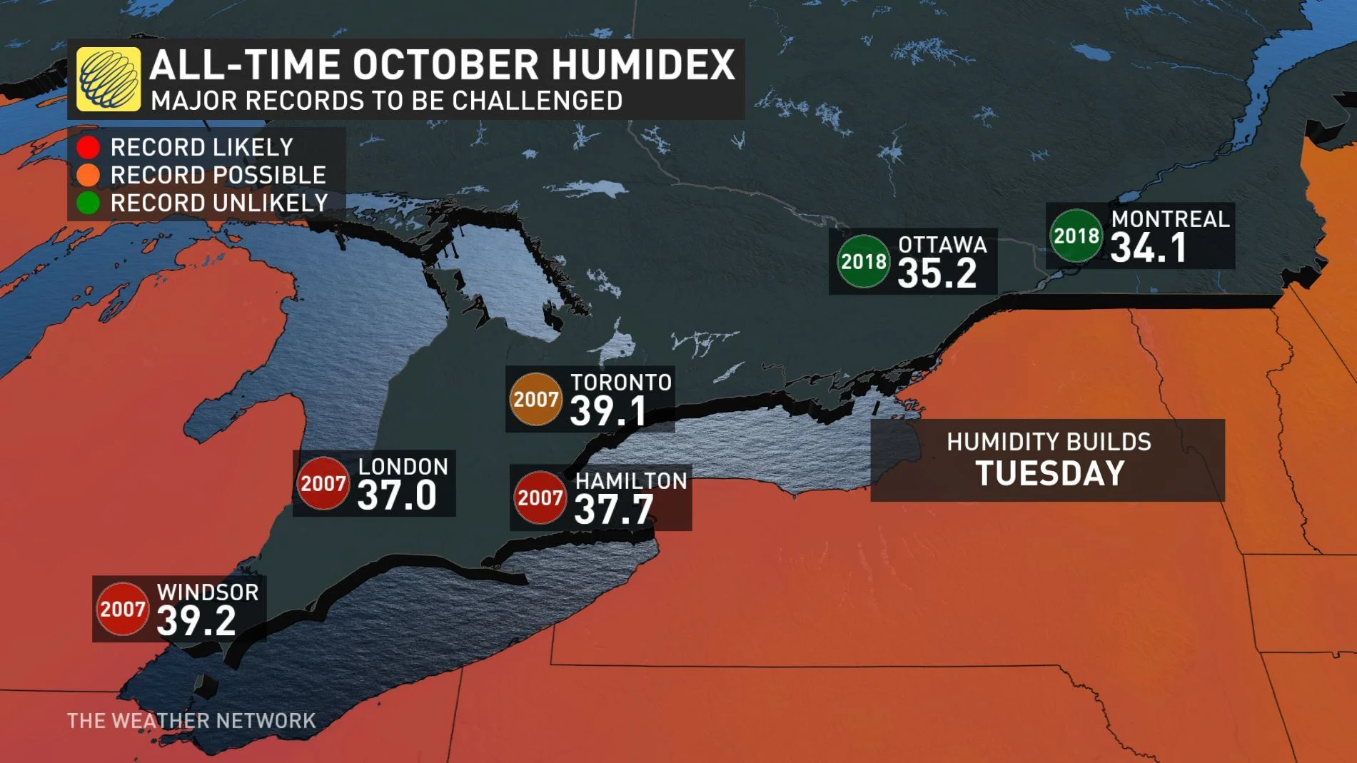
"Tuesday will be hot and humid with high temperatures in the upper 20s to near 30°C and a humidex into the upper 30s," Weather Network meteorologist Dr. Doug Gillham says.
That is, indeed, on the hot side for the season, and so far above the average that both daytime highs and associated humidex values are in danger of inching over the line into record territory.
MUST-SEE: Schools close amid dangerous, record-breaking snowstorm
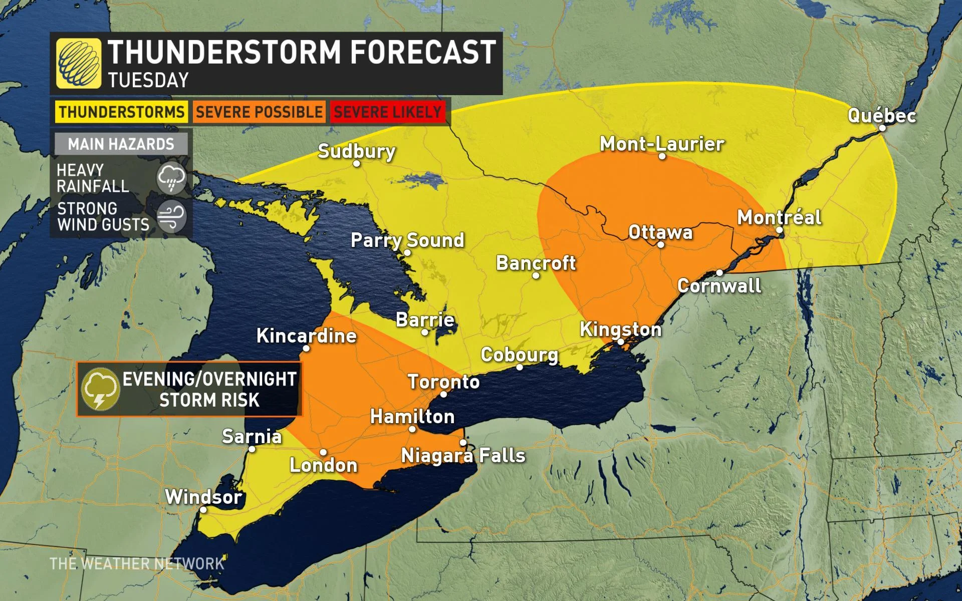
That kind of heat and humidity are key ingredients in thunderstorm formation, and in fact different parts of the province are in line for that threat Tuesday as the same low-pressure system that brought record-breaking September snows to the Prairies tracks eastward far to the north.
The system has already brought rain to parts of Ontario north of Lake Superior, and showers are still possible in eastern Ontario Monday morning as it continues onward.
Later in the day, the cold front sinks southward, cutting through the humidity and potentially triggering a new round of storms, beginning in the southwest. In terms of severity, forecasters say the biggest risk will be heavy rainfall, and with storms clustering together there's some chance of "training," which is when one storm follows another above a particular area in quick succession, drastically boosting rainfall totals.
That cold front will then usher in a surge of much cooler air through the mid-week mark, making Tuesday the last hot day of this year.
"Many areas will likely see the end to the growing season through Thursday and Friday night as we will have a widespread frost outside of urban/suburban areas," Gillham warns.
By Saturday, daytime highs will struggle to even hit the mid-teens.