Prairies: Schools close amid dangerous, record breaking snow storm

Travel conditions remain poor across southern Alberta as snow continues to accumulate with reduced visibility in blowing snow.
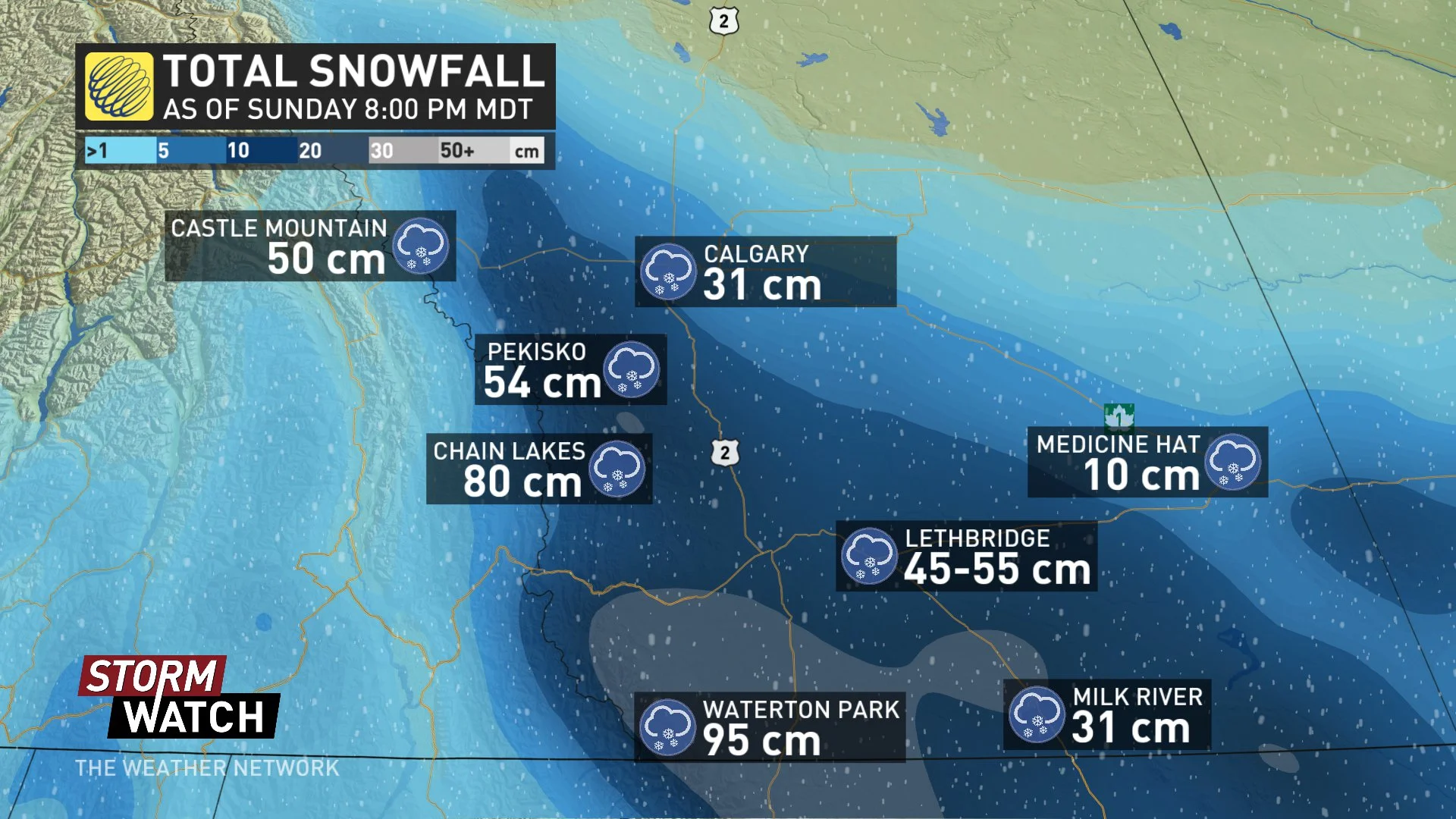
The final weekend of September looked a lot more like mid-winter across southern Alberta and Saskatchewan, and the snow isn't over yet. Some spots are already buried in drifts a metre deep, with some lingering snow persisting into Monday. Gusty winds have also made travel dangerous in blizzard-like conditions across much of the region, prompting the RCMP to discourage travel, even on major roadways. We look at what's fallen so far, and what's still to come, below.
WEATHER HIGHLIGHTS
Moderate snow continues across the region through Monday afternoon
Strong wind gusts spur blizzard-like conditions
Hazardous travel conditions across southern Alberta/southern Saskatchewan; postpone non-essential travel
Stay up-to-date on the ALERTS in your area
WATCH BELOW: TIMING THE STORM THROUGH MONDAY
IN PHOTOS: Incredible snowy scenes in Alberta as record-breaking snow continues
The calendar may still say September, but you wouldn't be able to tell across much of southern Alberta and Saskatchewan. Sunday was another long, snowy day, not just in extreme southern Alberta, but as far north as Red Deer and Saskatoon, and as far east as Regina by Sunday evening, as a Colorado low south of the border funnelled additional moisture into the region.

In addition to official snowfall totals from Environment Canada, amounts in excess of 50 cm were being reported by residents in Lethbridge by early Sunday evening, with 20 to 25 reported in southwestern Saskatchewan. Even further south in Alberta, Waterton Park reported 100+ cm of snow locally by Monday morning.
The City of Calgary, although not one of the hardest hit areas, broke its all-time September daily snowfall record on Sunday (September 29th) after 24.6 cm of snow fell, making it the snowiest September day for the city.
Heavy, wet snow started to bring down tree branches across parts of southern Saskatchewan by Sunday afternoon. SaskPower has reported outages in the Assiniboia area due to downed power poles, while area residents took to Twitter to report power outages in Moose Jaw.
TREACHEROUS ROADS, TRAVEL DISCOURAGED
Travel in southern Alberta was treacherous on Sunday, with officials urging drivers to keep off the roads if at all possible through Monday.
"Hwy conditions throughout southern Alberta are currently poor with snow continuing to accumulate and reduced visibility," 511 Alberta tweeted early Monday. "Conditions are expected to deteriorate further into Monday morning. Avoid all non-essential travel until conditions improve."
By Monday morning, police say winter weather factored into over 300 collisions in Calgary, with the biggest occuring at Beddington Trail and Deerfoot Trail, where 16 vehicles were involved. Police in Medicine Hat were also advising drivers to keep off the roads if at all possible on Sunday evening.
The heavy snow has also contributed to a number of flight cancellations with officials warning travellers to leave plenty of extra time.
SNOW LINGERS THROUGH MONDAY
Snowfall will begin to ease through Monday afternoon for southern Alberta, though Monday morning commutes were still quite the challenge for many. Some southern Alberta school boards were already reporting closures by Sunday evening and the University of Lethbridge also announced via Twitter that it will be closed on Monday. The winter storm and snowfall warnings that were issued for the region have now been dropped.
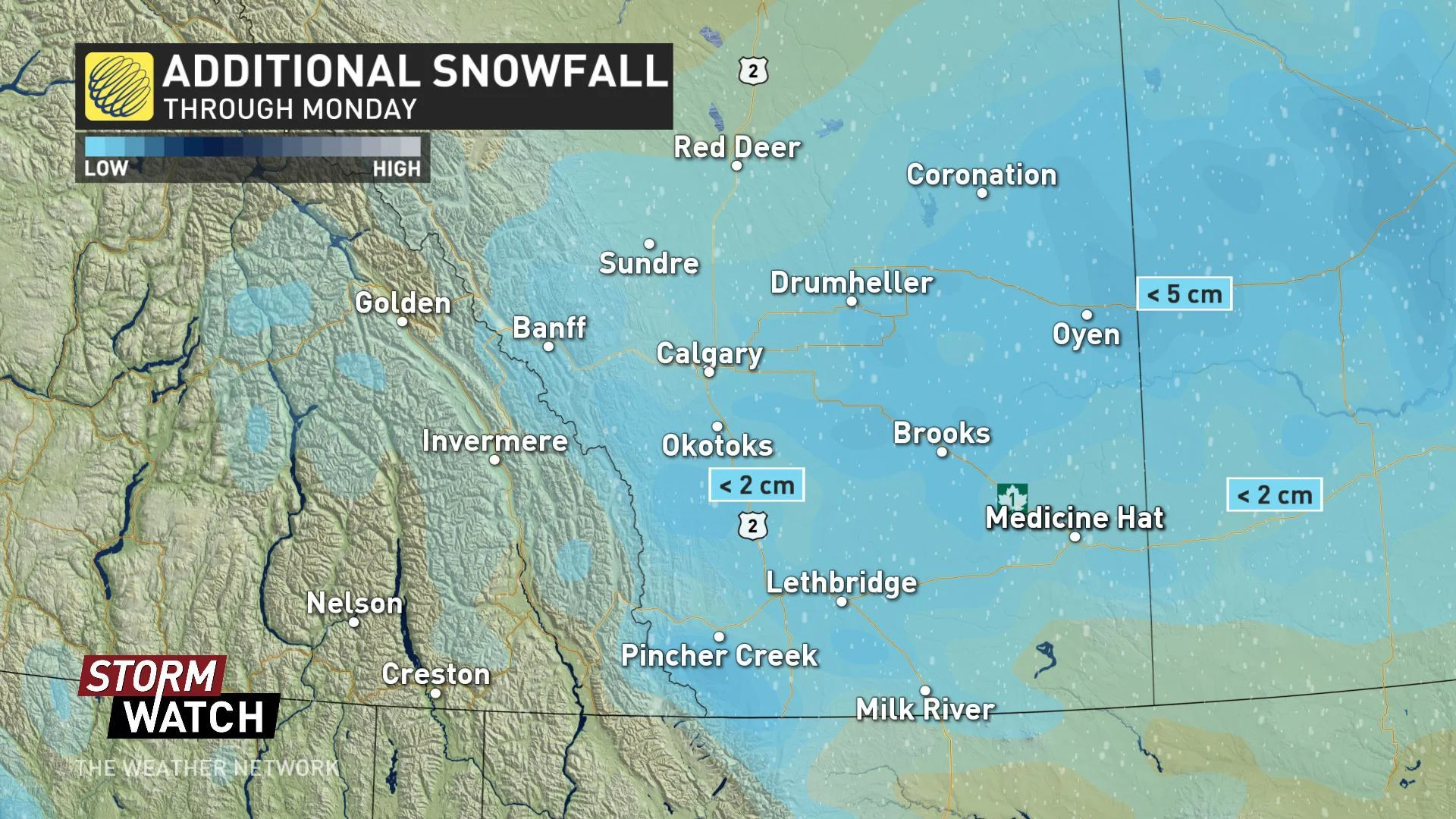
Snow will lift north across southern Saskatchewan into early Monday, with some mixing of rain and snow possible before precipitation turns back to snow for Monday afternoon. Snow will taper off there through Monday evening.
"This very cold pattern will relax a bit through midweek, but temperatures remain below seasonal this week and into the weekend across southern areas," says Weather Network meteorologist Dr. Doug Gillham.