PHOTOS: Waterspout spotted in southern Ontario as hail blankets lawns

The unsettled weather tracked through Grey Bruce county and the GTA.
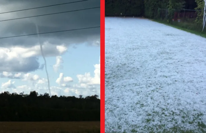
Southern Ontario saw unsettled weather on Thursday afternoon that featured isolated thunderstorms, strong wind gusts, and hail. Photos show that some areas, such as the Grey Bruce county and the GTA, quickly saw hail accumulating and blanketing lawns.
"A cold front tracked through the Grey Bruce county, which triggered passing showers before it cut through an unstable air mass. Strong updrafts occurred in locally stronger thunderstorms and all of these conditions contributed to the formation of hailstones," explains The Weather Network meteorologist Jessie Uppal.
West of the storm where skies were clearer, a waterspout formed near Goderich. This waterspout formed along the dark flat base of a cumulus cloud during relatively calm weather and was non-severe, unlike the tornadic waterspouts that develop during thunderstorms which can be dangerous.
The U.S. National Weather Service says that the best way to avoid a waterspout is to move at a 90-degree angle to its apparent movement and to never move closer to investigate since they can be just as dangerous as tornadoes.
See below for a look at the active weather that passed through.

Submitted by Jamie DeVries and captured south of Goderich, Ontario.

Submitted by Mike Gvildys and captured in Owen Sound, Ontario.

Submitted by Sheila Siegrist and captured in Owen Sound, Ontario.

Submitted by Mike Gvildys and captured in Owen Sound, Ontario.

Submitted by Sheila Siegrist and captured in Owen Sound, Ontario.

Submitted by Mike Gvildys and captured in Owen Sound, Ontario.

Submitted by Sheila Siegrist and captured in Owen Sound, Ontario.