Summer hits the pause button across Canada

Given Canada's size, it's tough to have the entire country experiencing the same weather pattern. The first half of June looks to be doing just that, maybe not in such a good way for many.
June 1 marked the official start to meteorological summer, and in true Canadian fashion, there will be very little true summer-like weather to come in the weeks ahead.
"Summer hits the pause button!" says Dr. Doug Gillham, a meteorologist at The Weather Network.
Visit our Complete Guide to Summer 2022 for an in-depth look at the Summer Forecast, tips to plan for it and much more!
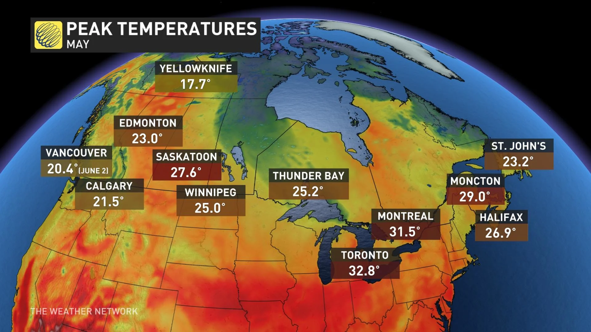
Parts of Canada saw mid-summer-like heat and humidity and even record breaking temperatures at times during May, but now that it is June, hot weather will be absent across Canada for at least the next two weeks.
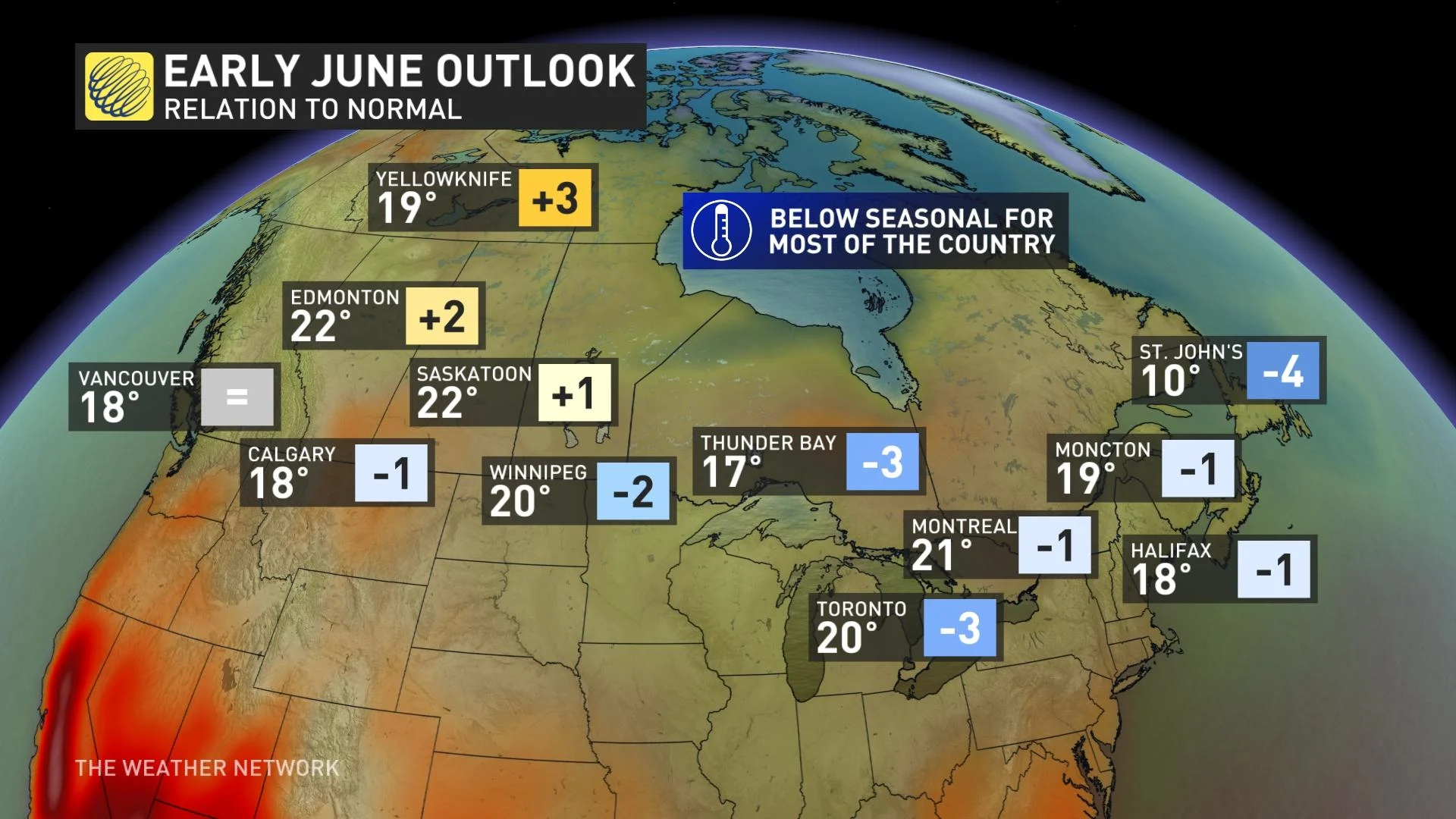
For much of Western Canada, this means that a cooler than normal pattern will continue to dominate during the next few weeks. However, northwestern and northern parts of the country will enjoy stretches of warm and dry weather.
Across Ontario and Quebec, a cooler pattern is expected, with no heat or oppressive humidity in sight for the next two to three weeks. For Atlantic Canada, summer will struggle to hit its stride over the next couple weeks, though that is nothing out of the ordinary for June across this region.
"So, as we look across Canada, no truly hot weather is in sight through at least the first two to three weeks of June," Gillham says. "According to the calendar it is still spring and for most Canadians, the next couple weeks will certainly feel more like spring."
Here's a closer look at how June starts across the country.
BRITISH COLUMBIA
Vancouver finally reached 20 degrees (ever so briefly) for the first time this year on Thursday, but as we head into the weekend a cool and unsettled pattern will resume across the region. A few days of drier weather are likely early and mid next week, but it looks like the pattern will turn unsettled again late next week and weekend. Temperatures will continue to trend cooler than seasonal, as well.
PRAIRIES
The western Prairies will see mostly sunny and pleasant conditions to start the weekend and warm weather will continue across northern Alberta well into next week. However, southern parts of Alberta will turn cooler starting Sunday, with a couple rounds of much needed rain for much of southern Alberta and southwestern Saskatchewan through early next week.
Meanwhile, rather chilly weather will hang on across the eastern Prairies. In fact, there will be a few nights with a risk for frost and localized freeze conditions through Monday.
MUST SEE: True to style, Canada starts meteorological summer with heavy snow
"The good news is, we'll see a much needed extended stretch of drier weather for the eastern Prairies for the next week," Gillham says. "However, the chilly pattern means that it will take longer for the fields to dry out and slow the progress of the growing season."
RELATED: Another Colorado low is frustrating Manitoba farmers who can't seed their fields
ONTARIO AND QUEBEC
A reinforcing shot of cooler weather will arrive this for the weekend with the threat for frost for parts of northern Ontario and into parts of Quebec. The cooler than seasonal conditions will persist through next week and into the following week, as well.
Northwestern Ontario will finally get a break from the excessively wet pattern that has dominated the past couple of months. Meanwhile, a couple of systems will track across southern Ontario and southern Quebec next week, bringing a few periods of rain, but we will also see some sunshine between systems.
While no hot weather is in sight for the first two to three weeks of June (quite a contrast to what we saw at times during May), the first half of the month will still bring periods of pleasant weather for most outdoor activities and there are signs that a warmer pattern will return before we get to the end of June.
ATLANTIC CANADA
As goes the theme for the rest of the country, the cooler than seasonal temperatures will be prominent across the Maritimes through the weekend and into the beginning of next week.
Temperatures will trend closer to seasonal across the region for the middle of next week, but no hot weather is in sight. However, we are closely watching a tropical system that will track offshore of the U.S. East Coast during the week. At this point, the storm is expected to stay well out to sea, but we can’t completely rule out some minor impacts from the remnants for parts of Newfoundland.
TROPICS: Florida braces for flash flooding as tropical system eyes landfall