Florida braces for flash flooding as tropical system eyes landfall

The first storm of the new Atlantic hurricane season is on the cusp of developing mere hours after experts increased the number of storms they expect this year.
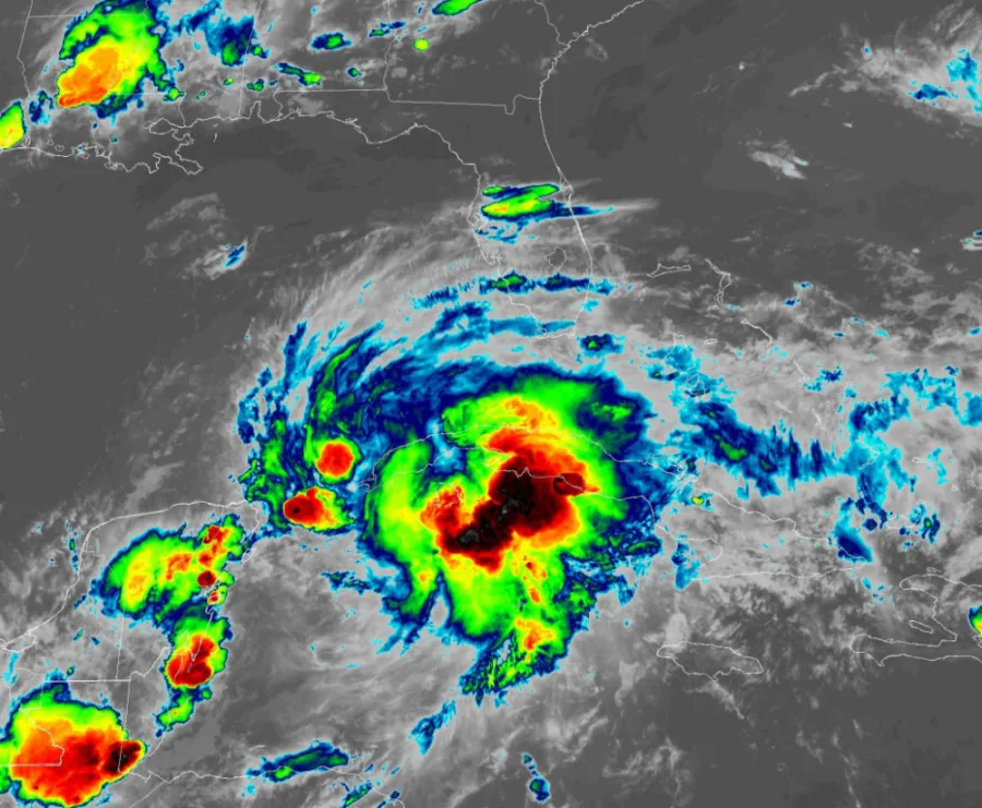
All eyes are on the Gulf of Mexico as the first tropical system of the 2022 Atlantic hurricane season is brewing off Mexico’s Yucatan Peninsula. The system will drift over Florida through the weekend, bringing flooding rains and a threat for tornadoes to the southern part of the state. We have to closely watch the system’s track as it enters the western Atlantic. More on what the storm will bring the Sunshine State, below.
SEASON’S FIRST STORM BREWING IN THE GULF OF MEXICO
This year’s hurricane season is only a few days old, but we’ve already got the first storm of the year brewing in the Gulf of Mexico.
The remnants of Hurricane Agatha from the Pacific Ocean drifted across Mexico this week, emerging into favourable conditions over the southern Gulf of Mexico.
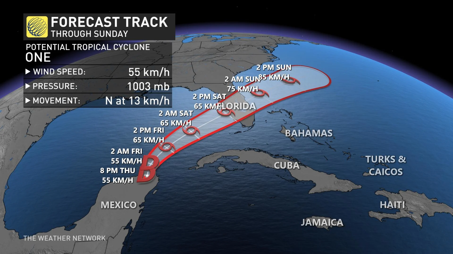
The U.S. National Hurricane Center (NHC) declared this tropical disturbance “Potential Tropical Cyclone One,” a technical designation that allows forecasters to begin issuing tropical storm watches and warnings for folks in harm’s way before the storm officially forms.
Forecasters with the NHC give the potential tropical cyclone a 90 percent chance of developing into a tropical storm during the day on Friday. Once (and if) this system develops, it’ll earn the name Tropical Storm Alex.
Tropical storm watches are in effect for the southern half of the Florida peninsula, including the cities of Miami, Key West, Melbourne, and Sarasota. Tropical storm conditions could begin across these areas on Friday and last through Saturday.
FLOODING RAINS WILL POSE THE GREATEST HAZARD TO FLORIDA
As we see with many early-season storms, the big story with this tropical disturbance—whether it forms into a named storm or not—will be drenching rains for western Cuba, southern Florida, and The Bahamas.
We could see 100-200+ mm of rain falling across the southern half of Florida through this weekend, with the heaviest totals targeting the Florida Keys and the Miami metro area.

While this area is accustomed to tropical downpours, this much heavy rain falling in such a short period of time could lead to widespread flash flooding issues.
Heavy rains are far and away the greatest hazard with this system as it makes landfall. Even so, the threat for gusty winds and tornadoes will pose a hazard to communities across southern Florida.
The NHC’s latest forecast calls for this system to make landfall in western Florida as a tropical storm on Saturday afternoon with maximum sustained winds of about 70 km/h, which could lead to some tree damage and power outages.
As with any landfalling storm, the region will see a low-grade risk for tornadoes through the weekend.
If you’re vacationing in the area, check your phone’s settings to ensure emergency alerts are activated for flash flood and tornado warnings. If someone you know is in the area, get in touch and pass along the friendly advice to check that they’re ready to receive warnings the moment they’re issued.
EXPERTS INCREASE HURRICANE SEASON FORECAST
All signs point toward another active hurricane season this year.
La Niña conditions in the eastern Pacific and warmer-than-normal sea surface temperatures across much of the Atlantic basin may combine to lead to yet another above-average season over the coming months.

In light of the increasingly favourable conditions for tropical cyclone development, the experts at Colorado State University revised their seasonal outlook upward on Thursday.
The group’s much-anticipated forecast now calls for 20 named storms across the basin this season, with 10 of those storms strengthening into hurricanes, and half of those hurricanes growing into major category threes on the Saffir-Simpson Hurricane Wind Scale.
If the forecasts come to fruition, this would be the Atlantic basin’s seventh above-average hurricane season in a row. The last two seasons were among the most active on record. The 2020 hurricane season broke the record with a whopping 30 named storms, and the 2021 hurricane season ended as the third-most active season on record with 21 named storms.

There are 21 storm names assigned to the 2022 hurricane season. The list, which rotates every six years, begins with Alex, Bonnie, and Colin, continuing down the list until we reach Walter.
Thumbnail courtesy of NOAA.