Canada's warmest air will sit in the Arctic on Thursday

An Omega Block in Western Canada is delivering the warmest air in the country to the territories while snow makes an appearance in the south.
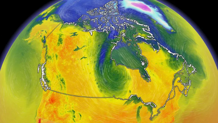
An omega blocking pattern is developing across much of Canada and will be good news for some, but bad news for most -- especially since blocking patterns mean that the same type of weather is repeated for days or even weeks.
Visit our Complete Guide to Summer 2022 for an in-depth look at the Summer Forecast, tips to plan for it and much more!
An upper low over Hudson Bay is what's responsible for the early June snowfall in northern Manitoba and will also drive the cooler air expected across most of Eastern Canada in the days to come.
MUST SEE: True to style, Canada starts meteorological summer with heavy snow

To the west, a ridge is stretching along the Rockies and into the Yukon, and this ridge will feed off Pacific and coastal air thanks to the second upper low that's sitting off the coast.
So who benefits?
Vancouver will finally have the chance to reach its first 20°C day of the year on Thursday, though the chance will be short-lived as temperatures drop again by Friday. If 20°C is not reached, the city will likely break the record for the longest wait for the first 20-degree day. The current record is June 10th.

The real winners of this pattern however, are in the north.
Whitehorse will be the warmest capital city in the country on Thursday, with a forecast high of 24°C.
The foothills in the Northwest Territories will be provided some downsloping warmth and will likely be the location for Canada's warmest temperature. The Mackenzie River Valley could also reach 30°C, only seven weeks after sitting at -20°C.

Watch the video above for a closer look at this pattern and the unusual spot for Canada's warmth on Thursday.