
Storm threat climaxes Friday as a cold front slices through Ontario, Quebec

In a week that's brought a confirmed EF0 tornado and several rounds of damaging storms, the thunderstorm threat will finally climax on Friday, making way for a pleasant and sun-filled weekend ahead. The cold front that will help to spark Friday's storms will also help to usher in some fresher air for the weekend, bringing relief from the high heat and tropical humidity that locked in for most of this week as well. In fact, temperatures will actually be a few degrees cooler than seasonal in some spots this weekend. More on Friday's storm threat, plus a look at some tropical moisture that forecasters are closely eyeing for next week, below.
FRIDAY: FINAL DAY OF HIGH HEAT AND THUNDERSTORM CHANCES
The hideous heat and humidity that engulfed southern Ontario for much of this week will finally be ushered out on Friday by an approaching cold front.
That same boundary however, will be a major factor in the severe thunderstorm risk as well, with the potential for a final round of storms that threaten heavy downpours, hail and gusty winds Friday afternoon and evening.
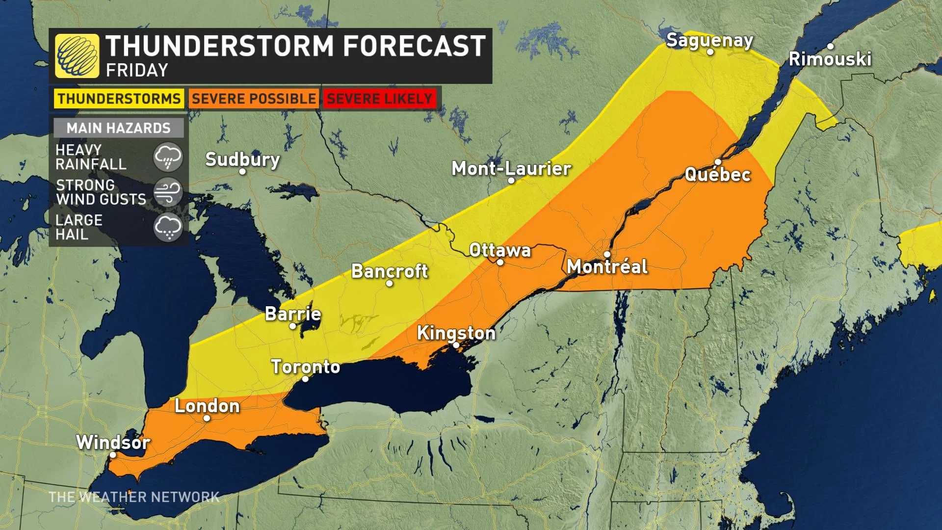
Ahead of the cold front, daytime highs will hover in the upper 20s, with a handful of places still staying above 30°C across southern Ontario. That humidity will keep it feeling like the mid to upper 30s.
A heat warning remains in effect for almost all of southern Quebec, where the humidex will be closer to 40 on Friday. Temperatures are set to fall closer to seasonal by Saturday and the remainder of the weekend.
"Watch for the effects of heat illness: swelling, rash, cramps, fainting, heat exhaustion, heat stroke and the worsening of some health conditions," warns Environment Canada in the warning.
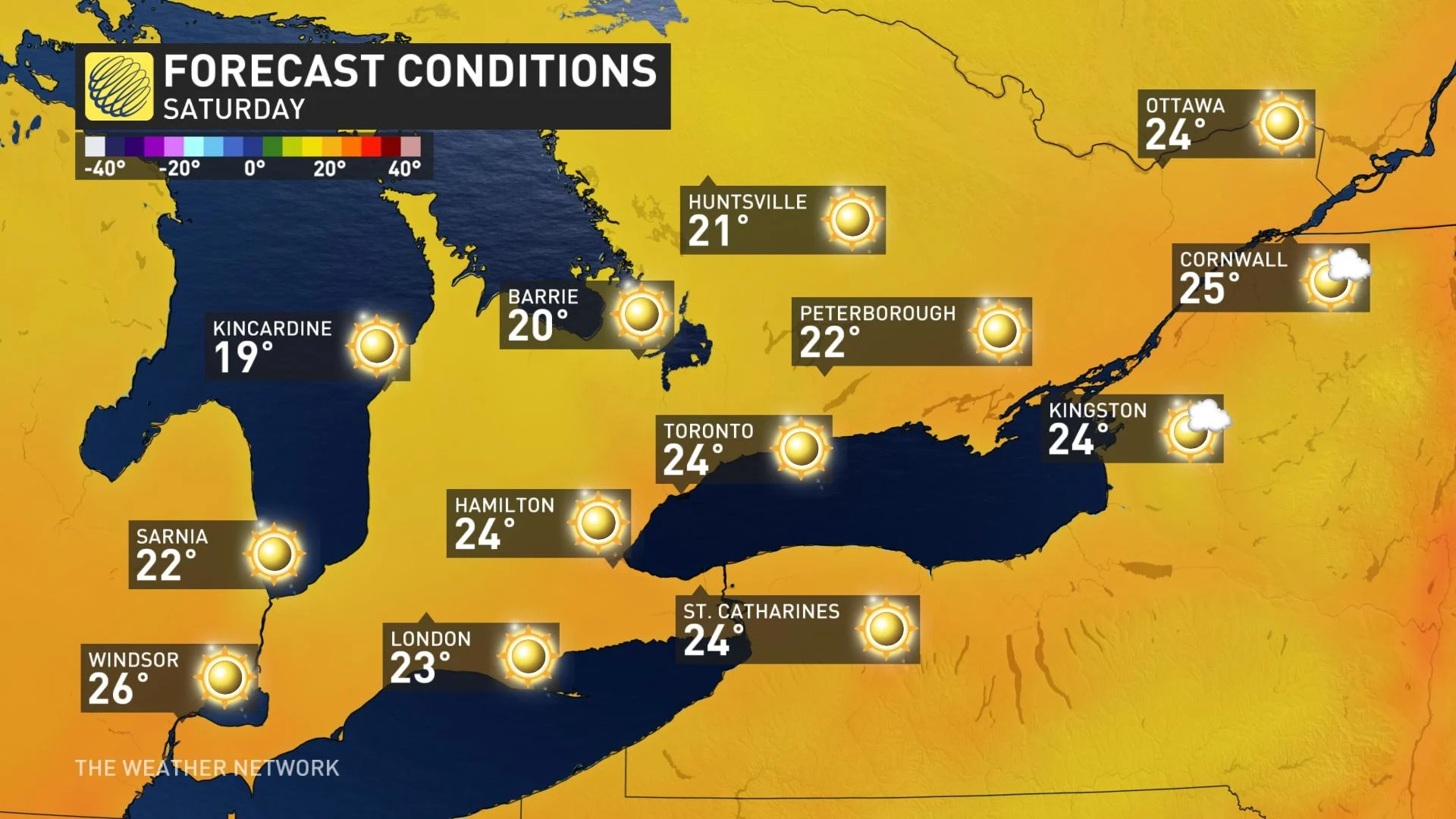
WEEKEND AND BEYOND: MUCH FRESHER AIR ARRIVES, EYES ON TROPICAL REMNANTS NEXT WEEK
Fresher air will pour into the region behind the front, as northwesterly flow takes hold. This will bring welcome relief from the heat and humidity as sunny skies and pleasant summer temperatures arrive for Saturday. Temperatures will actually be a few degrees cooler than seasonal in some places.
The pleasant weather continues into early next week, with mostly sunny skies and a warming trend expected to last through at least the mid-week mark. Forecasters are closely eyeing the impacts of a tropical system however, which could bring moisture into the region by late next week.
"Fred could complicate the forecast during the middle of next week," says Dr. Doug Gillham, a meteorologist at The Weather Network, adding that the overall pattern supports an extended period of very warm and dry weather for the region.
"However, if tropical moisture comes far enough north, then we will have an increasing risk for showers and thunderstorms for southern areas."
Check back as we continue to monitor the forecast in southern Ontario.
Thumbnail image courtesy: Rita Johnston, Goderich, ON


