
What if we told you that more Canadian provinces could see snow this week?

Nearly 100 centimetres of snow in September. It's a startling stat, but it also just happened across southern Alberta.
The historic weekend snow storm -- which actually fell on the first full weekend of fall -- has captured headlines for days, with both local residents of the Prairies in awe of this early wintry blast and also other fellow Canadians in denial that this sort of thing could (or should) happen in September. Especially when summer's grand finale is set to bring July-like heat and humidity into parts of Ontario Tuesday.
Visit our Complete Guide to Fall 2019 for an in depth look at the Fall Forecast, tips to plan for it and a sneak peek at the winter ahead
So, when asked the question on Twitter, "What if we told you that more Canadian provinces could see snow this week?," let's just say there was a lot of pleas for "NO." In fact, in a poll that also asked when the ideal month for the first snowfall would be, more than 60 percent of the 4,000 that voted said they'd be happy to wait until at least November.
But ready or not, it is now October with the chances -- although minimal -- slowly increasing as temperatures lock into a cooler and more autumnal pattern.
"There's actually more Canadian provinces that could possibly see some snowfall as the temperature pattern cools off in the east this week," says Weather Network meteorologist Kelly Sonnenburg.
WATCH BELOW: SYSTEMS COULD BRING SOME MIXING OR SNOW ACROSS EASTERN CANADA
Not to worry, this week's snow will be nothing like what parts of the Prairies saw over the weekend, but there are cool enough temperatures at play that could send some flakes flying across eastern Canada.
"A cooler air mass in place means that when systems do move in through the evening and overnight hours, there is the possibility of precipitation transitioning over to snow," Sonnenburg says, adding that forecast models show the most likelihood for some snow over northern Quebec and parts of western Newfoundland this week.
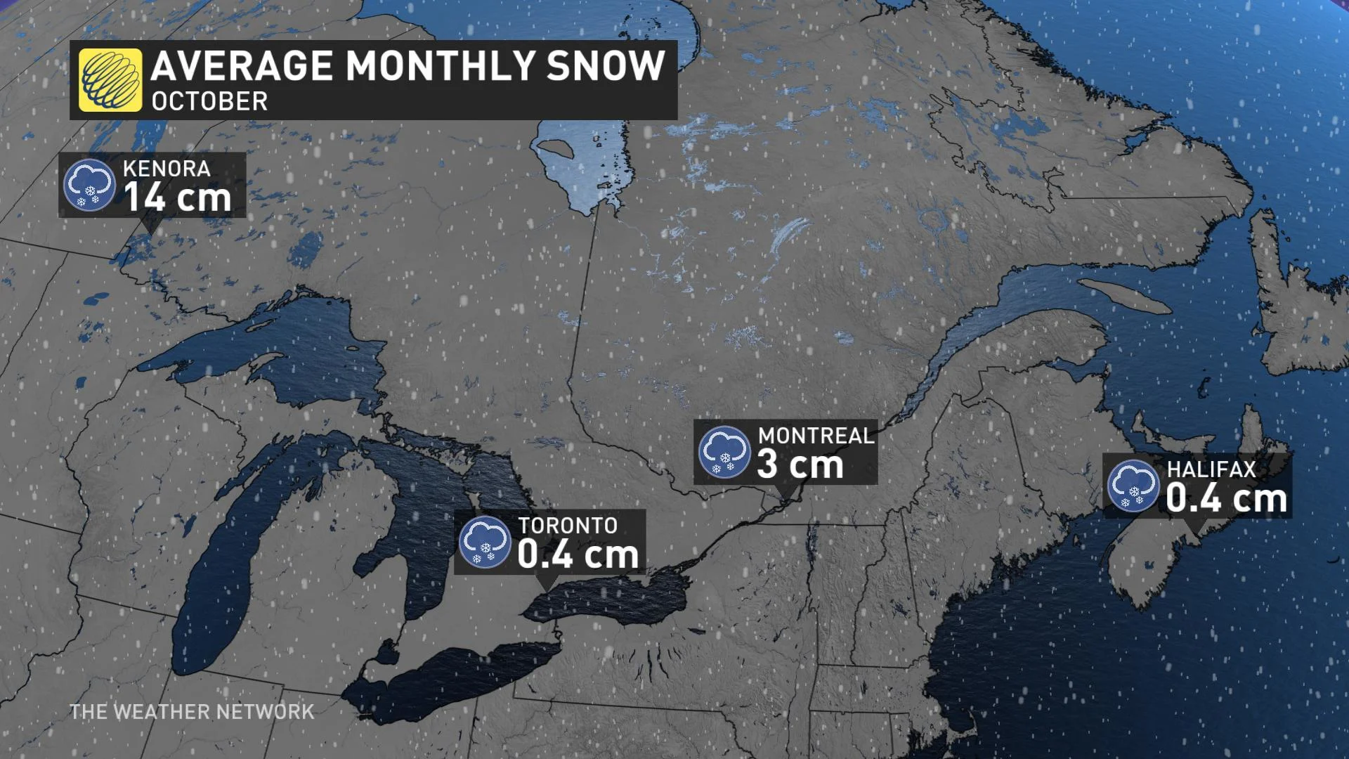
SEPTEMBER SNOWFALL NOT ALL THAT UNUSUAL, ESPECIALLY IN ALBERTA
While Alberta saw a huge amount of snowfall last weekend, it's not completely unheard of for the region to pick up September snow, especially with its proximity to the Rocky Mountains.
The higher in elevation you get, the colder the temperatures are, increasing the chance of seeing precipitation fall as snow instead of rain. Another factor is the orographic lift, known as the motion of rising air against a mountain range.
"For Alberta and the Rocky Mountains, when a general easterly flow in the winds travels across the Prairies, the air is forced to rise and cool along the mountains. The air condenses and then precipitates into snowfall, enhancing snow totals along the Rockies and into the foothills," Sonnenburg explains.
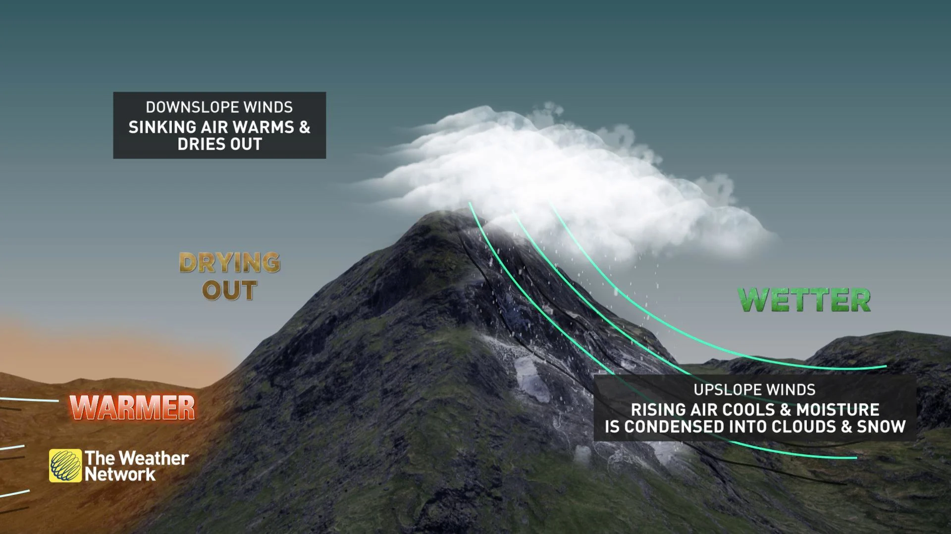
In the case of the weekend system, a low pressure system was travelling north from the U.S. into Canada, while at the same time, arctic high pressure was sinking in from the north.
"The general flow was easterly from the low and high and the upslope winds or orographic lift allowed snowfall to dramatically pile up across extreme southern Alberta," adds Sonnenburg.


