
FALL FORECAST: Your next three months, plus winter sneak peek

The Weather Network releases its official 2019 Fall Forecast, including an exclusive sneak peek at the 2019-20 winter season.
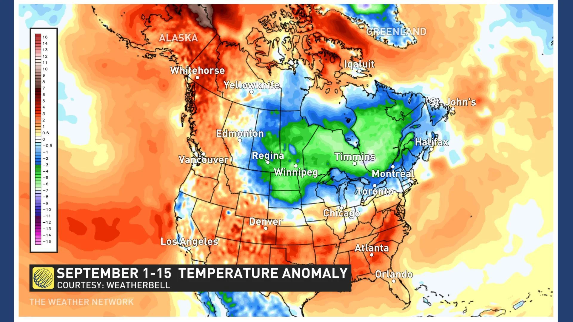
Ready or not, fall is here! After a short summer, fall has started quickly across most of Canada. The map below shows temperature anomalies for the first half of September. The various shades of blue and green highlight the regions where we have been colder than normal since September 1st.
Does this mean that winter is just around the corner?
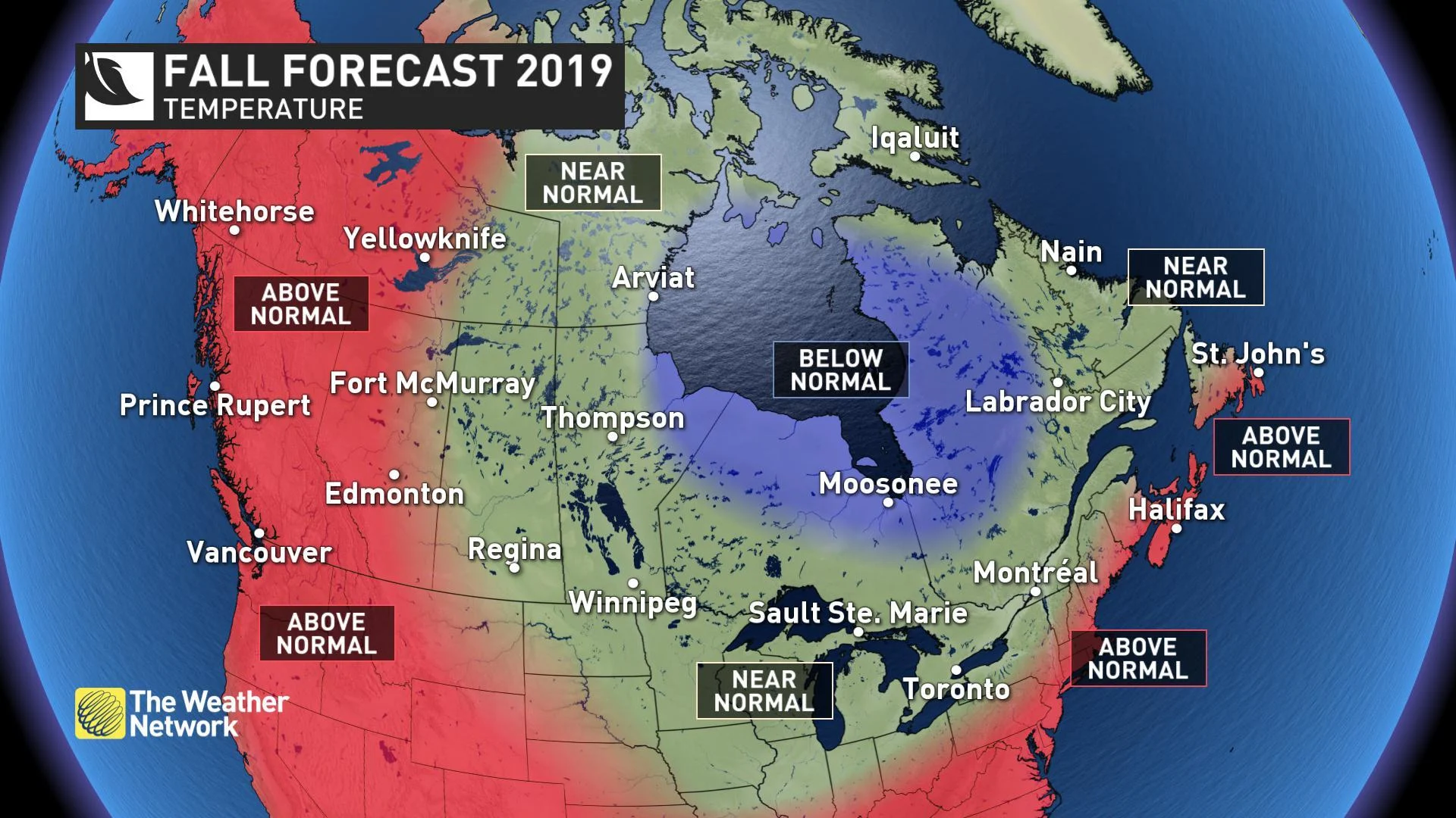
While fall has burst onto the scene long before most Canadians were ready, we are not in a freefall to winter. Across Canada, we will see extended stretches of pleasant weather before winter arrives. Most Canadians can expect typical fall weather during the next two and a half months with near-normal temperatures. However, across BC, Alberta, and southern parts of Atlantic Canada we expect that temperatures will tip to the mild side of normal.
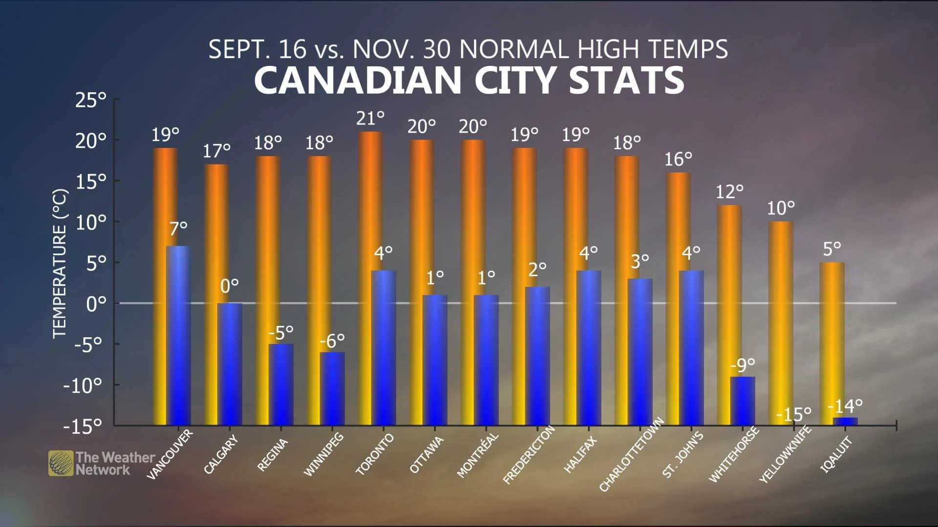
Keep in mind that during the fall season, "normal" temperatures change very quickly, especially across central Canada where normal temperatures drop by 2 to 3 degrees Celsius per week. The drop-off is not quite as dramatic closer to the Atlantic and Pacific coasts. The graphic below shows normal high temperatures for September 16th (orange bars) versus November 30th (blue bars).
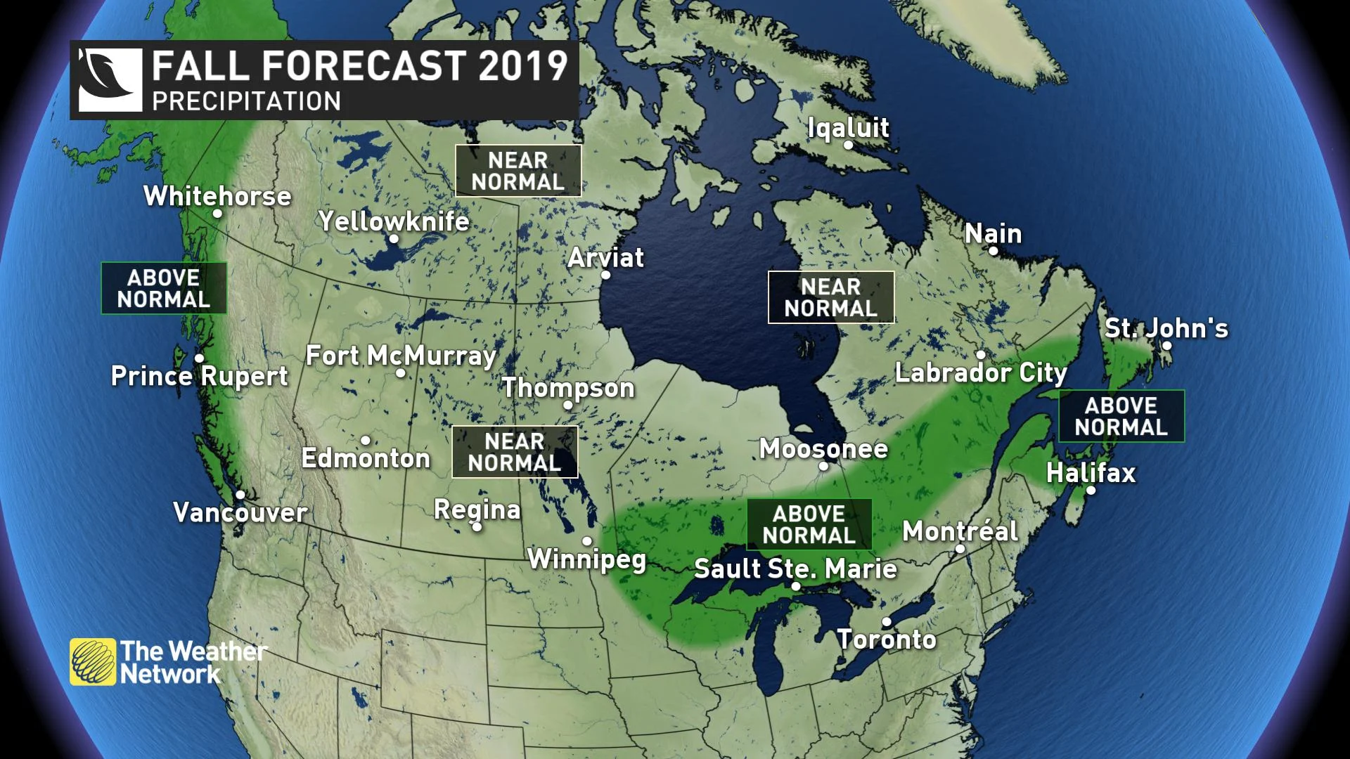
Most of Canada should see near-normal precipitation totals during the fall, but a few areas have the potential to end up wetter than normal. This includes coastal areas of British Columbia, where even a typical fall includes an abundance of rain. Much of Atlantic Canada should see above-average rainfall totals as well, due to a few systems that tap into tropical moisture and bring excessive rainfall totals.
Here’s a more detailed look at the conditions that we expect across Canada this fall:
BRITISH COLUMBIA
Warmer than normal temperatures are expected for the season as a whole, but that does not mean that B.C. will just coast through the fall season. Periods of colder than normal weather will also occur, but the final numbers should tip to the mild side of normal.
IN FOCUS: BRITISH COLUMBIA 'LOCKING INTO TUMULTUOUS PATTERNS'
Above normal precipitation totals are expected for coastal areas during a season that is notoriously wet. However, we do not expect more rainy days than normal. In fact, we expect that this fall will include extended stretches of dry weather. But we also expect periods of rainy weather that will bring excessive totals with the potential to get a month's worth of rain in roughly a week.
THE PRAIRIES
We will see extended periods of both mild weather and cold weather that offset each other during the fall season across Saskatchewan and Manitoba. However, we expect that temperatures will tip to the mild side of normal across Alberta despite some periods of chilly weather.
WATCH BELOW: RISK OF A FALSE START TO WINTER FOR THE PRAIRIES
It is important to keep in mind that "normal" temperatures drop by 2 to 3 degrees Celsius per week during the fall across the Prairies. Also, as all long-time residents of the Prairie provinces know, significant snow is a normal part of fall.
ONTARIO & QUEBEC
A typical fall is expected across the region with extended periods of both pleasant weather and periods of chilly weather that will come close to offsetting each other, except for near Hudson and James Bays.
IN DEPTH: AN ACTIVE STORM TRACK FOR ONTARIO
We will also see extended periods of dry weather during the fall with great opportunities to enjoy the fall foliage. A few moisture-laden systems should help to bring the final precipitation numbers to near normal or slightly above normal across the region.
FORECAST FOCUS: A TRANSITIONAL SEASON IN QUEBEC
ATLANTIC CANADA
Above normal temperatures are expected to dominate across southern areas, while typical fall temperatures expected elsewhere. While the fall will include stretches of dry weather, rainfall totals will tip to the wet side of normal across much of the region due to occasional storms that tap into tropical moisture and bring excessive rainfall.
IN DEPTH: BERMUDA HIGH BOLSTERS FALL TEMPERATURES IN ATLANTIC CANADA
NORTHERN CANADA
Milder than normal temperatures are expected across western regions with near-normal temperatures elsewhere. Most areas will see near-normal precipitation totals, but above-normal precipitation is expected for western parts of the Yukon.
WATCH BELOW: PACIFIC BLOB DRIVES WARM WEDGE INTO TERRITORIES
PRELIMINARY LOOK AHEAD TO WINTER
Be sure to savour the periods of pleasant weather that we will see during the fall because it does not look like Canada will get off easy with winter this year. Most of Canada east of the Rockies should see either a typical winter (which is still cold) or a colder than normal winter with a heightened potential for extended periods of severe cold.
SNEAK PEEK: A LOOK AT WHAT WINTER 2019 MAY HOLD FOR CANADA
MILD OR WILD FOR DECEMBER?
December is the biggest wild card for the winter. We do not expect the winter pattern to lock in until January, and we expect that a warm pattern over the eastern U.S. will fight back against winter and prevent consistent cold weather from the Great Lakes to the Maritimes during December.
The question we cannot answer just yet is whether this will result in a pattern that resembles last December -- which was rather mild across most of Canada -- or if there will be enough cold air in place across central Canada to fight back against the milder pattern, resulting in an active and stormy pattern from the Great Lakes to Atlantic Canada.
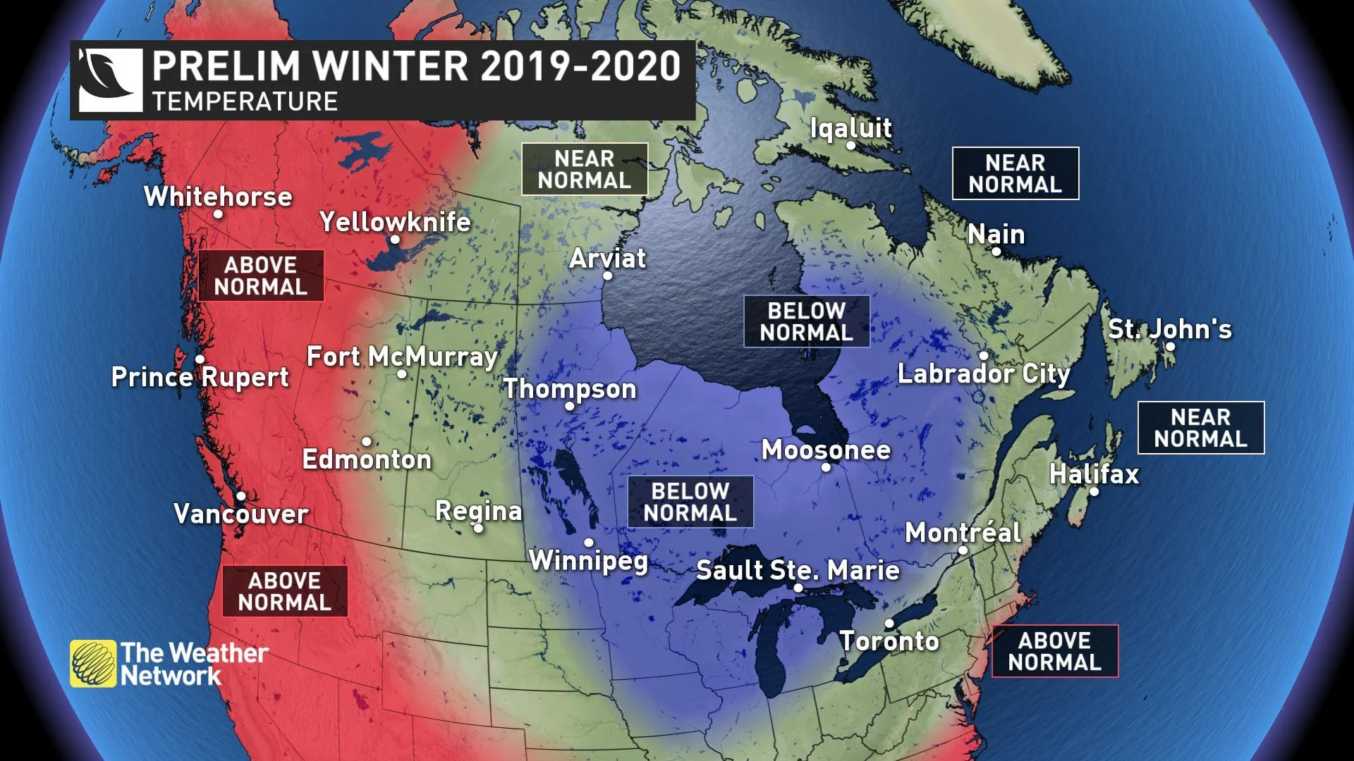
Regardless of how December plays out, we expect that the winter pattern shown on the above map will develop during January and then dominate through February and March.
While the drivers of the winter pattern appear to be more clear cut than they are with the fall pattern, a lot can change during the next couple of months, so please check back in November for the release of our final winter forecast which will also include more details on what we can expect during December, January and February, including a discussion on who should expect a snowy winter.