Prairies brace for intense winter storm, 60+ cm of snow possible

The first significant snow storm of the season is taking aim at the western Prairies, with dangerous travel set to last into the Monday morning commute.
EDITOR'S NOTE: This story has been updated. Click here for the updated version.
All eyes are on much of western Canada as the region quickly plunges from early fall right into the heart of winter. Winter storm watches and special weather statements have expanded, warning of dangerous travel and significant impact as this severe fall snow storm brews.
"This is high impact snow storm, potentially of historical significance, for southern Alberta and southwestern Saskatchewan this weekend and into early next week," says Weather Network meteorologist Dr. Doug Gillham.
Visit our Complete Guide to Fall 2019 for an in-depth look at the Fall Forecast, tips to plan for it and a sneak peek at the winter ahead
WEATHER HIGHLIGHTS:
Temperatures up to 15 degrees below seasonal this weekend
Majority of the snow will fall overnight Saturday and Sunday morning
Strong winds make for blizzard conditions in extreme southern parts of Alberta and Saskatchewan
Stay on top of ALERTS in your area
WATCH BELOW: SNOW TIMING
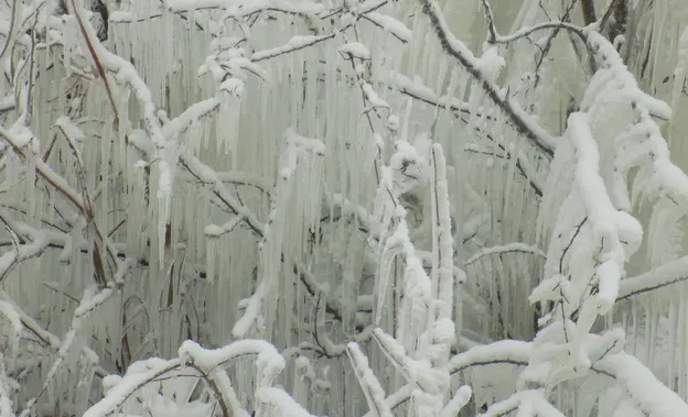
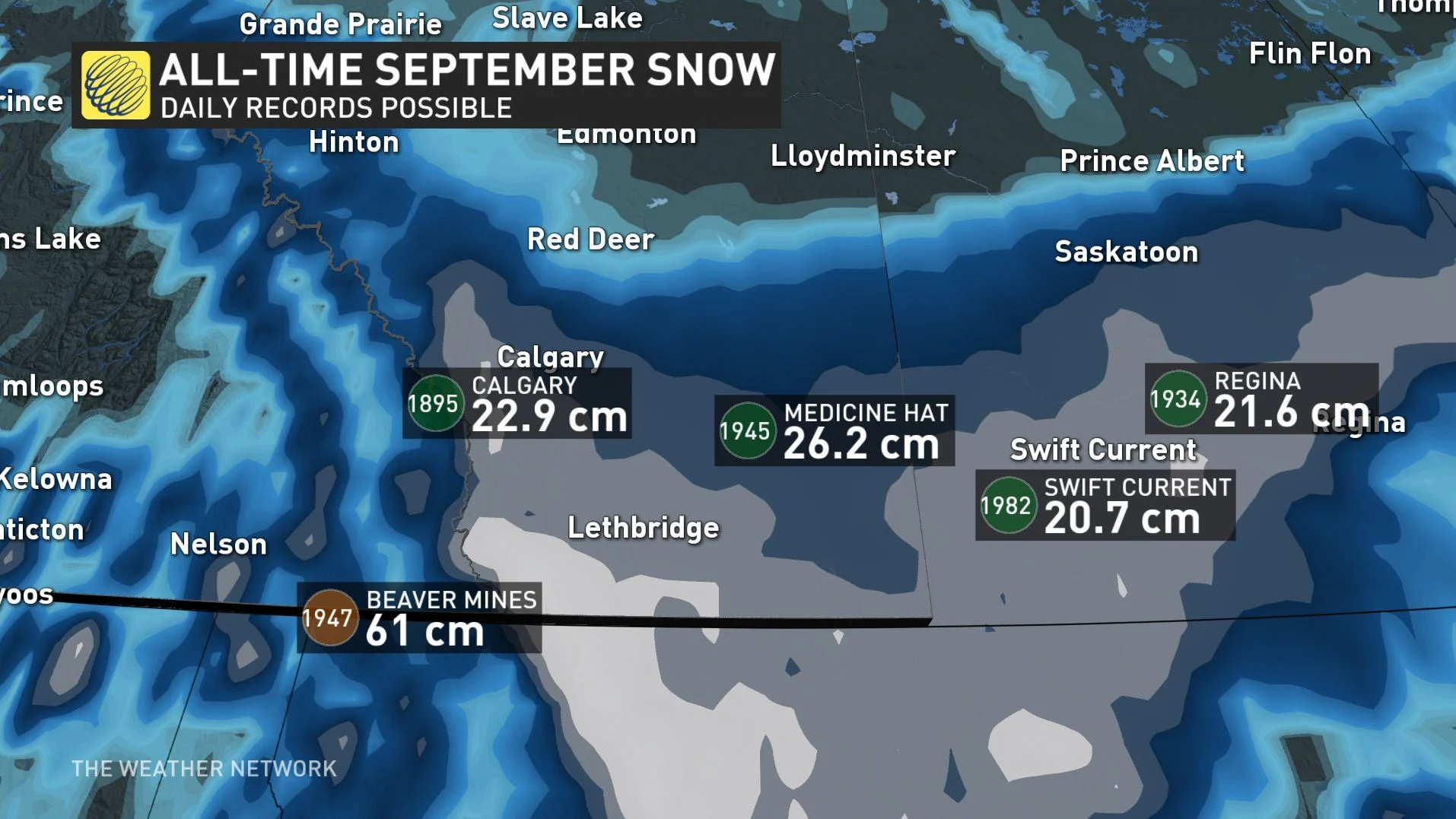
Falling temperatures, heavy snow and blizzard conditions. Ready or not, winter is coming and with extreme impacts possible over parts of the Prairies this weekend. Some areas could be looking at more than 60 centimentres of snow through Monday, which could end up being the most snow recorded this year, even through the winter months ahead.
"Expect severe impacts to travel, agriculture and recreation," warns Gillham. "There is a high risk for power outages and tree damage since the foliage is still on the trees."
WEATHER WARNINGS AND ALERTS: Stay prepared, here
WINTER STORM WATCHES IN EFFECT
Environment Canada has issued winter storm watches for parts of extreme southwestern Alberta, with special weather statements now covering the majority of the province ahead of this "long duration snowfall event."
There are parts of the high mountains of southwestern Alberta that could see 60 hours or more of snowfall, possibly racking up as much as a metre of snow over the duration.
While most places won't come near that level, amounts of 30-60+ cm aren't out of the question either.
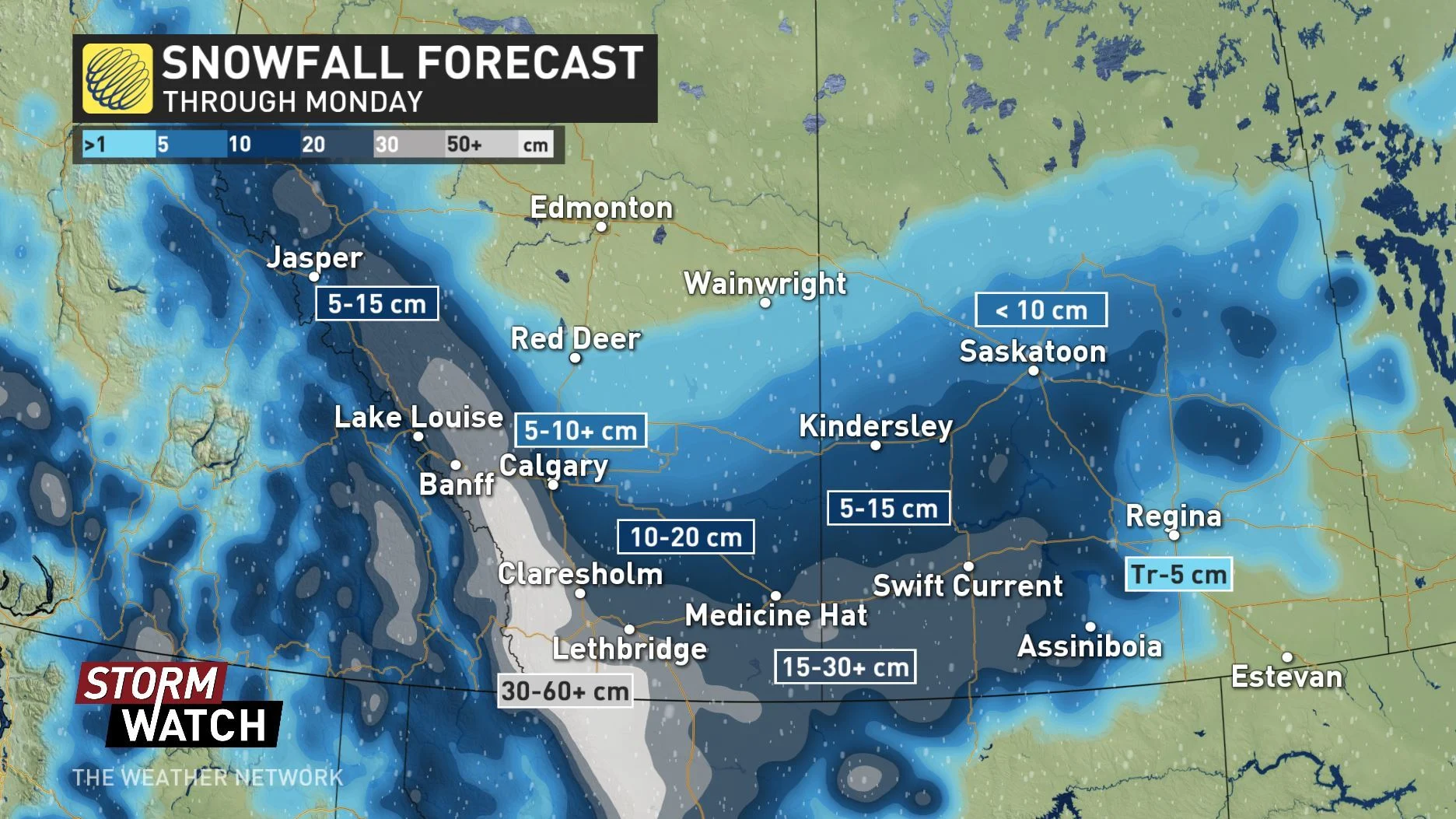
The greatest snowfall amounts are likeliest in the southwest and along extreme southern parts of Alberta and Saskatchewan, with major cities like Calgary likely picking up between 5-10 cm, although with potential for more significant accumulations. It's also a very tricky forecast for cities like Regina and Moose Jaw, Sask., as temperatures hover around 1-2°C.
"There is the potential for this area to substantially overachieve its snowfall amounts if temperatures end up near 0°C," Gillham says.
By Saturday afternoon, the real snowmaker will be a developing Colorado low -- so-named for its origins near the U.S. state of the same name -- as it spills its moisture north of the border and collides with the colder, arctic temperatures that have descended across the Prairies.
Travel will not be recommended not only in the mountains, but also the most southerly parts of the Prairies as strong winds, possibly gusting upwards of 50 km/h, will make for some dangerous blizzard conditions. Travel will quickly deteriorate, including along portions of Highway 1 and the QEII in southwestern Alberta through Sunday.
"This is not a 'difficult travel' type of situation, this is an extremely dangerous and near impossible travel scenario for the hardest hit areas," warns Gillham, adding that it's best to just stay home and off the roads if you can.
WATCH BELOW: TIMING OF STRONG WINDS
The snow is expected to continue through the overnight hours on Sunday for extreme southern Alberta and southwestern Saskatchewan before tapering off to flurries by early Monday.
Forecasters say there's still some uncertainty in the track of the storm and snow accumulations due to warm surface temperatures, so people in the region should stay alert as it develops.
"And keep in mind that this is a false start to winter, and not winter officially arriving across the west," says Gillham. "Although parts of Alberta, including Calgary, will remain below 0°C this weekend, we will see temperatures slowly recover next week with a warmer pattern setting up for the second week of October."
Stay with us here at The Weather Network for all your latest forecast updates.