Records are set to 'fall like dominoes' across Canada
The new season's temperamental nature is about to make itself felt across the country. Significant weather records -- nearly from coast to coast -- are in jeopardy for the end of September and the beginning of October.
With weather record traffic about to get heavy, we check out where the old records are clear to proceed, and where we may be stopping for an update.
Visit our Complete Guide to Fall 2019 for an in-depth look at the Fall Forecast, tips to plan for it and a sneak peek at the winter ahead
FROSTY START TO FALL IN THE WEST
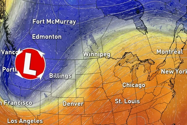
Through the weekend, overnight lows are expected to drop to the freezing mark in the Okanagan as an upper-level trough digs south with Arctic air. While the Okanagan will rebound during the day, the same can't be said further east.
Cranbrook's highs will struggle to reach the mid-single digits through the weekend, and there's the real risk for a new all-time September low to be set by Monday. The current record September low for Cranbrook is -6.9ºC, from an exceptionally frosty September 22, 2000.

Across the Rockies, Calgary and Lethbridge will undoubtedly be feeling the chill (more on that, below), but their chances for new records are iffy. With that said, Calgary's only had 14 days on record with highs below freezing, and we're looking at what will be possibly the coldest September high in the city since the 1970s.
Further north, Red Deer's record should be safely in the green, despite overnight lows dipping to near -5ºC.
But it's not just the temperatures that will feel wintry.

SMASHING ALL-TIME DAILY SNOW RECORDS?
Long-time residents of Alberta are no strangers to September snowfall, but the storms ahead for the last days of September stand to pack a wallop even by Alberta standards.
While the highest accumulations will stay where they belong for this time of year -- in the mountains -- low-elevation snow is also in the forecast, with 10 to 20 cm amounts widespread from the foothills to the Cypress Hills.

Even with up to 30 cm possible for the extreme southern foothills in just one day, most daily records should be safe here -- in the green across the board.
While Calgary looks to escape the most substantial accumulations, the city is notorious for its sneaky snow. Snowfall would have to top 22.9 cm there to break the city's one-day September record, which stretches back to September 19, 1895.
SOGGIEST SEPTEMBER?
All that heavy snow comes courtesy of abundant Pacific moisture -- moisture that's leading to some of the wettest Septembers on record for parts of B.C., and as far east as Winnipeg.

While Squamish, Vancouver, and Winnipeg are all looking at a finish in the top 10, it's West Van that's in the lead with nearly 200 mm so far. Even so, a record isn't a sure thing for this rainy region.

ALL-TIME OCTOBER HEAT?
On the flip side of the coin, the jet stream is ready to streak north over much of eastern Canada, with the focus for heat on southern Ontario and Quebec. That's where we'll see most of those old records stopped in their tracks as new values move in to take over.

Strong southwest flow may make the first few days of October feel uncomfortably like July in much of southern Ontario. Temperatures are expected to nudge above the 30ºC mark for many, and humidex values will soar even higher.
Since many all-time October records in the region are right around, or just above, the 30ºC mark, if the pattern pans out we'll see a lot of old records -- some that have been in place since the 1940s -- topple.
All in all, fall seems to be off to a tumultuous start across Canada, but will it stay that way? Check out our official Fall 2019 Forecast for the full story.


