
Cover up plants in parts of southern Ontario as May chill threatens frost
A good rule of thumb for planting frost-sensitive plants is to wait until after the May long weekend, and this year is no exception.
A rare, mid-May hard freeze, is coming to a city near you.
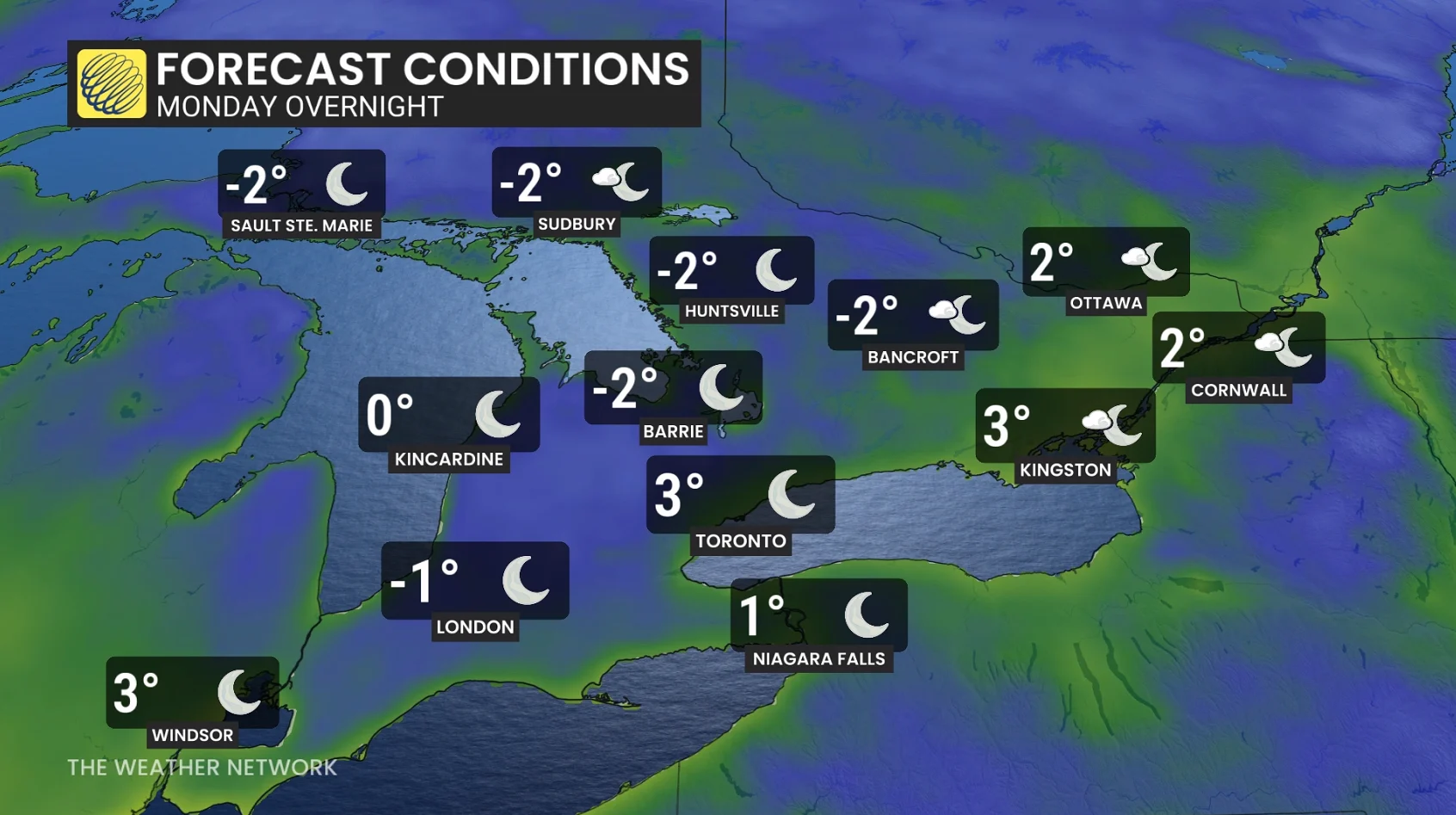
A widespread, potentially damaging frost is forecast across a large chunk of southern Ontario into Tuesday morning as we accelerate towards mid-May.
"Damage to plants, trees, and crops is possible," warns Environment and Climate Change Canada (ECCC) in the frost advisory. "Cover up plants, especially those in frost-prone areas."

SEE ALSO: The '3Cs' you need to know to protect your plants from frost
The pattern
A textbook recipe for a hard-freeze is imminent.
By Monday night, the centre of the high pressure with the lightest winds crosses southern Ontario, allowing ground temperatures to fall even lower.

RELATED: Stuck in a lull: Will pleasant spring weather ever reach Ontario?
Wind speeds are forecast to be approximately 5 km/h in the pre-dawn hours on Tuesday, with even calmer conditions locally likely.
Temperatures from London to Guelph could fall to as low as -3 C or -4 C during early Tuesday morning.
For May 12, that is an exceptional chill for this time of year. There has only been about 27 instances on record for Pearson International Airport of falling to freezing or below after this date.
But, how often has it happened after the year 2000?
Just three times:
May 13, 2020: -3C
May 19, 2002: -0.8 C
May 20, 2002: -0.1 C

There will be a local bubble of warmth around Lake Erie and Lake Ontario that will prevent a hard-freeze, but temperatures even in the Greater Toronto Area (GTA) will get dangerously close to the freezing mark (0 to -2 C for lows).
This is a very late frost for Pearson airport, with the typical last temperature at freezing is around April 27, but how does it stack up, historically?
If the temperature somehow falls to -4 C in London, it will be one of the coldest temperatures on record this late in spring.
-4.4C - May 12, 1907
-3.7C - May 13, 2020
-3.9C - May 21, 1895
May 2020 brought a severe May cold snap across the region, with temperatures falling close to -5 C at Pearson on May 9, and below -10 C in Timmins on May 5.
Latest freeze on record?
No, we’re still a couple weeks away from a record, late freeze for Toronto airport, with urban sprawl (urban heat island) and climate change signals making these all-time, late records essentially untouchable in the 21st century.

Toronto airport: May 28, 1949 (-0.6C)
Hamilton airport: May 24, 1963 (-1.1C)
London airport: June 11, 1972 (-0.6C)
Ottawa airport: June 9, 1980 (-0.1)
Thumbnail courtesy of Pixabay.
With files from Tyler Hamilton, a meteorogolist at The Weather Network.