How urban 'heat islands' can split and modify thunderstorms

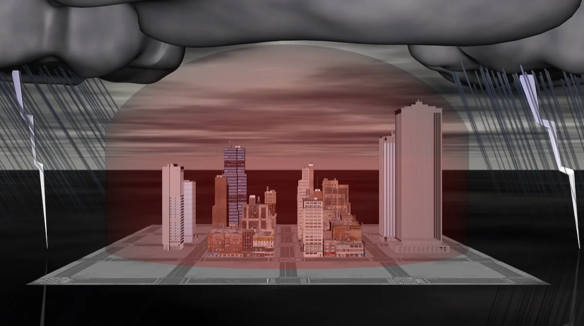
The structures of storms often change when they approach a major city, or urban heat island, diverting into two cells to avoid it and then consolidating once they pass.
Some thunderstorms will often take a detour around a major city and split into two separate cells before merging again, research shows.
A study published in 2011 put this to the test using radar imagery of the Indianapolis, Ind., metropolitan area for 10 years. The outcome: Storms tended to break off closer to the city and then amalgamate once they were downwind.
MUST READ: If humidity is not your friend, here are 5 things to try
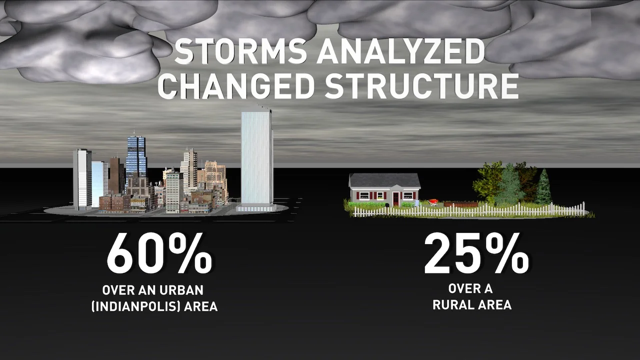
As well, more than 60 per cent of the storms reviewed in the decade-long examination modified their structure over the Indianapolis area –- significantly higher than 25 per cent of cells that changed over rural regions by contrast.
The research comes from Dev Niyogi, a professor in the department of geological sciences and the department of civil, architecture and environmental engineering at the University of Texas at Austin.
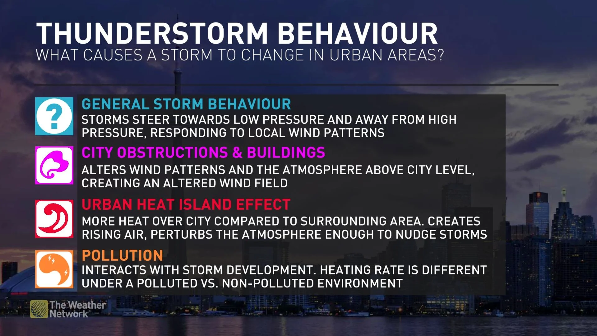
There are four contributing factors to what causes a storm to change shape as it nears a city: Friction from buildings, urban heat-island (UHI) effect, shape of the metropolitan developed and pollution, Niyogi told The Weather Network in a recent interview through email.
"Storms respond to convergence and divergence fields. Simply put, where winds find a local low pressure, they will steer in, and where winds find a local high pressure, [they] will steer away from," said Niyogi.
How storms adapt to urban heat islands
Cities have taller obstructions such as buildings, which have a different "roughness" to them that can alter wind patterns and the atmosphere above the city level, thereby creating an altered wind field, Niyogi said.
The second element is heating of the city, often referred to as an urban heat island. This translates to higher temperatures over the city compared to peri-urban and rural regions, he noted.
"This heating creates a lifting of the air mass, which can create rising thermals. These rising thermals can act as a means to perturb the atmosphere and approaching storms can be diverted away," said Niyogi.
The third component is the regional topography and terrain interacting with the city and its shape, thus providing storms coming from a certain direction with a "nudge to move away or towards the city," the professor stated.
Lastly, the pollution (aerosols) from the city can interact with the clouds, and that concentration within them "needs to be just right," Niyogi said. "Too little and it causes no rain, too much and it causes thunder..."
SEE ALSO: Powerful 'gigantic jet' seen over Oklahoma isn't what you think
He added, "cloud condensation nuclei number, size and type of aerosols, [and the] heating rate in the atmosphere is different under polluted versus a non-polluted environment, so it changes the convergence/divergence patterns."
WATCH: See how a storm changes near major cities
In terms of the frequency of the heat-island effect on thunderstorms, Niyogi said it depends on the city and where it is located. For cities that show “such a feedback,” it is about half the time. The impact is more pronounced during the day than night in the cases the researchers studied.
The study also found a sweet spot for a metropolitan size to have an influence on the storms: Approximately 25 kilometres. However, it can fluctuate, depending on the speed of the storm, he said.
"It is larger if it is a fast-moving storm; lesser size if [it is a] slow-moving storm with an intense heat island," said Niyogi.

(Getty Images)
Also of note is when the heat-island effect is most prevalent. Daytime is more prone to the influence than night, late afternoon and evening are more likely than in the early morning, and weekdays are more frequent than the weekends, he explained.
But it should be mentioned that heat islands don’t always have an influence on thunderstorms and they can trek through major cities as they are. Niyogi attributes these instances to the size of the city, as he mentioned earlier, with the storms moving away from and reemerging over it, as well as the terrain and pollution.
In addition, there is a seasonal feedback to the effect from urban heat islands and what occurs as a result of the influence.
“When the seasonally non-urban region changes, [for example]...in some regions it can be snow in the winter while it would be lush green in the summer, so there will be a change in the UHI value and also the type of storms being formed as a result,” said Niyogi.
WATCH: How a strong breeze off the Great Lakes intensifies storms
Follow Nathan Howes on Twitter.