
Warm stretch drawing to a close in Ontario, Quebec as all-time records add up

After breaking scores of daily and monthly records, the extended period of warm weather in Ontario and Quebec is coming to an end.
COMPARISON: Record-breaking blizzard paralyzes the Prairies with 40+ cm of snow
Residents across Ontario and Quebec have used any excuse to head outdoors as daytime highs soared well above seasonal since last week, making it feel more like the end of summer across the region.
In a month that typically delivers an abundance of cloud cover, cooler temperatures and even a potent snowstorm or two, this November has made a massive comeback in terms of being deemed as one of the worst weather months of the year.
The streak ends: Temperatures will drop in Ontario Wednesday morning.
Nothing lasts forever and this extended stretch of September-like weather is no exception. Temperatures will begin to cool down Wednesday morning as a cold front tracks across the region with a period of rain showers, strong winds and possible thunderstorms.
However, a westerly flow behind the front will limit the plummet and daytime highs will still hover around seasonal, even slightly above still.
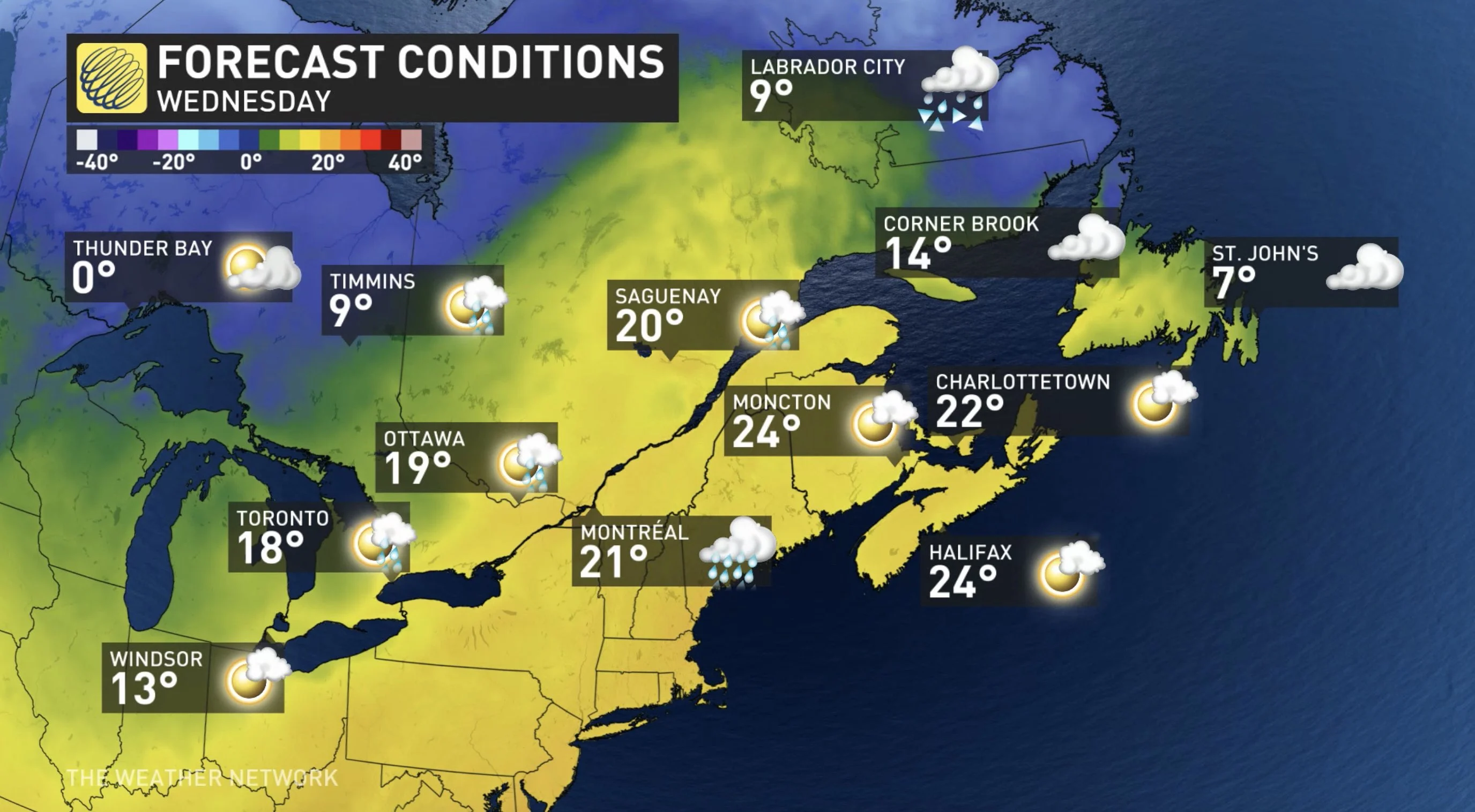
Meanwhile, in Quebec, the warmth will hang on a little longer, with a drop in temperatures late Wednesday afternoon.
THIS WARMTH IS TRULY UNIQUE
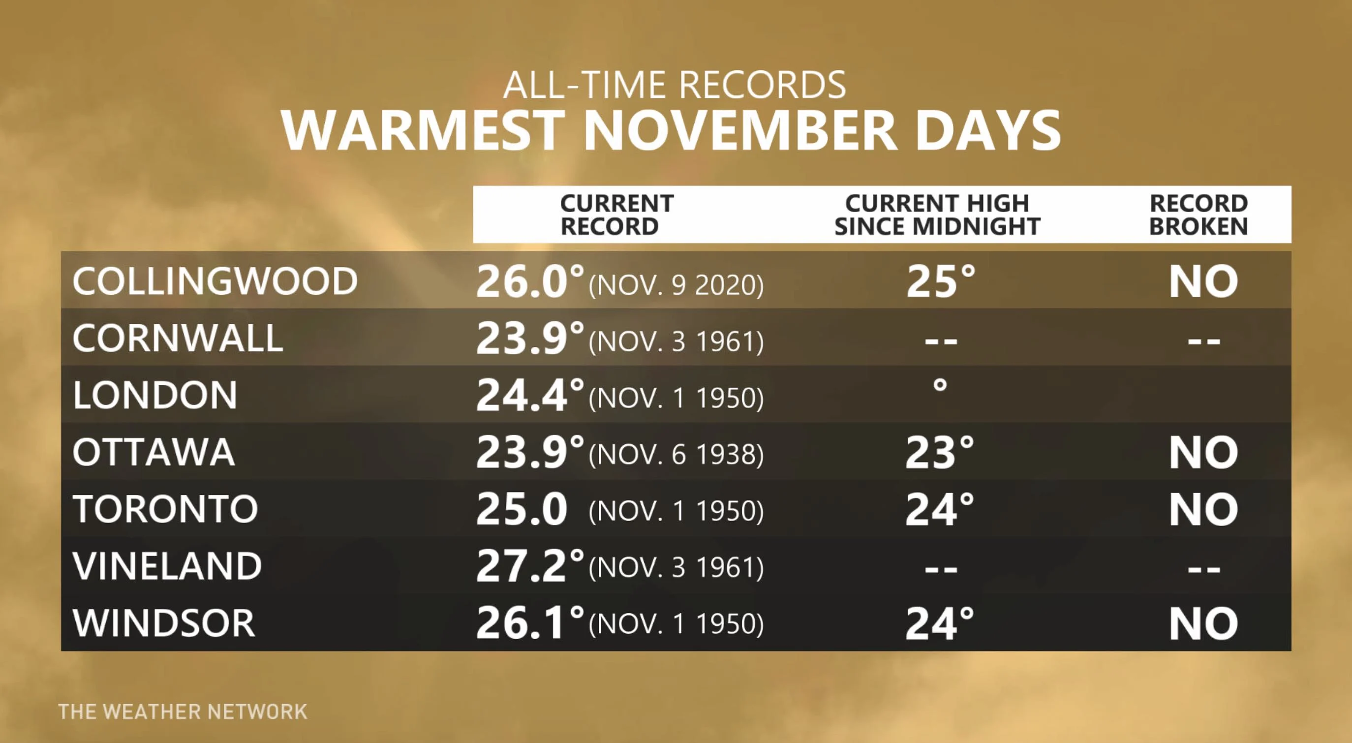
The daily record to beat at Toronto's Pearson airport is 17.8°C, set back on November 10, 1975 -- the day the Edmund Fitzgerald sank on Lake Superior.
"Record warmth in November is often associated with classic fall storms like we saw that day," says Weather Network meteorologist Dr. Doug Gillham. "That is what makes most of this past week unique. While we will be ending the streak with a storm, we had quite a streak of warmth without a storm pumping the warmth into our region."
ALL-TIME RECORDS SHATTERED
In this stretch of November warmth that just keeps on giving, several new daily temperature records have already been broken. Some of these records, especially in northern Ontario, smashed the previous one by several degrees.
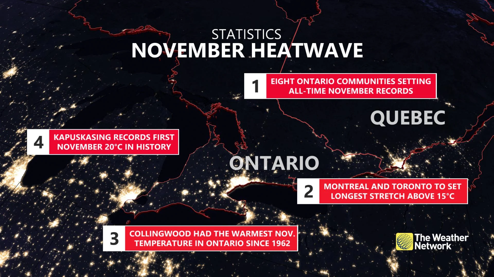
On the weekend, records reported on Sunday saw Toronto's Pearson airport hit 20.1°C, beating out the previous record of 19.4°C set in 1975. In the city of Ottawa, Sunday's new record of 21.5°C beat the last 21-degree day reported on November 8, back in 1938. Peterborough, Sudbury and Sault Ste. Marie also all broke records from at least 45 years years ago.
Records fell again Monday, with eight Ontario communities setting new all-time November records. Collingwood hit 26°C -- one of the warmest temperatures ever observed in November in Ontario. It nearly tied Windsor's record set on Nov. 1, 1950 (26.1°C) and was just shy of the province's hottest temperature, established in Vineland on Nov. 3, 1961 (27.2°C). Port Colborne was added to the list, hitting 20.9°C on Monday.
As well, Sarnia recorded a daytime high of 24°C, Wiarton reached 23.6°C and Petawawa saw a temperature of 22.7°C. In the north, Kapuskasing recorded its first 20-degree daytime high in November, reaching 21°C on Monday. Timmins hit 21.8°C, Sault Ste Marie reached 23°C and Moosonee warmed up to 19.6°C.
MUST SEE: From 20°C to 20+ cm of snow. Abrupt pattern change spans northern Ontario
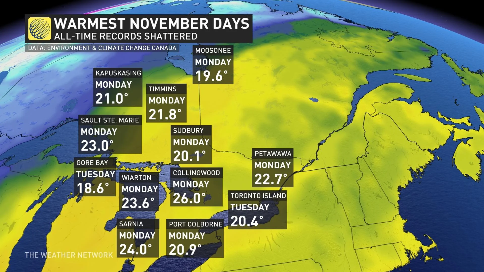
On Tuesday, the streak of record-setting temperatures hung on. Toronto Island went above 20°C for the first time in November history, reaching 20.4°. As well, Gore Bay hit 18.6°C.
In Quebec, numerous all-time November records have been broken, too. On Tuesday, Montreal reached 22.4°C, Gaspe hit 22.6°C, Bagotville hit 23.6°C and Maniwaki hit 23.1°C, among others.
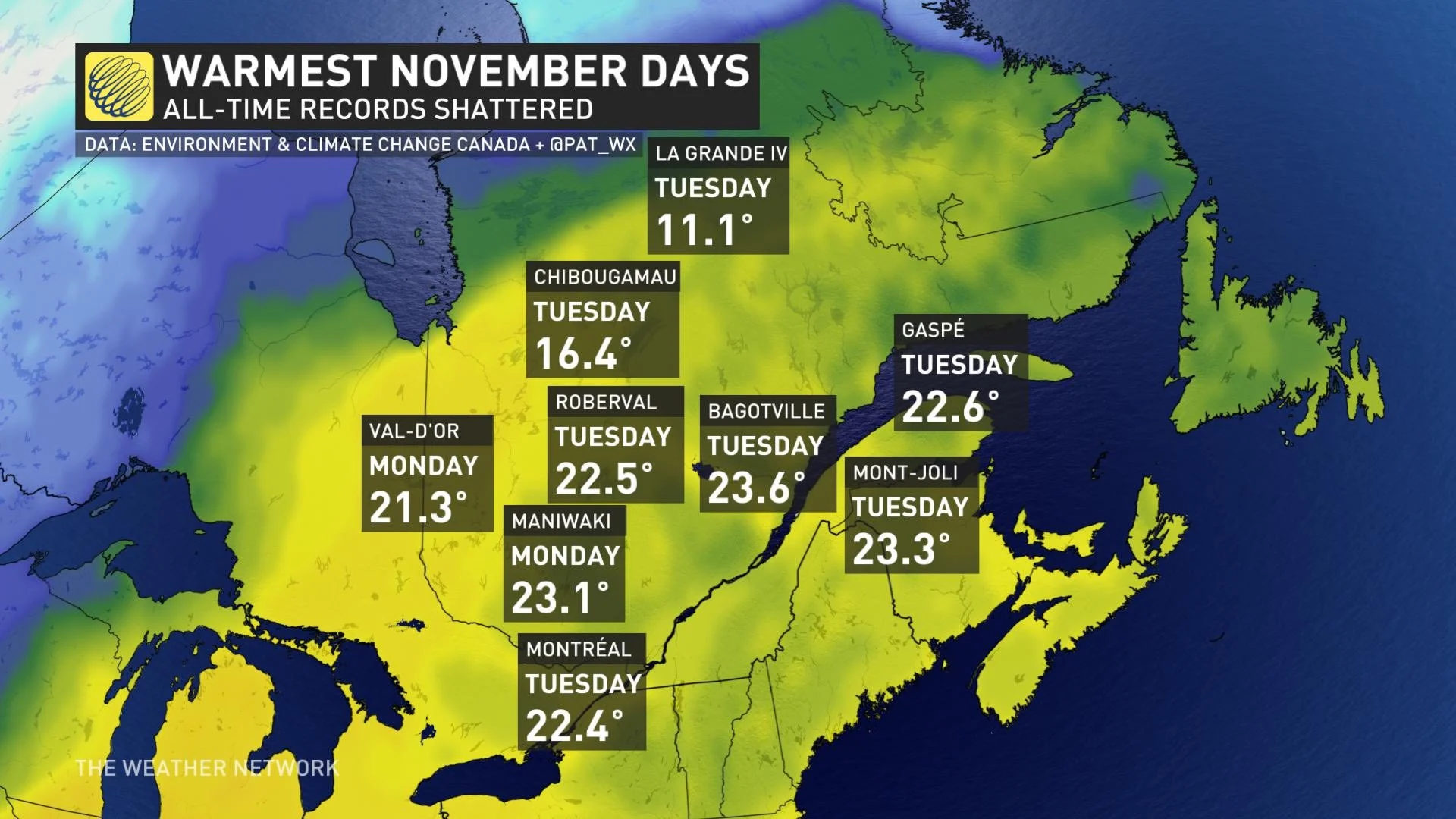
On Monday, Gatineau hit 20.8°C, surpassing the prior daily record of 17.2°C, set in 1945.
RECORD WARMTH REACHES ATLANTIC CANADA
It's not just Ontario and Quebec enjoying the spoils of the un-November-like warmth. The record-high temperatures have now spilled into Atlantic Canada, with several cities recording all-time records for November.
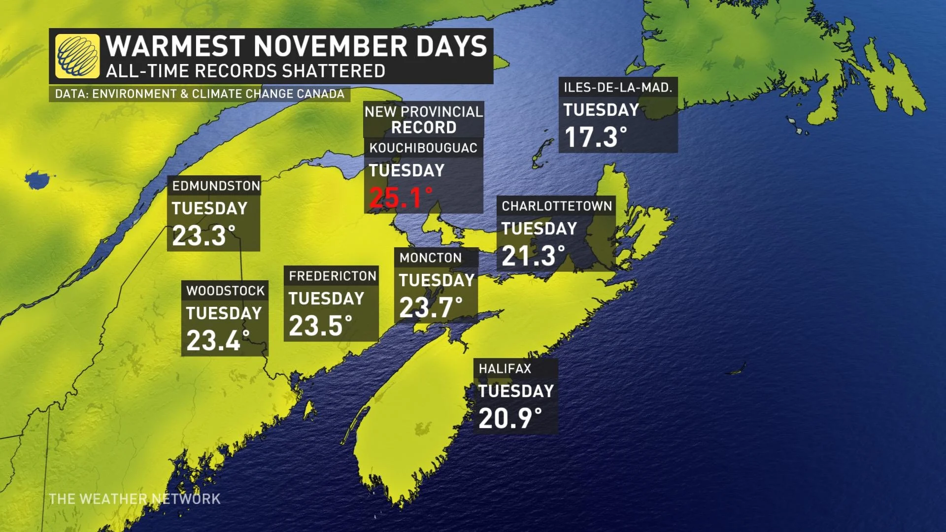
On Tuesday, Halifax hit 20.9°C, Charlottetown hit 21.3°C, Moncton hit 23.7°C, Fredericton hit 23.5°C, Woodstock hit 23.4°C, Edmundston hit 23.3°C, Kouchibouguac hit 25.1°C (new provincial record) and Îles-de-la-Madeleine hit 17.3°C.
RETURNING TO NEAR SEASONAL ON THE WEEKEND, POSSIBLE LAKE-EFFECT SNOW NEXT WEEK
The weekend will also see a return to near seasonal conditions, with eyes on some lake-effect snow flurries sneaking into the forecast early next week. Temperatures should trend back to slightly above seasonal for the second half of next week.
"A typical pattern is expected to dominate during the second half of November, but temperatures should tip to the mild side of normal. No sustained cold is in sight for this region," says Gillham.
Be sure to check back for the latest weather updates in your area.


