
Canada next in line for Hurricane Hilary’s rains after historic U.S. impacts

Hurricane Hilary will reach southern California as a tropical storm on Sunday, the region’s first in more than 80 years. Its moisture will move into Canada next week
A catastrophic flash flood threat will cover much of the southwestern United States through Tuesday as Hurricane Hilary tracks along a path not seen in more than 80 years.
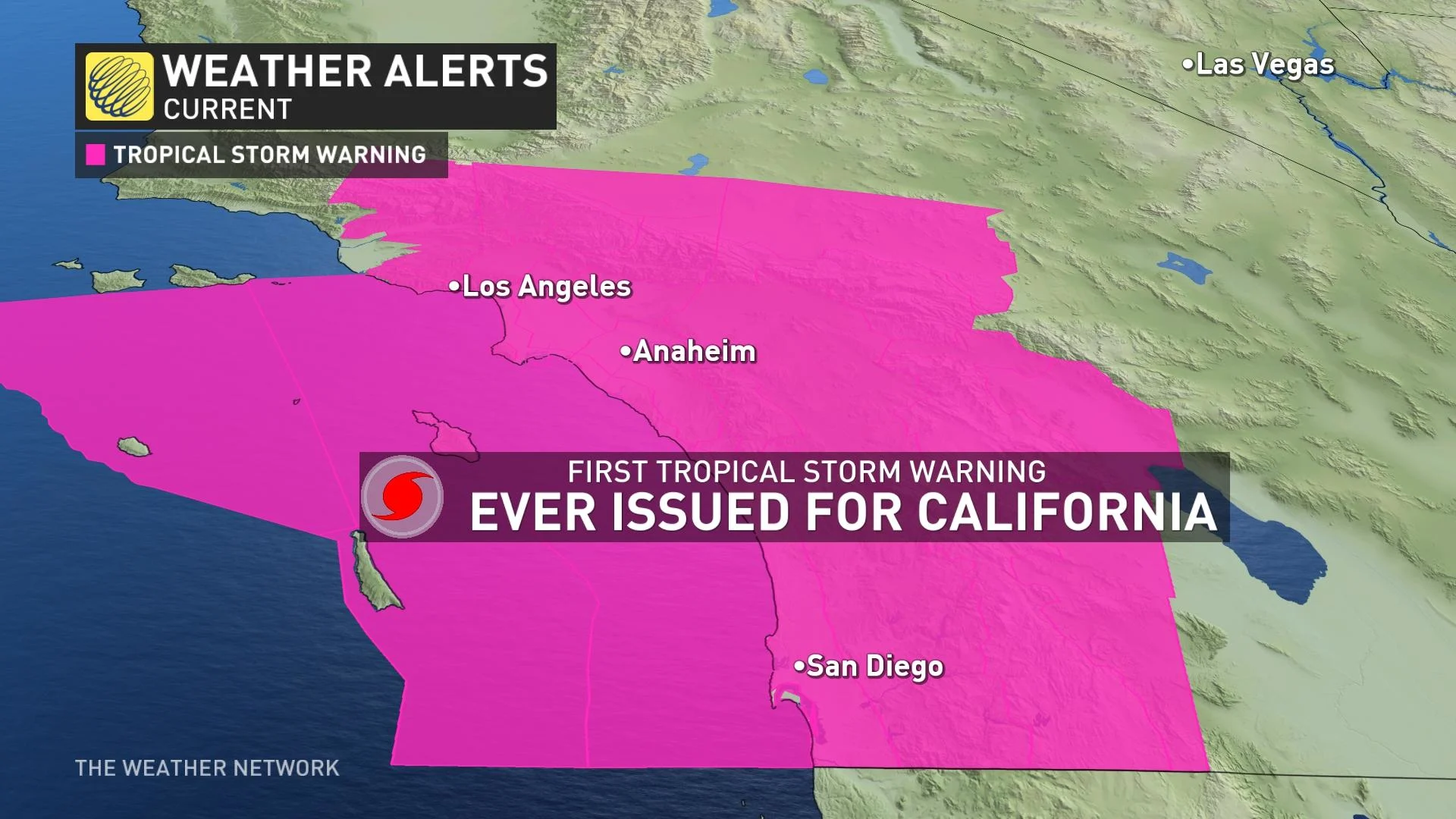
The U.S. National Hurricane Center (NHC) issued its first-ever tropical storm warnings for southern California on Saturday, covering tens of millions of people throughout the Los Angeles, San Diego, and San Bernardino metropolitan areas.
RELATED: Catastrophic flood threat in California as Hurricane Hilary nears
Folks throughout the deserts and mountains of southern California and southern Nevada will likely experience drenching rains on the order of 100+ mm through early next week.
The amount of rain on the way will likely break all-time records for many areas, unleashing widespread and destructive flash flooding and landslides throughout the region’s vulnerable terrain.
Gusty winds will compound a dangerous situation, potentially leading to tree damage and power outages in the region's densely populated metro areas.
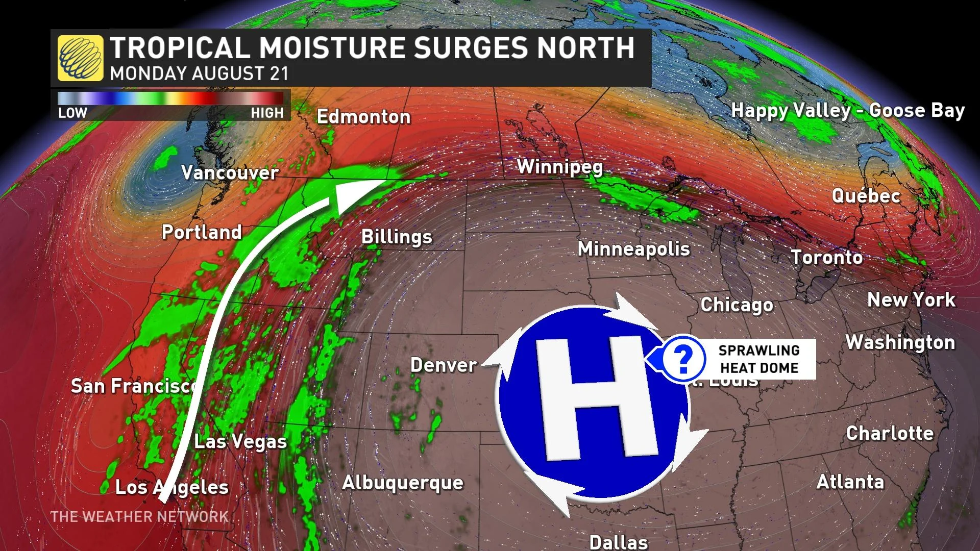
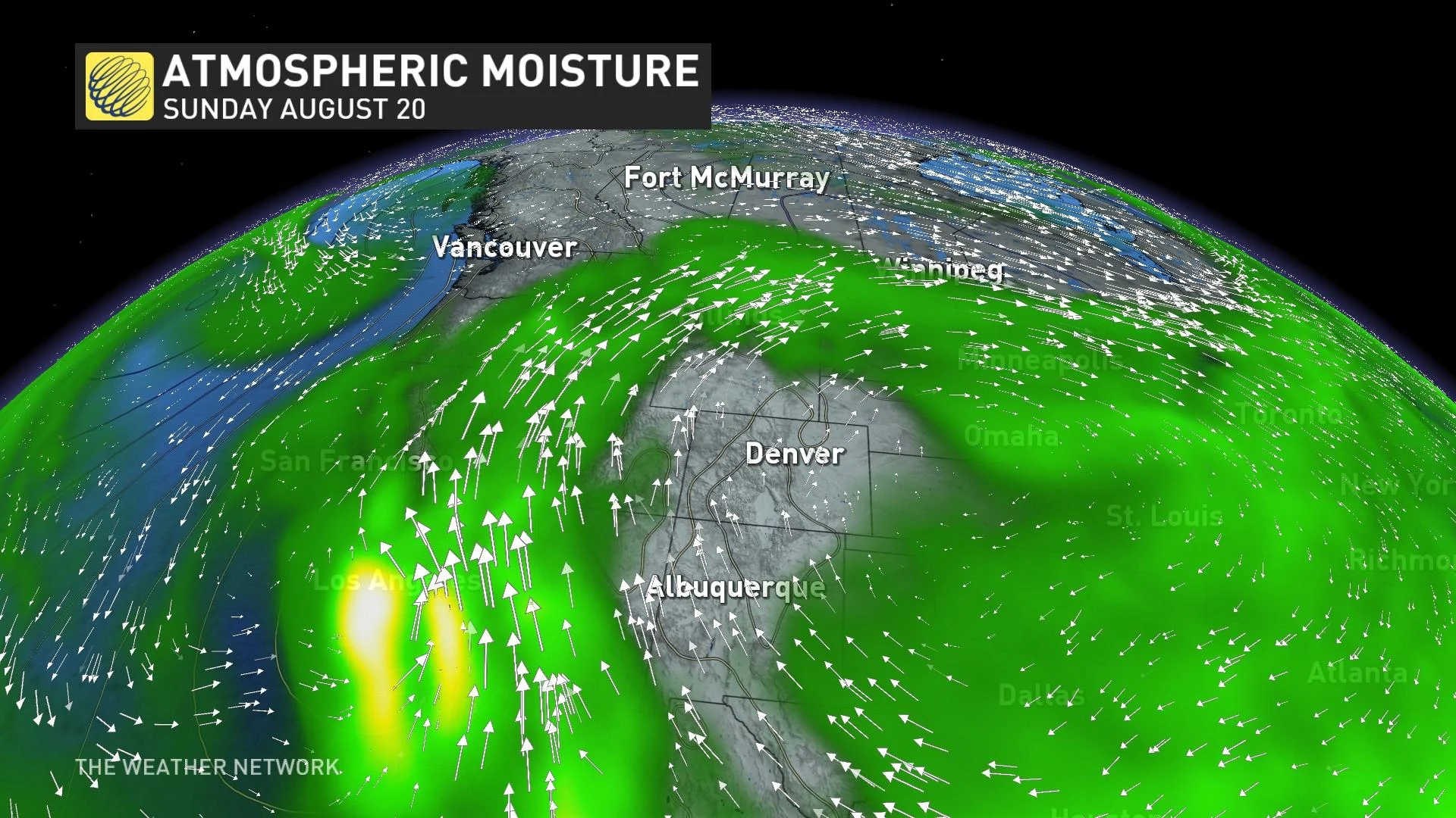
Hilary’s effects won’t stop with the American Southwest. The system’s moisture will continue flowing north over a large ridge parked over the central United States, bringing cloudy skies and rain deep into the heart of Canada heading into next week.
Hilary beginning its final approach into Mexico, U.S.
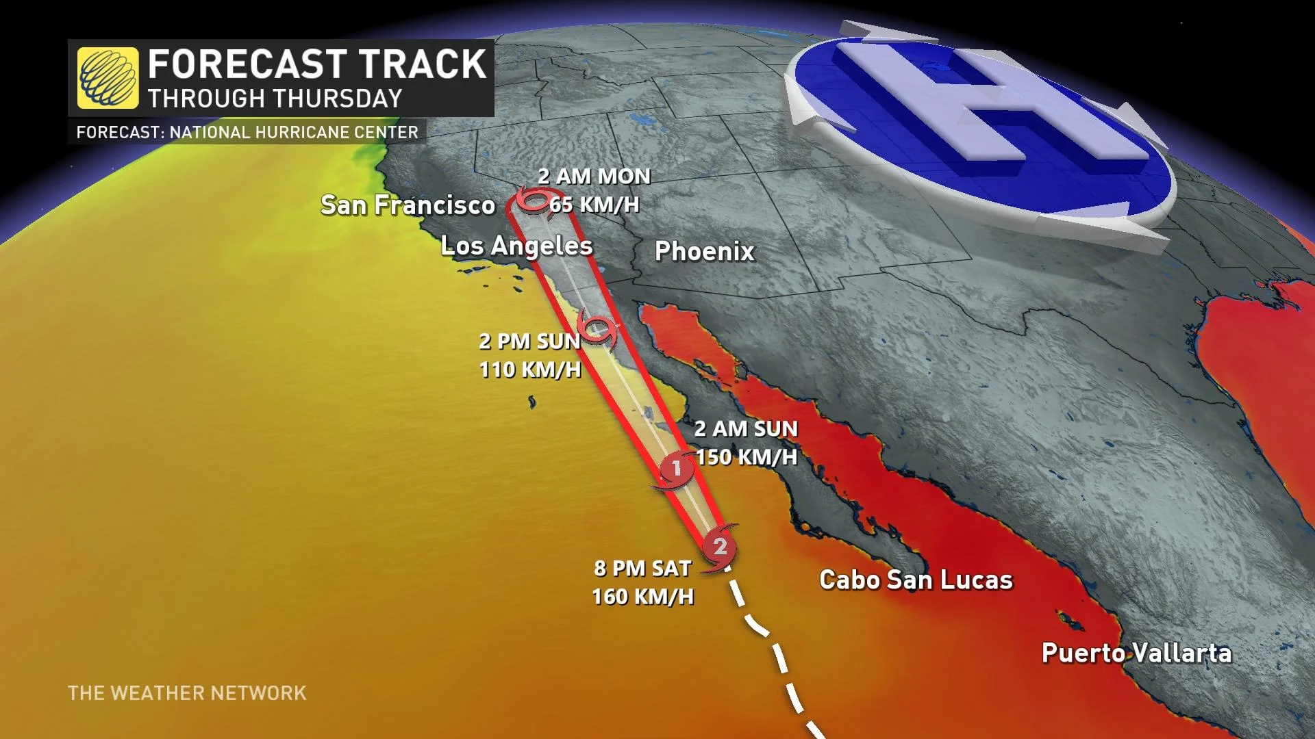
Hurricane Hilary peaked on Friday as a formidable Category 4 storm with maximum sustained winds of 225 km/h. It’s since begun its long-anticipated weakening trend, as unfavourable atmospheric conditions and cooler ocean waters rob the storm of the energy it needs to thrive.
MUST SEE: The best way to prepare for a hurricane is well ahead of a potential disaster
Despite the storm’s winds starting to tick down, Hilary’s looming impacts on the U.S. Southwest are essentially baked in at this point. The storm’s prolific tropical moisture will continue surging inland even as its structure begins to degrade.
Forecasters with the NHC expect Hilary to make landfall on Mexico’s Baja Peninsula on Sunday afternoon, eventually crossing the international border into California near San Diego by Sunday evening. If the predictions pan out, this would be the first tropical storm to reach California soil since 1939.
Catastrophic flooding likely for southern parts of California, Nevada
The storm’s influence arrived Saturday as rounds of heavy rain began washing over the deserts of the American Southwest. Flash flood warnings were already in effect throughout extreme southeastern California as a result of heavy rain influenced by the storm’s outer fringes, with the bulk of the moisture still to come on Sunday and Monday.
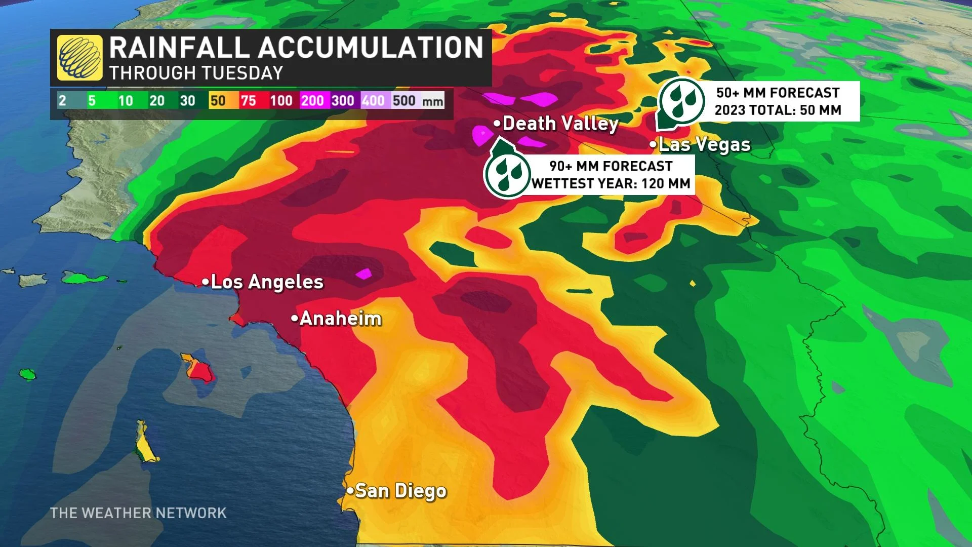
Death Valley, California, only measures about 55 mm of rain in an average year, with records there stretching all the way back to June 1911.
The U.S. National Weather Service (NWS) expects Death Valley to receive about 90 mm of rain through Tuesday morning, which would resoundingly shatter all-time records for the wettest day, wettest week, and wettest month ever measured there. This much rain would easily secure 2023 as Death Valley’s wettest year on record.
RELATED: Beware: Flood insurance isn't guaranteed, and the type you have can vary
It’s a similar story in nearby Las Vegas, Nevada, the world-renowned vacation destination that hosts millions of visitors every year. The desert climate in Las Vegas only provides the city about 100 mm of rain every year. The latest NWS forecast calls for about 50 mm of rain over the next three days.
If the flash flooding threat weren’t enough of a hazard, Las Vegas will see a risk for tornadoes in any thunderstorms that develop over the region on Sunday as Hilary pushes inland. Fast-moving tornadoes are a common hazard as tropical systems make landfall.
Hilary sends Canada a dose of tropical moisture this week
The remnants of Hilary will pick up speed and continue pushing north after its deluge in the western U.S.
A formidable heat dome setting up over the central United States will send daytime high temperatures well into the 40s for a vast swath of the country through the upcoming week.
The outer edge of a heat dome this intense acts like a guardrail that forces all systems to scoot around the ridge.
This will force Hilary’s remnant moisture to flow into Western Canada through next week, bringing widespread clouds and occasional bouts of rain to the region. Some of the rain in Alberta could be heavy at times in the Rockies and the foothills.
We could see some of that moisture spill toward Ontario and Quebec later in the week, bringing the potential for clouds and rain heading toward next weekend.
Header image courtesy of NOAA.