Catastrophic flood threat in California as Hurricane Hilary nears

Tropical storm warnings are in effect for Los Angeles and San Diego as Hurricane Hilary aims for the southwestern United States
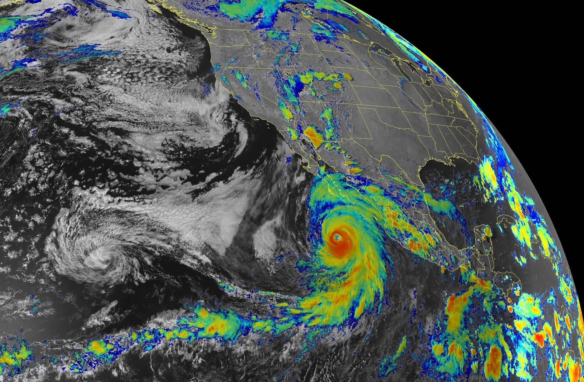
For the first time in modern history, a tropical storm warning is in effect for much of Southern California as Hurricane Hilary threatens the region late this weekend into early next week.
While the major hurricane’s winds will lose their punch on approach to Southern California, Hilary will still arrive in the region as a formidable force with gusty winds and drenching rains that could unleash catastrophic flooding throughout much of the desert-covered American Southwest.

DON’T MISS: Saharan dust can make or break a monstrous Atlantic hurricane
Tropical cyclones almost unheard of along the U.S. West Coast
The U.S. National Hurricane Center (NHC) issued a tropical storm warning for much of Southern California ahead of the system’s arrival on Sunday and Monday. This is the first tropical cyclone alert ever issued for the U.S. West Coast.
Only folks who are in their late 80s or older would remember the last time an event like this unfolded.
The last time an organized tropical system approached Southern California at strength was an unnamed tropical storm that made landfall north of Los Angeles in September 1939.
Before that, a hurricane in 1858 grazed San Diego with destructive winds—to put that into perspective, that hurricane occurred three years before the American Civil War and nine years before Canadian confederation.
Since then, only 1997’s Hurricane Nora briefly survived as a decaying tropical depression as it moved into the U.S. near the state line between California and Arizona.
Tropical systems are exceptionally rare in this region because sea surface temperatures off the coast of California are far too cold for a storm to survive. It’s more common for the remnants of storms to bring heavy rain to the region.
Hilary could bring ‘catastrophic’ flash flooding
Hilary started the day Friday as a powerful Category 4 hurricane with maximum sustained winds around 235 km/h. The system remained near peak strength for much of the day before beginning a slow but steady weakening trend that’ll continue over the next several days.

Despite the storm’s maximum winds weakening, the system will remain a powerful force as it makes landfall on Mexico’s Baja Peninsula and continues pushing inland toward Southern California.
Forecasters expect Hilary to remain a tropical storm as it crosses the international border and passes east of San Diego and Los Angeles, potentially packing winds as high as 90 km/h as it sweeps through the region late Sunday into Monday.
MUST SEE: El Niño is here for the summer—but how strong will it grow?
Even as the storm loses strength, it’ll bring a tremendous surge of tropical moisture into an area that only receives a tiny amount of rain every year.

The NHC warned of the potential for “dangerous and locally catastrophic” flash flooding throughout portions of Southern California, southern Nevada, and western Arizona.
The flooding threat includes the major urban areas of Los Angeles, San Diego, Riverside, and San Bernardino in California; Las Vegas, Nevada; and Yuma, Arizona.
All-time rainfall records at risk of falling
Widespread rainfall totals of 100+ mm are expected throughout the region, with some desert and mountainous portions of California and Nevada expecting 150-250+ mm of rain through early next week. This will lead to significant and widespread flash flooding and landslides throughout the region, even inundating areas that wouldn’t typically flood.
Death Valley, Calif., usually receives about 55 mm of rain in an entire year. The most rain they’ve ever recorded in a single year was 120 mm back in 2005.
The current U.S. National Weather Service (NWS) forecast for Death Valley calls for about 110 mm of rain through Tuesday —- a staggering rainfall prediction that would almost match Death Valley’s wettest year on record in just three days.
The agency also noted that the deluge in Nevada could rival the state’s 24-hour rainfall record of 197.6 mm, set at a station in the mountains west of Las Vegas back in 2004.
Header image courtesy of NOAA/NASA