
Weather bomb sets sights on Atlantic Canada with impactful winds, rains
A powerful 'weather bomb' is targeting the East Coast this weekend, threatening to bring damaging wind gusts and localized flooding to many areas as it swiftly moves through
Batten down the hatches, Atlantic Canada. It's going to be quite the bumpy ride this weekend with the arrival of a storm that is deemed to be a weather bomb –– a low that experiences a pressure drop of at least 24 millibars in 24 hours.
Similar storms in the past have caused power outages from the winds and hazardous driving conditions from water pooling on roadways and localized flooding, especially in poor drainage areas.

Ensure any loose decorations or furniture outdoors are secured or brought inside before the gusty winds arrive. Keep your devices charged and flashlights handy in case the lights go out.
If you do not need to be on the road, it's recommended you avoid travel as conditions will be rough with the potential for 100 mm of rain and wind gusts in excess of 100 km/h at times during the storm.
DON'T MISS: ‘Weather bombs’ are explosive storms that create ferocious conditions
Strengthening storm could bring hefty impacts
Our weekend weather bomb is currently revving up off the U.S. East Coast. This low-pressure system will tap into upper-level winds and quickly strengthen over the next 24 hours, rapidly deepening its minimum central pressure.
This sharp intensification into a weather bomb is a process known as bombogenesis, which occurs when a storm’s pressure drops at least 24 millibars in 24 hours. Such a swift drop in air pressure will allow the storm to produce wicked winds and heavy precipitation rates as it approaches the region this weekend.
The storm will tap into a vast reserve of moisture streaming in from the south as it arrives this weekend. At the same time, cold air funnelling in from the west will filter over interior sections of the Maritimes.
Combined, these factors will lead to a prolonged period of widespread gusty winds throughout Atlantic Canada, as well as bountiful heavy rainfall and the potential for accumulating snows across the west.
MUST SEE: Brace for chill: Arctic air oozing into Canada for next week
WATCH: Heavy rain may bring localized flooding to Halifax
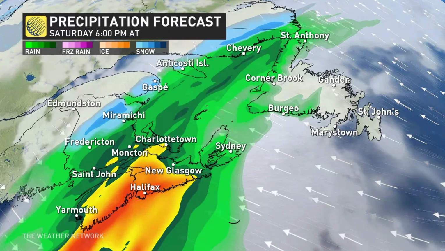
The Maritimes will see the worst on Saturday
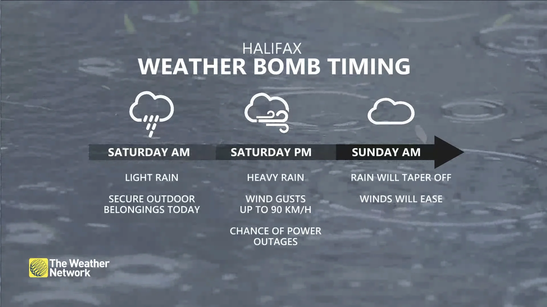
Heavy rain and gusty winds will arrive in the Maritimes on Saturday afternoon, with conditions rapidly deteriorating in the evening. Rainfall warnings and wind warnings are in place across much of Nova Scotia and Prince Edward Island ahead of the storm’s arrival.
Due to the high winds and heavy rain heading for Halifax, this year's Holiday Parade of Lights has been postponed until Saturday, November 25, according to the event’s official webpage.
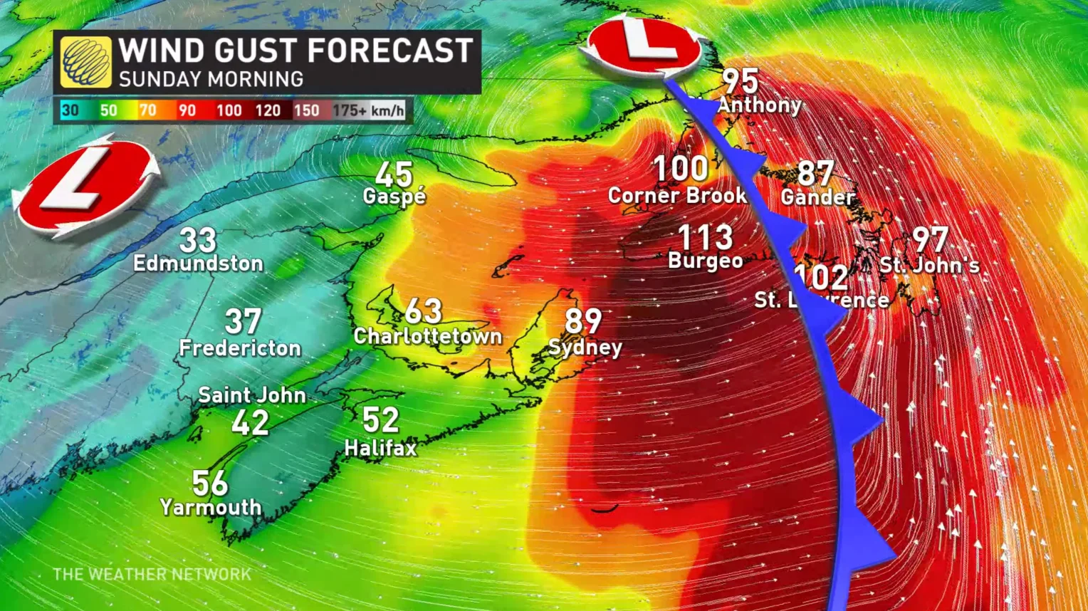
This storm’s greatest threat will be gusty winds that could exceed 100 km/h at times near the coast.
During the evening, the wind speeds will pick up. The eastern Maritimes will see the strongest wind gusts of 80-100 km/h, with Halifax, N.S., caught right in the middle with 70-90 km/h gusts. Wind gusts will ease overnight with most areas in the Maritimes.
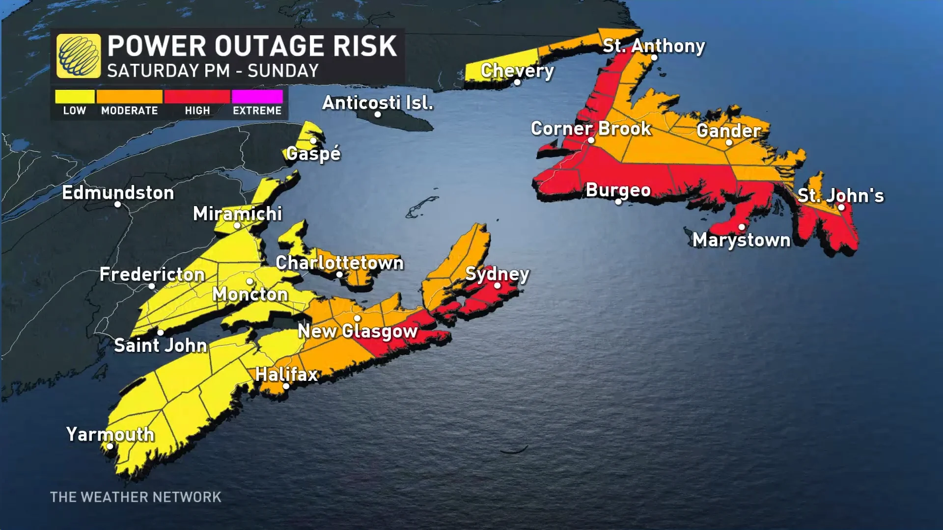
Gusty winds blowing over rain-soaked soils could bring down trees and power lines, leading to a risk for power outages in the region.

PLAN AHEAD: Staying safe during a power outage
High winds are likely across much of coastal Nova Scotia and eastern Prince Edward Island during the storm. We’re likely to see rough surf and a chance for coastal flooding during onshore winds.
Forecasters see the highest risk for power outages along the coast from Guysborough County up toward Sydney and the eastern half of Cape Breton Island. A moderate chance for power outages exists around Halifax, Truro, and Charlottetown.
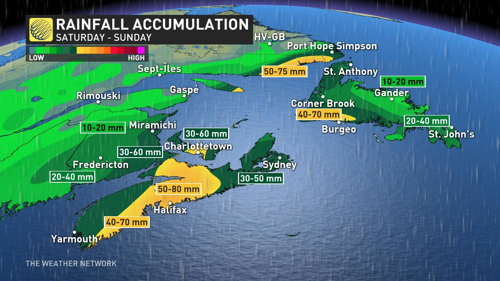
A slug of heavy rain will follow the storm as it tracks across the Maritimes on Saturday. Rainfall rates could grow heavy enough that localized flooding is possible, especially across southern and central Nova Scotia.
Widespread rainfall totals of 50-80 mm are expected across Nova Scotia, with the most rain likely centred around Halifax.
While conditions will prove the worst at the coast, we’ll see blustery conditions and heavy rains extend farther west into New Brunswick and the western end of Prince Edward Island. These areas could see 30-60 mm of rain in the gauges by Sunday.
Colder conditions farther west will allow rain to change over to snow across the northern half of New Brunswick on Saturday evening. We’ll see snowfall totals of 5-10 cm across far northern reaches of the province by Sunday morning, with greater totals likely on the Gaspe Peninsula.
Conditions across the Maritimes will improve in a hurry as we head into early Sunday morning as the storm pulls north toward Newfoundland and Labrador.
Newfoundland and Labrador catch the storm’s worst on Sunday
The leading edge of our potent storm will push into Newfoundland late Saturday afternoon with rain and gusty winds picking up from south to north.
Conditions will rapidly deteriorate across Newfoundland through the overnight hours Saturday into early Sunday as the heart of the storm approaches the island.
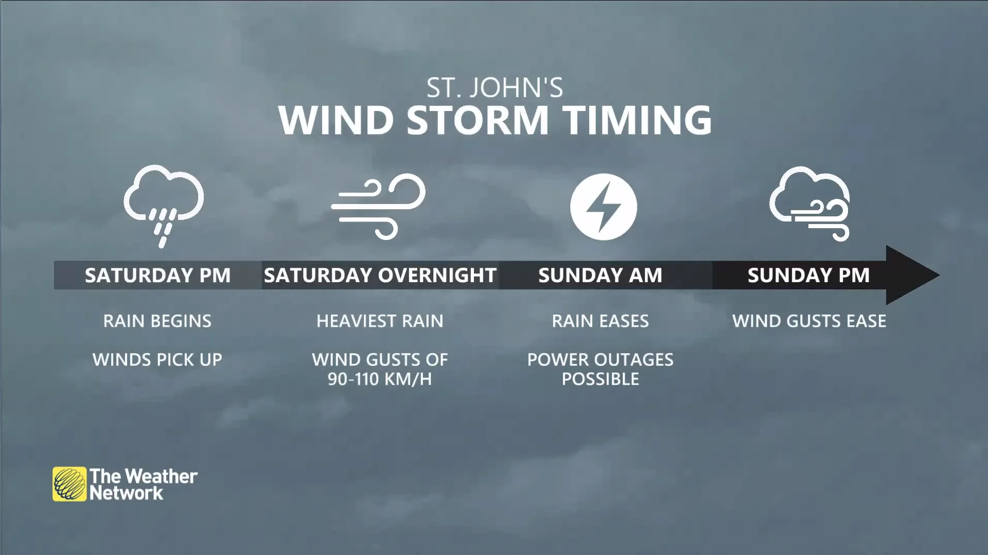
Heavy rainfall and widespread wind gusts of 90-110 km/h are likely overnight Saturday into Sunday, especially along coastal sections and immediately inland. Power outages are possible, especially on south-facing coasts around Burgeo and Marystown.
SEE ALSO: When the lights go out, stay lit with these emergency candles
Thankfully, this storm doesn’t plan to overstay its welcome. St. John's will receive 20-40 mm of rain by Sunday afternoon, with winds slowly easing through the afternoon and evening.
While southerly flow will keep Newfoundland above the freezing mark for the duration of the storm, plenty of cold air locked in place over Labrador will make this a solid snowfall event for the region.
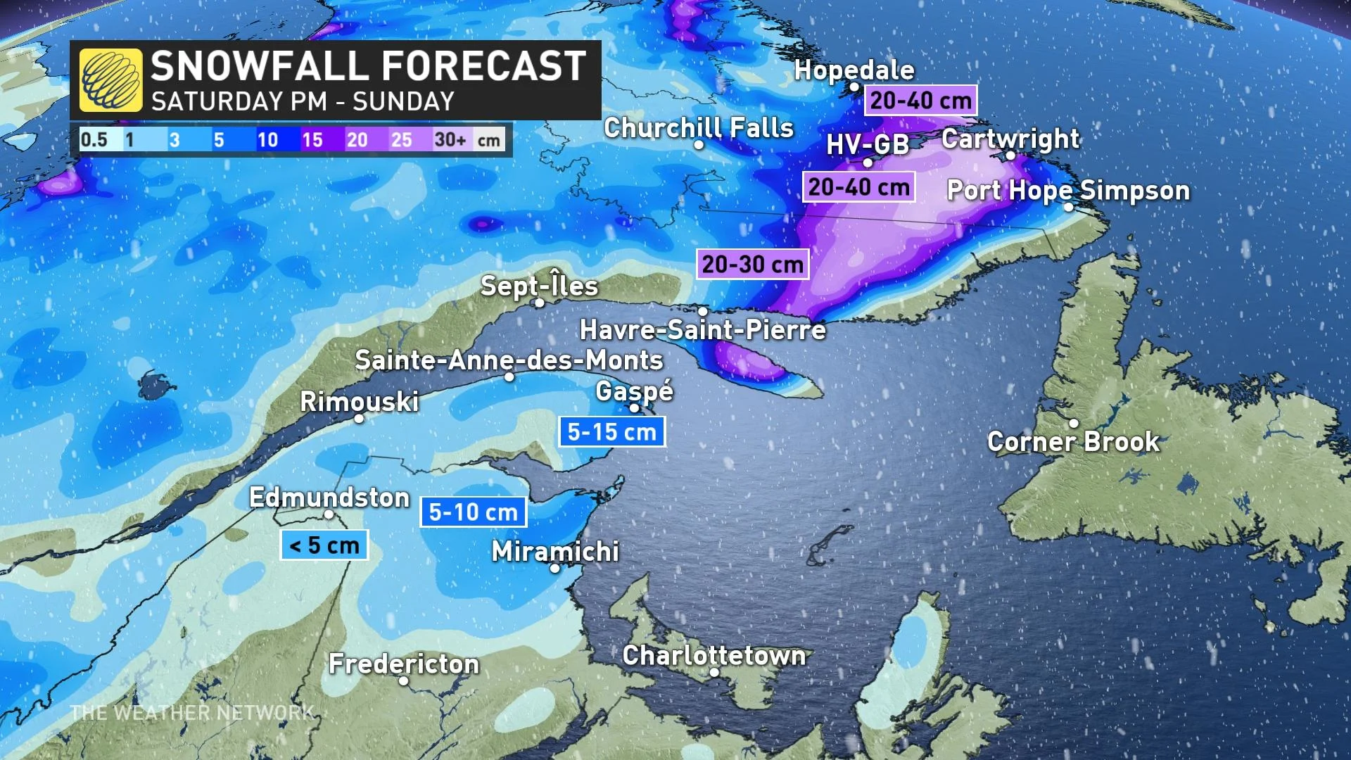
Forecasters expect a large swath of 20-30 cm of snow throughout eastern Quebec and Labrador. Happy Valley-Goose Bay is expecting a solid blanket on the ground by the end of Sunday, with 20-40 cm likely.
Looking ahead, blustery and much colder weather will spread over the Atlantic provinces to start the week. Forecasters are watching the potential for another system to approach the region for the second half of next week. Below-seasonal temperatures are expected to stick around for the final week of November.
Stay tuned to The Weather Network for the latest forecast updates in Atlantic Canada.