Warnings expand as atmospheric river streams heavy rain into the East Coast

Heavy persistent rain threatens as much as 100 mm over parts of the East Coast this week.
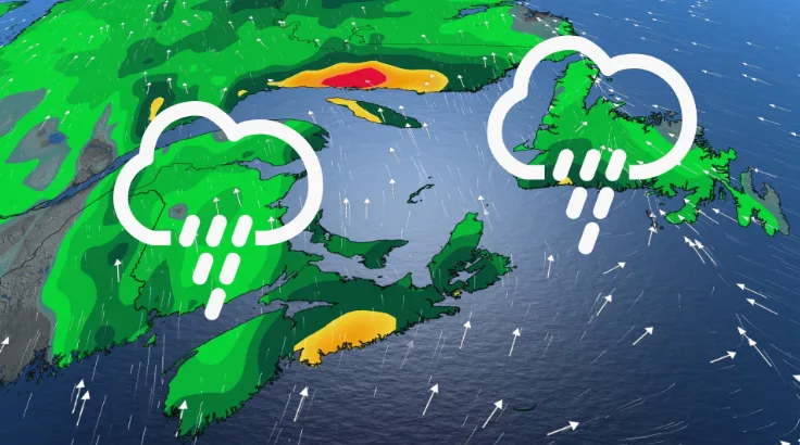
Rainfall warnings are in effect for parts of Eastern Canada as another atmospheric river funnels in subtropical moisture from the south. This event won't be particularly potent, but will be stronger than last week's, which brought days of persistent rain. By the time all is said and done, up to 100 mm is possible in some areas, prompting a rainfall warning and special weather statements for parts of Quebec and Atlantic Canada. As a result, localized flooding in low-lying areas is possible. More on the timing and impacts, below.
First look: Pattern reversal expected as Canada falls into winter
This week: Weather warnings expand with another atmospheric river, heavy rain
Another atmospheric river is funneling heavy moisture northwards into parts of eastern Canada this week.
"Typically we talk about atmospheric rivers that impact coastal sections of the West Coast, but every so often the right ingredients are in place for an atmospheric river to develop on the East Coast," says Matt Grinter, a meteorologist at The Weather Network.

DON'T MISS: Common cold or COVID? How to distinguish between the two
Atmospheric river effects can range from receiving necessary beneficial rain to destructive rainfall events. This event will be slightly stronger than last week's, but will still be on the weaker end of the scale.
The rain will continue to track across the Maritimes through Wednesday night, then across Newfoundland on Thursday as a cold front and upper-level low slowly approaches the region. This low is what will tap into subtropical moisture from the Atlantic, resulting in an atmospheric river event.
MUST SEE: Extreme temperature anomaly scrambles North America's weather pattern
Some areas of eastern Quebec and New Brunswick could receive between 50-100 mm by the time all is said and done. Heavy downpours can cause flash floods and water pooling on roads and localized flooding in low-lying areas is possible.
"Rainfall rates will occasionally be high which will lead to excessive water runoff and water pooling on roadways giving difficult driving conditions," says Environment and Climate Change Canada (ECCC) in the special weather statement that covers parts of the Maritimes.
Residents are urged to also watch for possible washouts near rivers, creeks and culverts. Rainfall amounts will vary as bands of heavier rain move through the region.

Conditions will improve as the front passes, trending warmer for the weekend across the Maritimes. Well above seasonal temperatures are expected to dominate for the final week of October, as well, though Newfoundland could trend cooler at times.
RELATED: Why does your long-range forecast change so often?
WATCH: The science behind atmospheric rivers
Be sure to check back for the latest weather updates across eastern Canada.