
Mighty storm continues to lash the East Coast, but conditions will subside
After a stormy overnight period in the Maritimes and Newfoundland, the weather bomb conditions will gradually get better as Sunday wears on, from west to east.
A fast-strengthening storm made its long-awaited arrival in the Maritimes with gusty winds and widespread heavy rainfall.
After a stormy overnight period in the Maritimes and Newfoundland, the weather bomb conditions will gradually get better as Sunday wears on, from west to east.
DON'T MISS: ‘Weather bombs’ are explosive storms that create ferocious conditions
Similar storms in the past have caused power outages from the winds and hazardous driving conditions from water pooling on roadways and localized flooding, especially in poor drainage areas. Despite a gradual improvement on Sunday, there could still be power outages and poor travel throughout, so plan ahead.
Weather bomb responsible for prolonged storm
Our weekend weather bomb tapped into upper-level winds as it approached the Maritimes on Saturday, and quickly deepened its minimum central pressure through the day.
This sharp intensification into a weather bomb is a process known as bombogenesis, which occurs when a storm’s pressure drops at least 24 millibars in 24 hours. Such a swift drop in air pressure allowed the storm to produce wicked winds and heavy precipitation rates this weekend.
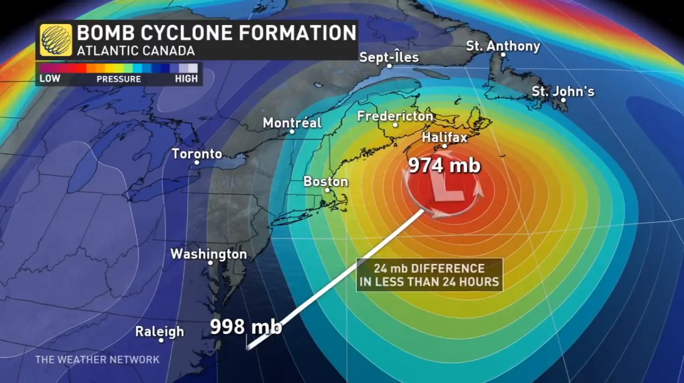
Illustration purposes only.
MUST SEE: Brace for chill: Arctic air oozing into Canada for next week
The storm tapped into a vast reserve of moisture streaming in from the south as it arrives this weekend. At the same time, cold air funnelling in from the west filtered over interior sections of the Maritimes.
Combined, these factors led to a prolonged period of widespread gusty winds throughout Atlantic Canada, as well as bountiful heavy rainfall and the potential for accumulating snows across the west.
Conditions improving Sunday in the Maritimes
Heavy rain and gusty winds arrived in the Maritimes on Saturday afternoon, with conditions rapidly deteriorating in the evening and in the overnight.

However, conditions across the Maritimes will improve in a hurry on Sunday morning as the storm pulls north toward Newfoundland and Labrador.
Due to the high winds and heavy rain in Halifax, this year's Holiday Parade of Lights was postponed until Saturday, Nov. 25, according to the event’s official webpage.
PLAN AHEAD: Staying safe during a power outage
Forecasters saw the highest risk for power outages along the coast from Guysborough County up toward Sydney and the eastern half of Cape Breton Island. A moderate chance for power outages exists around Halifax, Truro, and Charlottetown.

Widespread rainfall totals of 50-80 mm were expected across Nova Scotia, with the most likely centred around Halifax, by the time it wraps up. Heavy rains also extended farther west into New Brunswick and the western end of Prince Edward Island. These areas could see 30-60 mm of rain in the gauges by Sunday.
Colder conditions farther west will allow rain to change over to snow across the northern half of New Brunswick. We’ll see snowfall totals of 5-10 cm across far northern reaches of the province by Sunday morning, with greater totals likely on the Gaspe Peninsula.
Newfoundland and Labrador catch the storm’s worst on Sunday
The leading edge of our potent storm started to push into Newfoundland late Saturday afternoon with rain and gusty winds picking up from south to north.
Conditions then rapidly deteriorated across Newfoundland into early Sunday as the heart of the storm approached the island.

Heavy rainfall and widespread wind gusts of 90-110 km/h are likely on Sunday, especially along coastal sections and immediately inland. Power outages are possible, especially on south-facing coasts around Burgeo and Marystown.
SEE ALSO: When the lights go out, stay lit with these emergency candles
Thankfully, this storm doesn’t plan to overstay its welcome. St. John's will receive 20-40 mm of rain by Sunday afternoon, with winds slowly easing through the afternoon and evening.
While southerly flow will keep Newfoundland above the freezing mark for the duration of the storm, plenty of cold air locked in place over Labrador will make this a solid snowfall event for the region.
Forecasters expect a large swath of 20-30 cm of snow throughout eastern Quebec and Labrador. Happy Valley-Goose Bay is expecting a solid blanket on the ground by the end of Sunday, with 20-40 cm likely.

Looking ahead, blustery and much colder weather will spread over the Atlantic provinces to start the week. Forecasters are watching the potential for another system to approach the region for the second half of next week. Below-seasonal temperatures are expected to stick around for the final week of November.
Stay tuned to The Weather Network for the latest forecast updates in Atlantic Canada.
Thumbnail courtesy of Beverly Quinlan, taken in Birchy Bay, N.L.