
Toronto has yet to hit 20 C this spring, here’s when it could happen

Toronto has been left in the cold this spring without a 20°C temperature, with many surrounding cities having already recorded it. Numerous factors are to blame for the delay.
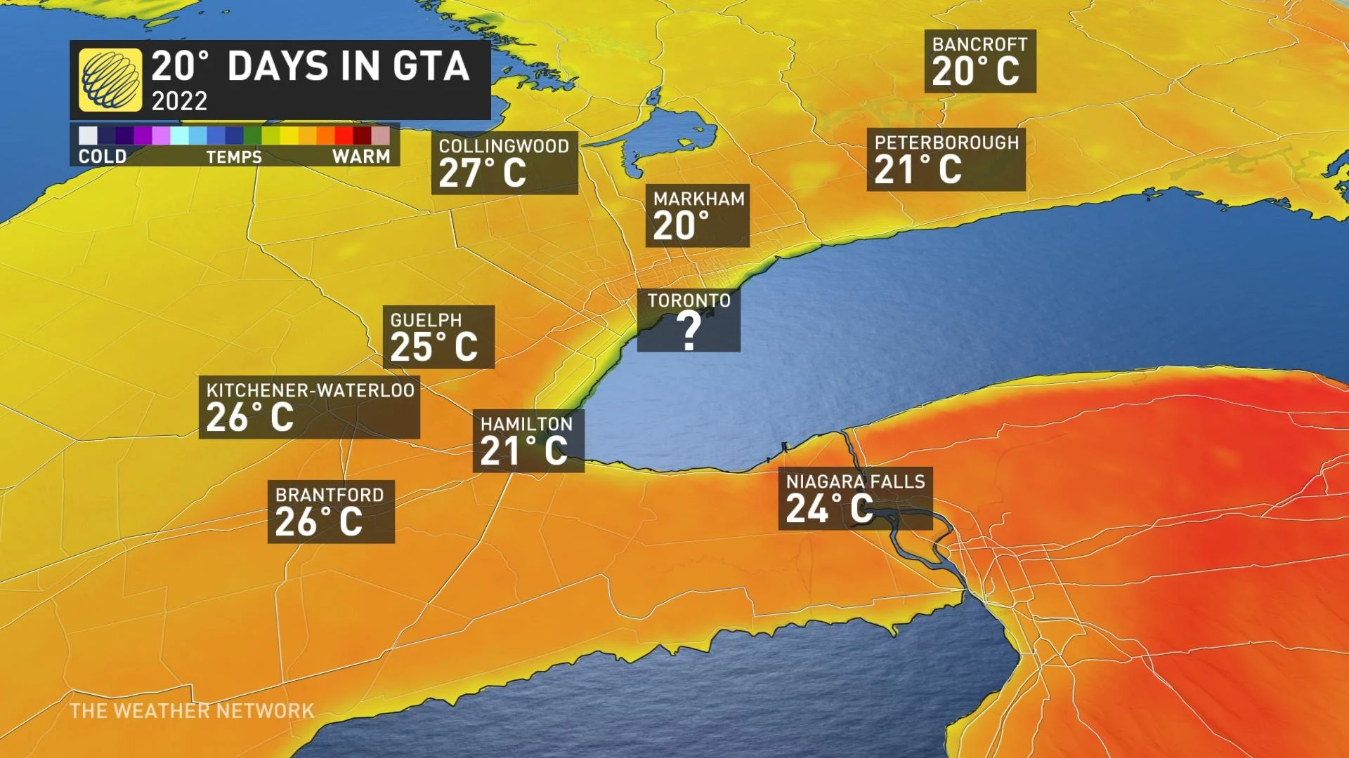
A good chunk of southern Ontario has finally hit that sweet 20-degree mark at least once this spring after this weekend’s pleasant warm-up. Toronto is one of the notable exceptions, however.
Sunday and Monday were realistic chances for the major city to hit the coveted daytime high, but came up short – not the first two times this spring. There is a chance it may not have the opportunity again for the next few weeks, but then again, it may also arise briefly early next week.
A strong blocking pattern is building once again for the end of this month, with no signs of that pattern breaking down during the first half of May. So, as a result, cooler than seasonal temperatures are forecast to dominate across most of Southern Canada in the final week of April and possibly right through the first half of May, as well.
It wouldn’t be out of the ordinary for the first 20-degree day to occur in May for the city, with April looking unlikely this year, but it could have people talking the longer it goes without reaching the temperature.
Even as recently as 2020 its first 20-degree day was May 3.
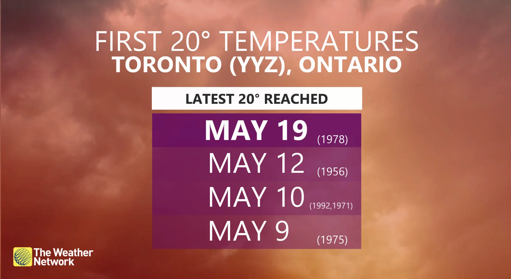
If we don’t hit it by May 3, it will be the latest Toronto has seen the first 20°C since 1993, according to Rachel Modestino, a meteorologist at The Weather Network. And if we don't see it within the first week of May, we have a run at reaching an all-time latest date for it.
Some of the latest dates in the year for Toronto to hit 20°C include May 19, 1978, May 12, 1956, May 10, 1992, May 10, 1971 and May 9, 1975.
HOW SOON COULD WE REACH IT?
While the first week of May is a timeline that may be within Toronto's reach this year, there are many factors working against it including the pesky easterly lake breeze that has been so prevalent this spring in the Greater Toronto Area (GTA).
“Next week will be a roll of the dice when it comes to 20°C weather, as we will need a well-timed sunny break with a southerly breeze to get it, but the odds are beginning to stack up against us,” said Modestino.
Forecasters are eyeing more systems tracking into southern Ontario, allowing for more of the chilly, easterly air off of Lake Ontario. As well, the emerging blocking pattern over Greenland will once again favour colder air over the GTA.
And the reason for that stubborn lake breeze this season?
“The path of weather systems this spring have tracked over Lake Huron and Georgian Bay, northeast of the city. Low pressure draws in air from all sides, and since Toronto is east of the low with this track, the wind is drawn in and generates an easterly wind off of Lake Ontario,” said Modestino.
Winds blowing over the cool waters contribute to communities feeling much chillier than areas a bit farther away from the lakes, even at short distances, as seen this past weekend.
Forecasters will be watching the potential for a brief surge of warmer air early next week, but it will be a bit of a stretch for Toronto to reach that 20°C temperature. And if we don’t reach the 20-degree benchmark in the first week of May, it will be the longest stretch in almost 30 years -- then taking a crack at the all-time record.
With files from Dr. Doug Gillham, Rachel Modestino and Kelly Sonnenburg, meteorologists at The Weather Network.
Thumbnail courtesy of Kris.
Stay tuned to The Weather Network for the latest on when Toronto could hit 20°C for the first time in 2022.


