
Stormy system riding a fine line to determine Newfoundland's snowy fate
A mere 100 km will make or break Friday's snowfall forecast in St. John's, N.L.
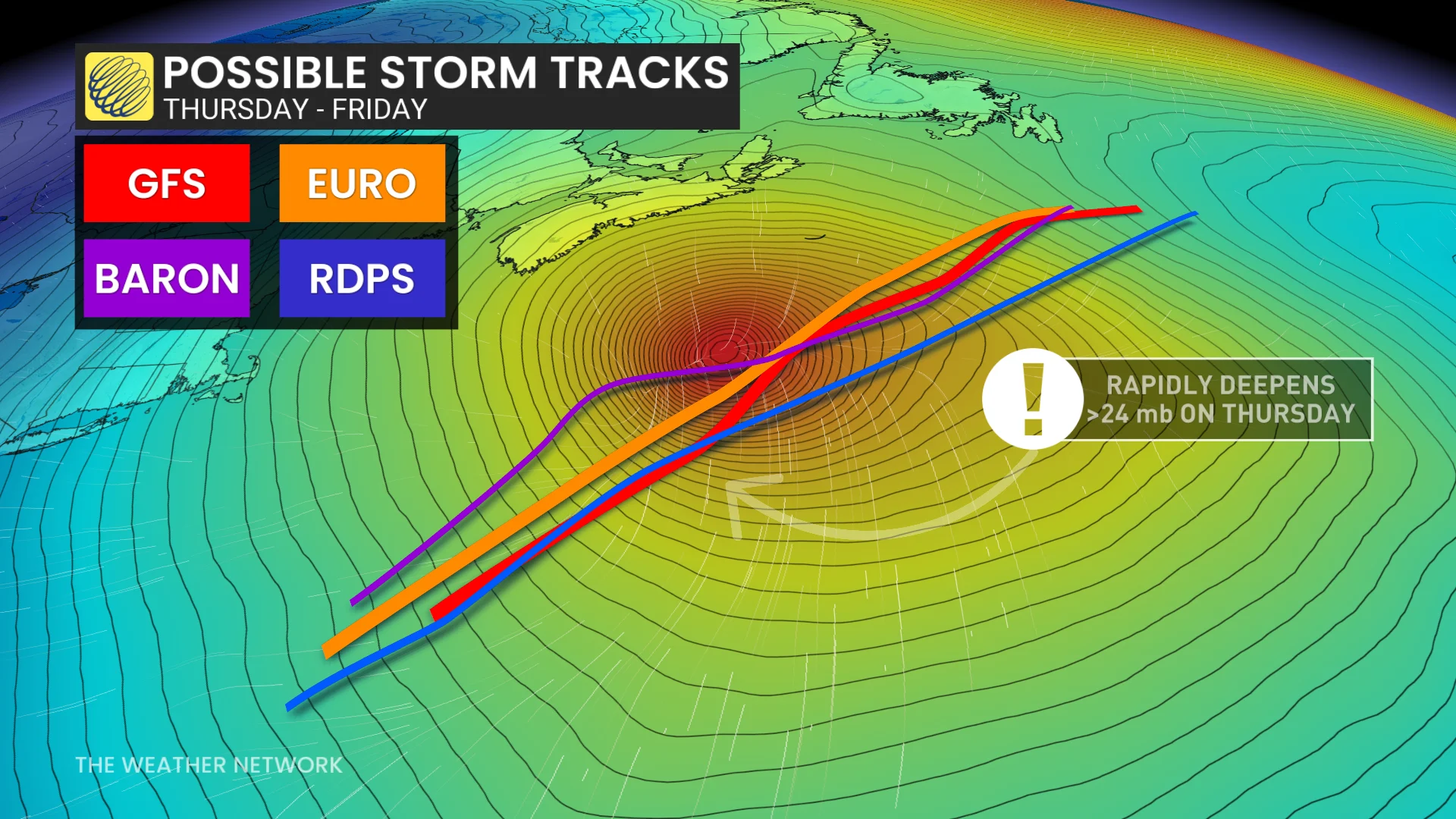
Details of a new storm are coming to light for Newfoundland, but there remains unanswered questions on the exact track and impacts.
One scenario has the island getting a winter blast in time for Friday, whereas the other outcome could merely just bring a dusting of snow.
DON’T MISS: Freezing rain and ice pellets are dangerous winter hazards
How much of a fine line is it? Just a 100-kilometre difference in the track can be a boom-or-bust forecast in St. John’s, N.L., ranging from a dusting of snow to as much as 25 cm.
Make sure you stay up-to-date on your local weather alerts, and be sure to check the latest highway conditions before heading out.
Uncertain track: Will Newfoundland see another shot of heavy snow? Or, will it evade most of the winter blast?
A low-pressure system is forecast to develop in the Atlantic Ocean off the coast of North Carolina on Wednesday and track south of Atlantic Canada on Friday.
The low will undergo bombogenesis from Thursday early morning to early Friday, peaking in strength south of the Maritimes.
The big question, though, is regarding the track of the storm. Will the track of the low be far enough north to bring more snow to the Avalon Peninsula? Or, will it track slightly farther south of Newfoundland, bringing it just a dusting of snow?
Friday: Snow to move into the Avalon
Snow from the system is expected to begin on the Avalon through Friday morning, with the peak rates anticipated to occur in the afternoon before ending in the early-overnight hours.

Wind have a higher confidence of occurring, but there is the potential of 60-80 km/h gusts on the Avalon on Friday, with the strongest expected for southeastern portions.
If the snowfall ends up on the northerly track, the strong wind gusts can reduce visibility, so brace for difficult travel if you need to be on the roads during this time.
With the uncertain track, it will be a tough forecast as 100 km can make or break the snow amounts drastically. Confidence is increasing, however, for folks to see 10-25 cm of accumulating snow, especially around the southeast Avalon.

After a sluggish start to winter, February has been trying to bring St. John’s snowfall up to normal. As of Feb. 18, 86.6 cm of snow has fallen this month––more than the 72.2 cm that fell from October 2024 to January 2025.
Stay with The Weather Network for all the latest on the snow scenario unfolding for Newfoundland.