
B.C. braces for multiple systems that will usher in an abundance of moisture
B.C. braces for multiple systems that will push heavy rain and snow into the region as we kick off December
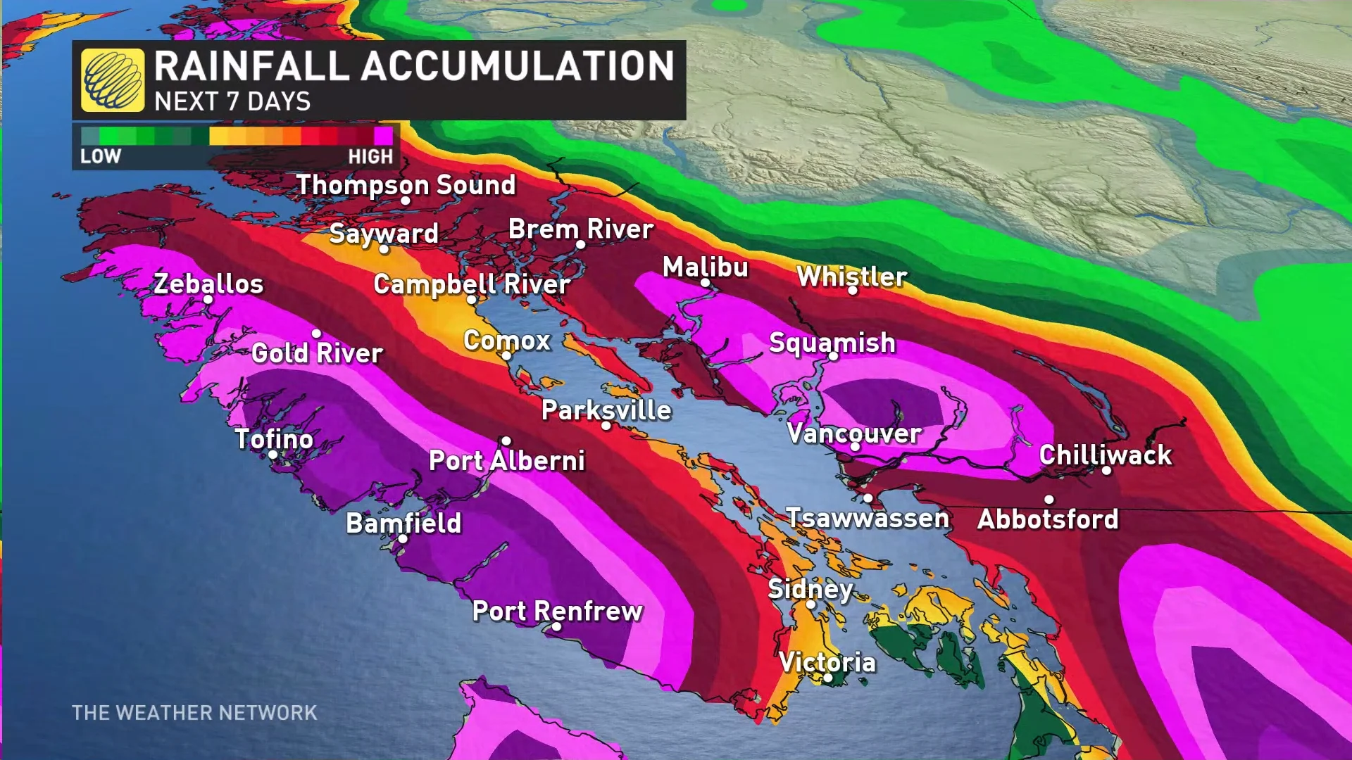
More rain and snow are on the way for B.C., as a pattern flip will bring multiple lows into the province over the next several days.
Although high pressure has dominated the West Coast, delaying the opening of some ski resorts due to the lack of high-elevation snow, that is all about to change.
The pattern will change will push the ridge away from the coast as a trough and a series of low-pressure systems move in. As a result, several days of rain are expected to soak the coastal sections in the lower elevation, while the mountains see snowfall.
DON'T MISS: Canada's Winter Forecast: El Niño a critical factor for the season ahead
Some areas along the coast can expect to see upwards of 60 mm of rain, which nothing out of the ordinary for the region.
As well, B.C. ski resorts in dire need of some help from Mother Nature are about to get a healthy dose of snow.
Thursday
The first low-pressure system will move ashore on Thursday.

The rain won’t be too heavy, especially compared to what B.C. is used to seeing this time of year, but the west coast of Vancouver Island could see upwards to 60 mm by Saturday morning, with lesser amounts in Metro Vancouver and Victoria.
For the eastside of Vancouver island, the system moves in the pre-dawn hours Thursday morning when temperatures will be quite chilly. The Trans-Canada Highway from the Malahat to Highway 19 can expect to see some mixing and even wet snow.

Closer to the Strait of Georgia, the more likely the event will be rain, with a chance of mixing. But, areas west of the highway and higher in elevation, the chance for mixing and wet snow increases.
WATCH: Vancouver Island has a chance for snowfall on Thursday
Friday into Saturday
Another system moves in early Friday with slightly warmer temperatures, which reduces the chance for mixing, but still possible north towards Comox and Campbell River further inland.

Beyond Saturday morning, there are several more low-pressure systems on the horizon that will bring more rain and snow to the region.
That pattern change can bring heavy snow to the mountains, which is very much-needed for ski resorts the open or continue to say open.
However, warmer temperatures to return next week, which could unfortunately bring rain to some of the mountains again.
Sunday and beyond
After the three relatively smaller systems over the weekend, the unsettled active period continues, but really increases in intensity. Another system Sunday comes in with slightly heavier rain, but it also raises freezing levels quite high. This reduces the chance for snow mid-mountain.
After that, an atmospheric river is forecast to develop late Monday into Tuesday night, keeping freezing levels high and bringing heavy rain once again.
Be sure to check back for the latest weather updates across B.C.