Canada's Winter Forecast: El Niño a critical factor for the season ahead

El Niño will be a major contributing factor to how the season ahead plays out
El Niño has a reputation for bringing mild winters to much of Canada and it appears that this winter will feature one of the strongest El Niño events on record. So, can we expect a mild winter across the country this year? The answer is not so simple.
The core of winter—December, January, and February—will begin mildly (relative to this time of year), with most Canadians not experiencing consistently cold temperatures until later in the season.
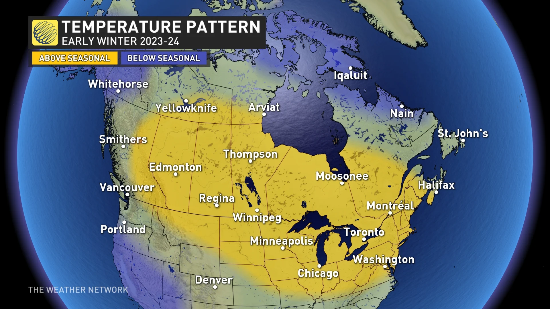
Although many Canadians have already experienced early winter weather, we haven't experienced consistent cold weather, and that pattern will continue well into December. During the weeks leading up to the holidays, we expect near-normal or above-normal temperatures across most of the country. However, it's important to remember that 'normal' temperatures are still cold enough for most places to experience messy winter weather even without a 'consistent' cold pattern.
Based on what we have seen during previous strong El Niño winters, it is possible that a mild pattern will continue to dominate for most of the winter. However, we have several reasons to believe that this winter will break tradition in Canada's eastern half.
The current El Niño event, along with water temperatures in the northern Pacific Ocean, is creating a global weather pattern that is unlike anything we've seen before. Therefore, we believe that the upcoming winter season will deliver some curveballs that will set this winter apart from typical strong El Niño winters.
While mild temperatures should continue to dominate across Western Canada, we expect a different story from the eastern Prairies to Atlantic Canada, where winter could make more than just a token appearance during January and especially February.
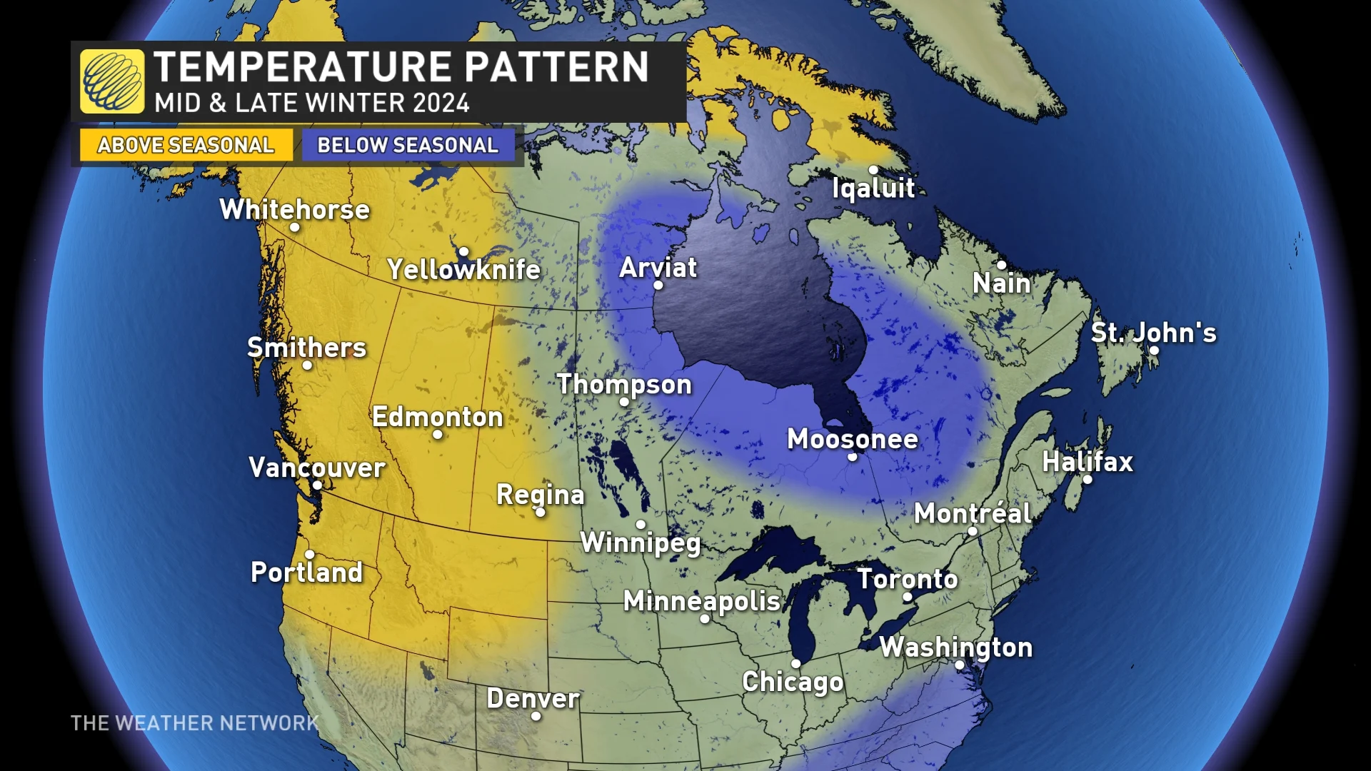
The key to how this winter will be remembered across the eastern half of the country will be whether this pattern will lock in and dominate during January and February or whether the colder pattern will be limited to just a few weeks during the second half of the season (which is yet to be determined).
The current global weather pattern is not behaving as it typically does during a strong El Niño year, and if that continues, then this winter will include a more extended stretch of traditional winter weather.
However, in light of how strong El Niño winters have unfolded in the past, our winter forecast is a compromise between the colder scenario outlined above and the very mild pattern that is typical of a strong El Niño event.
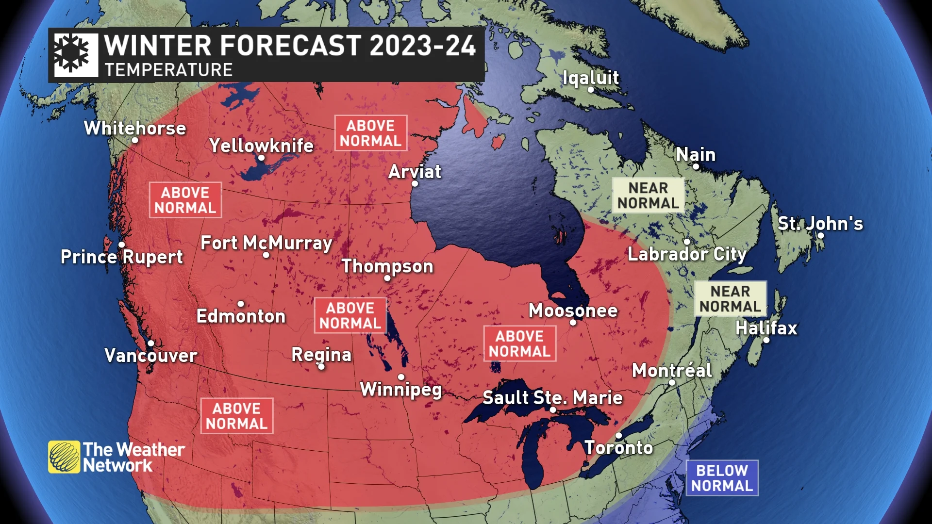
Despite our forecast for widespread above-normal temperatures in December, January and February (see image below), winter is far from being 'cancelled' this year, especially from the eastern Prairies to the Atlantic coast.
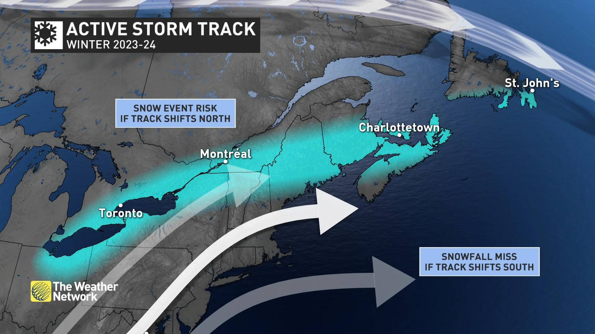
An active storm track is expected across the southern and eastern U.S. coast, and many of these storms are expected to impact Atlantic Canada, resulting in near-normal to above-normal precipitation totals for the season.
Elsewhere across Canada, we expect near-normal or below-normal precipitation and snow totals due to the more southerly storm track.
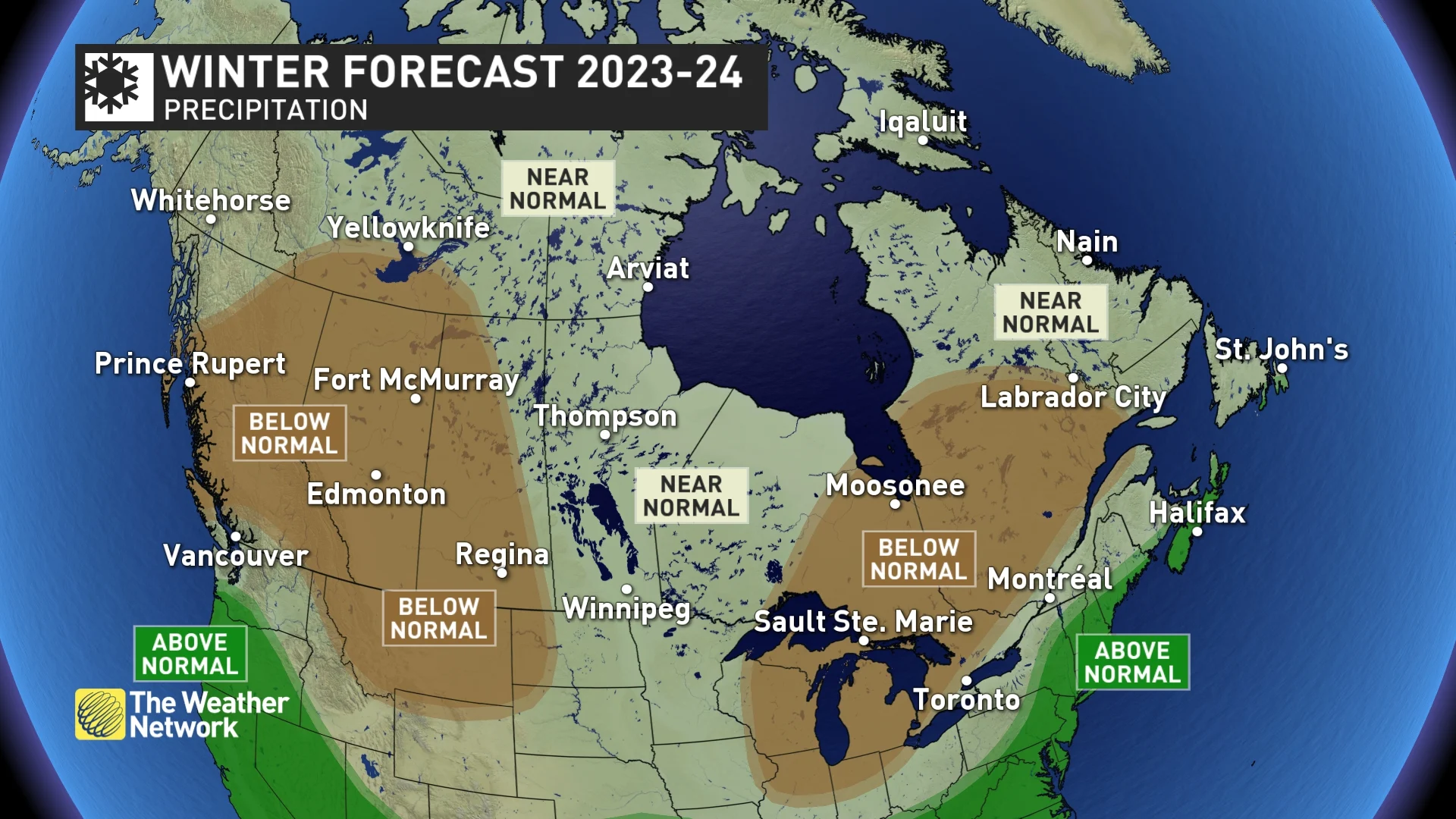
It's worth noting that one region to watch will be southern Ontario and southern Quebec, with a sharp gradient between below-normal and above-normal precipitation. If the storm track ends up being just a little further north than expected at times, then this region would end up seeing a rather active winter pattern.
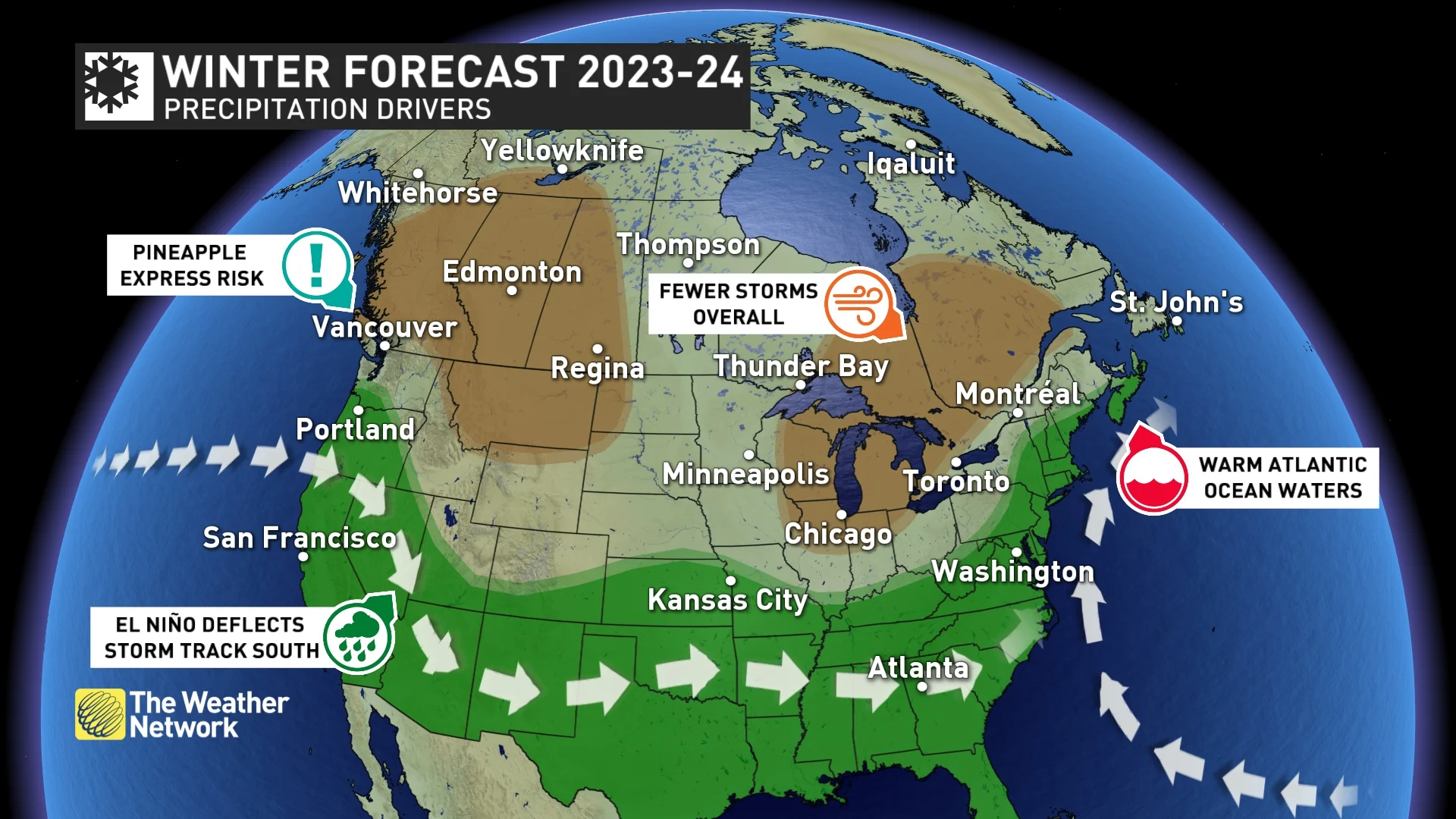
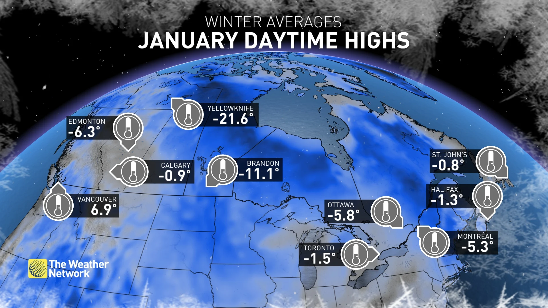
Canada's 2023-24 winter weather drivers. (The Weather Network)
Below is a more detailed look at what you can expect in your province or territory this winter:
British Columbia
A classic El Niño winter pattern is expected across B.C. Above-normal temperatures are likely, as mild Pacific air will dominate the pattern. While arctic air will be felt at times, we expect fewer and shorter Arctic outflow events into the Vancouver and Victoria area compared to what we usually see during a typical winter.
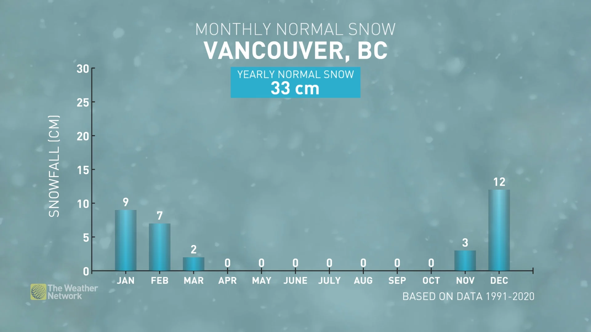
Typically, with El Niño, the dominant storm track tends to stay south of the border in California. Therefore, we expect that most of the province will see below-normal precipitation, below-normal snowfall, and more sunshine than we typically see during the winter.
However, we do think that for the south coast region, the dry pattern will be broken up at times by periods of wet weather, with a heightened risk for “Pineapple Express” events, which would bring heavy rain to the region, and a risk for rain to extend into the alpine regions.
Therefore, we expect that this region will still see normal precipitation totals, despite having fewer rainy days and fewer storms overall. However, snow totals for the south coast region should still be below normal due to milder temperatures.
WATCH | B.C.'s 2024 Winter Forecast: What does El Niño mean for ski season?
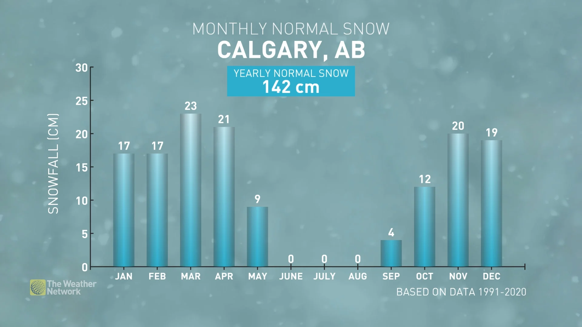
Alberta
A relatively mild winter is expected across Alberta, including Edmonton and Calgary, with above-normal temperatures and below-normal snow totals. Of course, there will still be periods of high-impact winter weather, but mild Pacific air is expected to be more prevalent than Arctic air.
It is still much too early to make a call on who will see snow on the ground for Christmas. However, it looks like we will see a relatively mild and dry pattern during the weeks leading up to Christmas. As a result, we think that some places that typically see a white Christmas will be at risk of a rare 'brown' Christmas this year.
During mid- to late-winter, we expect that a cold pattern will develop well to the east of Alberta. If the focus of the cold weather shifts further west than what we currently expect, then Alberta could end up seeing a more active pattern (potentially more snow) and periods of more significant cold weather.
Saskatchewan and Manitoba
A milder than normal winter is expected across the region, especially across western Saskatchewan, as Pacific air will spread into the region from the west. However, there will still be periods of severe cold, especially during January and February across eastern parts of the region, including Winnipeg. But frigid conditions are not expected to be as persistent as they are during a typical winter.
Typically, residents of this region are almost guaranteed a white Christmas, and most should see a white Christmas again this year. However, there is a risk that a relatively mild and dry pattern in the weeks leading up to Christmas will result in a rare 'brown' Christmas for parts of the region.
Below-normal snowfall is expected across western Saskatchewan, but eastern parts of the province and Manitoba are expected to see near-normal snow totals.
WATCH | Prairies' 2024 Winter Forecast: Will winter bring any drought relief?
Ontario
A mild start to winter is expected, with less snow than normal during the weeks leading up to the holidays, especially in the southern parts of the province, including London, Hamilton, Toronto, and Ottawa. However, if you are dreaming of a white Christmas, don’t give up hope! It looks like a more wintry pattern will develop around the holidays.
As we head into the heart of the winter season, the question is whether we will return to a mild pattern for most of January, which is what we would typically see with a strong El Niño, or whether a more traditional winter pattern will develop for January. At this point, we think that the colder scenario is more likely.
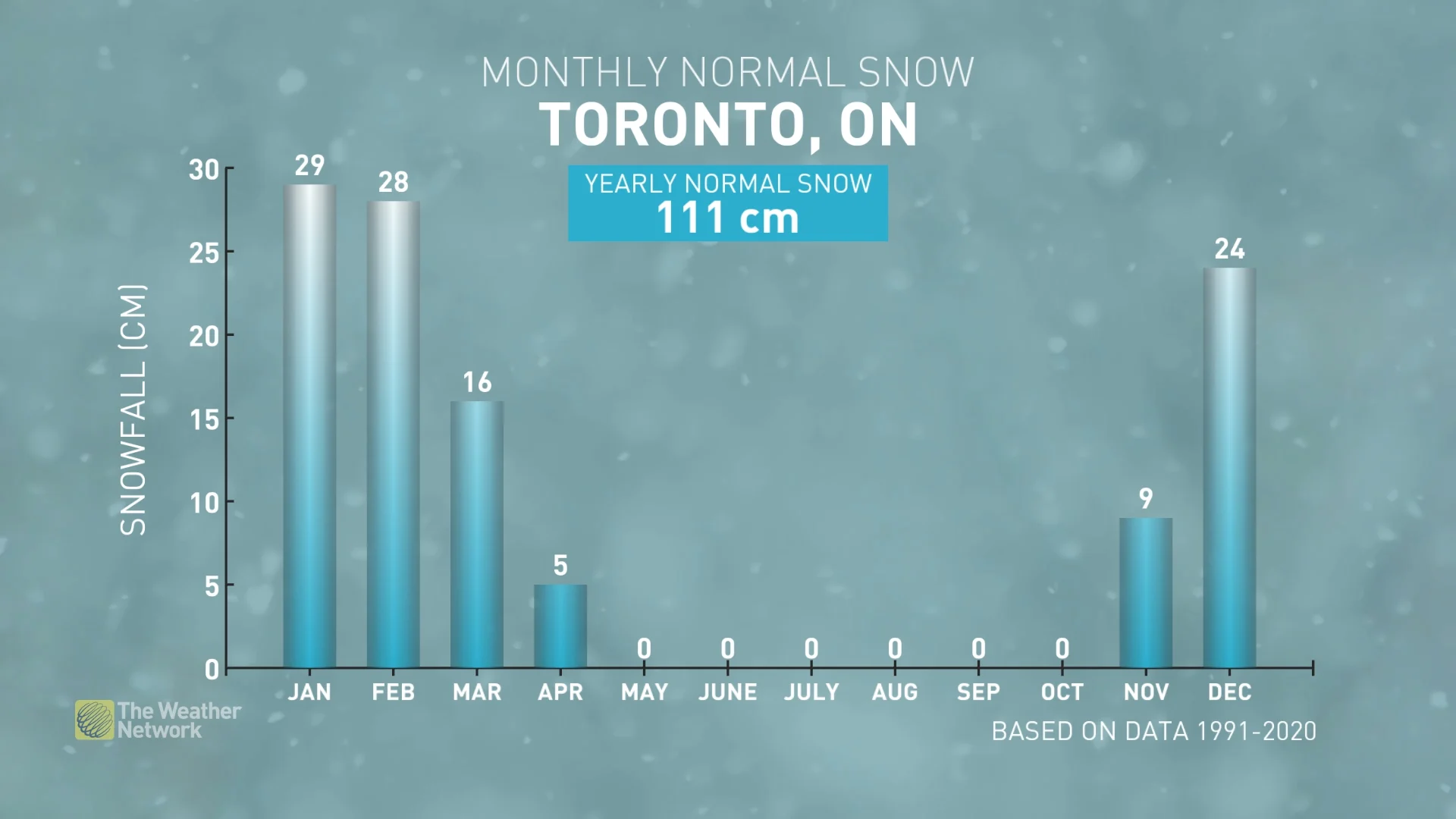
When the colder weather arrives, the Great Lakes will be wide open, so the traditional snowbelt areas should eventually see an abundance of lake-effect snow.
The primary storm track for the season is expected to be well south of the border but close enough to bring near-normal snow totals to the southernmost parts of the province. However, a slight shift north or south would have a major impact on the final totals (this is to be determined).
WATCH | Ontario's 2024 Winter Forecast: Not a typical El Niño winter
Quebec
A relatively mild start to winter is expected, especially for western parts of the province, including Montreal, during the weeks leading up to the holidays. However, if you are dreaming of a white Christmas, you will be glad to know that there are indications of a more wintry pattern developing around the holidays.
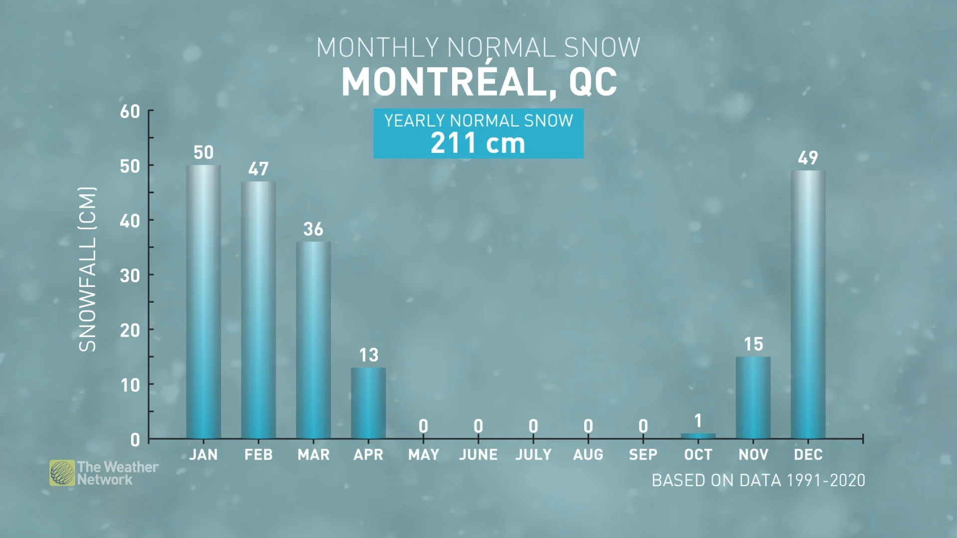
As we head into the heart of the winter season, the question is whether a mild pattern will return for most of January, which is what we would typically see with a strong El Niño, or whether we will see a quick transition to a more consistently cold winter pattern. At this point, we think that a quicker transition to a colder pattern is more likely.
The primary storm track for the season is expected to be well south of the border, but close enough to bring areas near and south of the St. Lawrence, close to normal snow totals for the season, including Montreal, Sherbrooke, and Quebec City. However, a slight shift north or south would have a major impact on the final totals.
WATCH | Quebec's 2024 Winter Forecast: Will El Niño bring a mild winter?
Nova Scotia, New Brunswick, and Prince Edward Island
A changeable, but overall near-normal, winter is expected across the region. We expect that periods of mild weather will potentially be offset by periods of cold weather, which would result in near-normal temperatures overall.
An active storm track across the southern and eastern U.S. will take many storms out to sea rather than directly into Atlantic Canada. However, a few moisture-laden systems are expected to impact the region and bring near-normal or slightly above-normal snow and rain totals to the region.
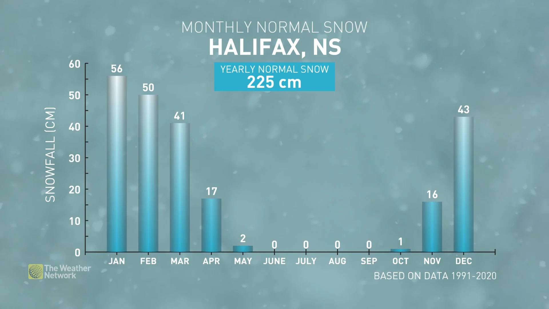
While the dominant storm track should be south of the region, a few winter storms are expected to take a more northerly track through or north of the Bay of Fundy. When this happens, the warmer than normal ocean water temperatures will contribute to significant thaws with very mild temperatures and heavy rain for at least southern parts of the region, including Halifax.
WATCH | Atlantic Canada's 2024 Winter Forecast: What a southern storm track means for the East Coast
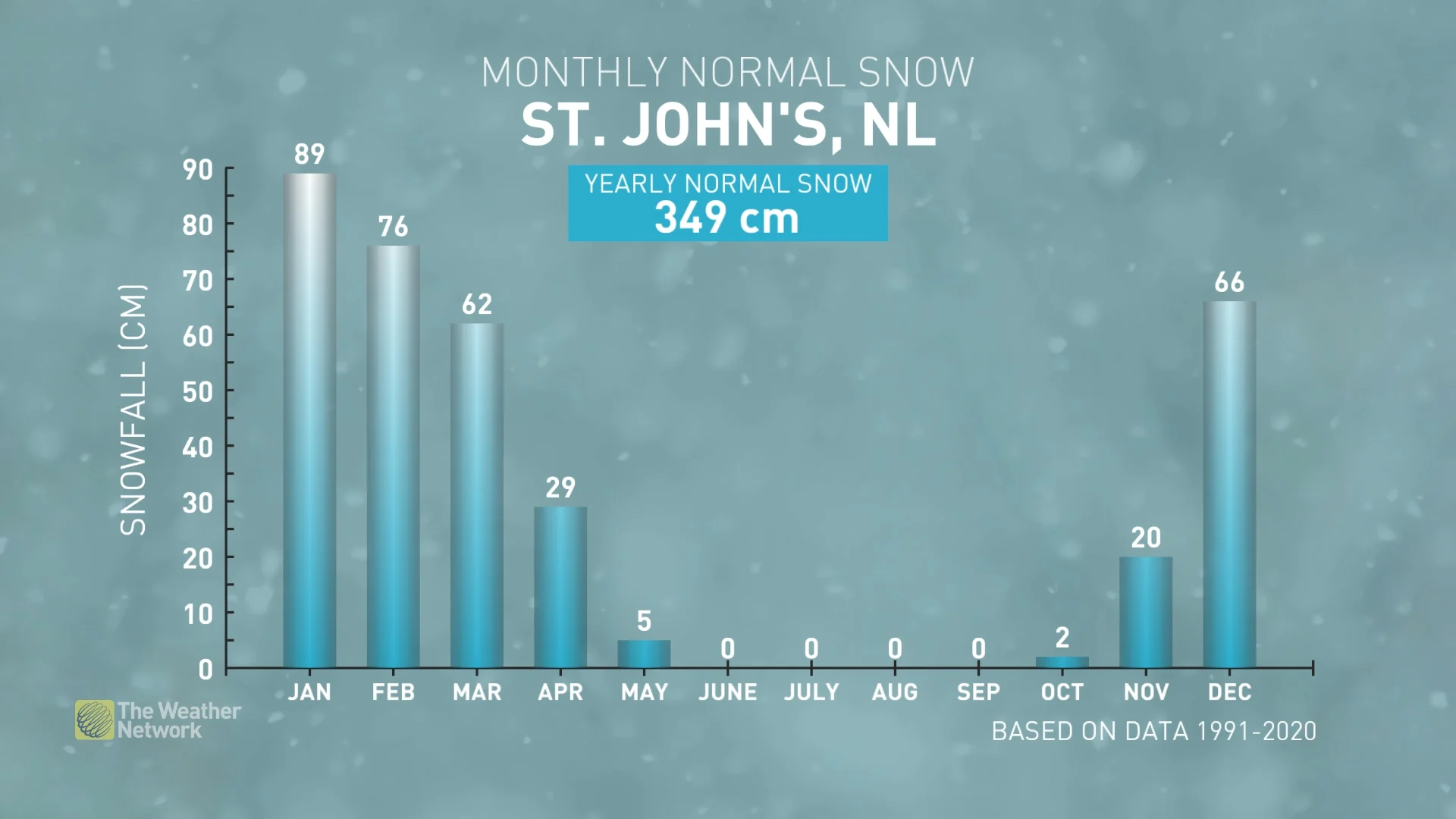
Newfoundland & Labrador
A changeable, but overall near-normal winter is expected across the region. Periods of mild weather should be offset by periods of cold weather, resulting in near-normal temperatures overall.
An active storm track across the southern and eastern U.S. will take many storms out to sea rather than tracking directly into the region. However, enough moisture-laden systems are expected to impact the region to bring near-normal precipitation totals to the region, including St. John’s and Corner Brook.
Yukon, Northwest Territories and Nunavut
Milder-than-normal temperatures are expected across most of the region, but a cold start to winter across Alaska could spread into the Yukon at times.
As we get deeper into winter, we are watching the potential for a piece of the polar vortex to sit over northern Hudson Bay and Baffin Island, which would bring a period of colder than normal temperatures to those areas.