After strong storms Wednesday, more overnight storms possible in Ontario

Two rounds of strong storms already manifested through the day Wednesday, and though there's still some uncertainty, an overnight round looks set to make an appearance.
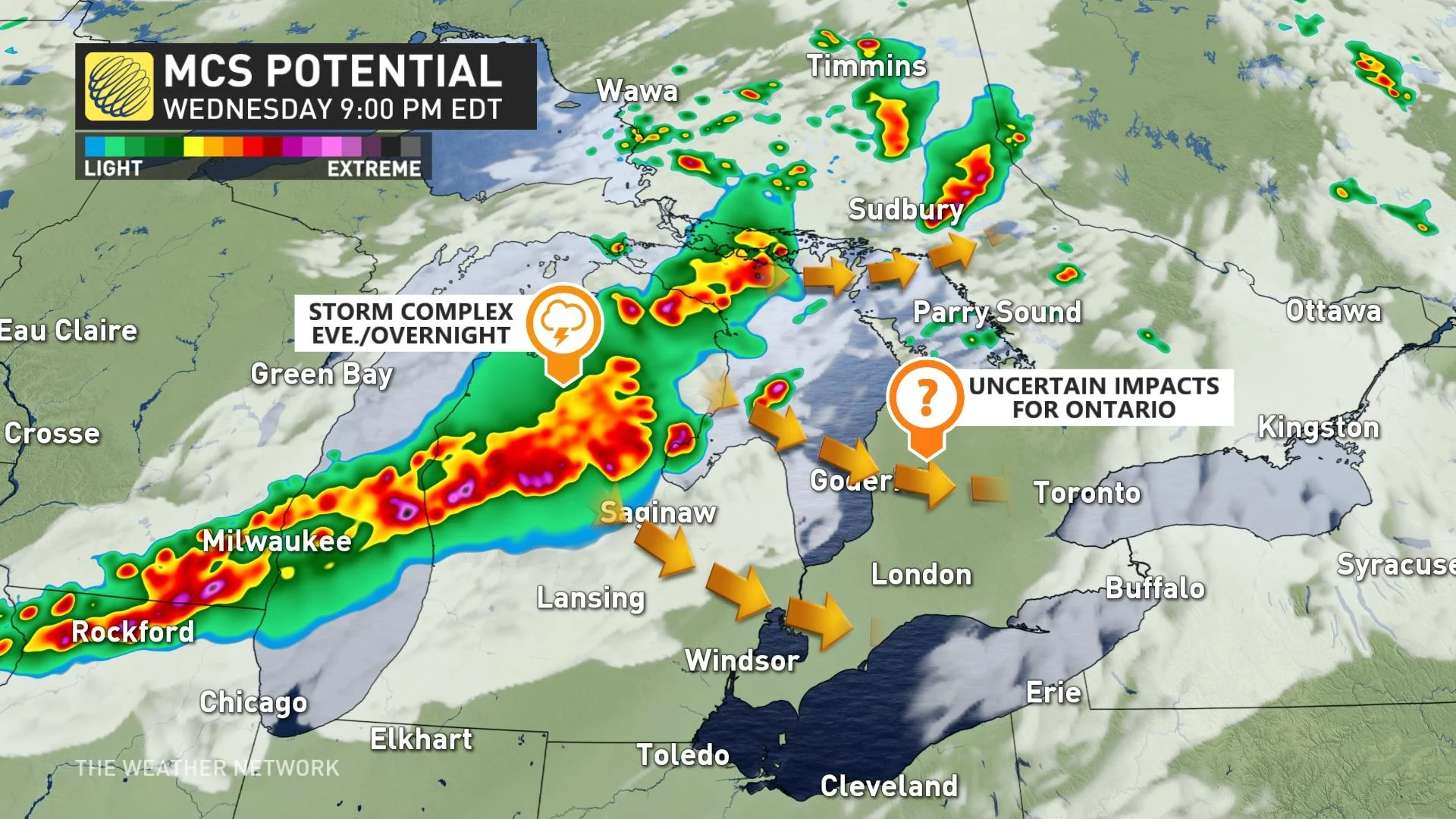
After a day of at-times severe storms that damaged structures and downed trees in southern Ontario, forecasters are warning that a strong complex of storms developing in the midwestern U.S. may spill over into southern Ontario in the evening and overnight hours. The risk zone will be the southwest and GTA. Damaging winds and hail will be possible in areas where storms turn severe, and the risk of a tornado or two has not been ruled out. More on the timing and impacts expected, below.
INTO THURSDAY: HEAT, HUMIDITY LOCKS IN ACROSS THE SOUTH, STORM RISK LINGERS
Wednesday's storms began with an early-morning round in the southwest, and an afternoon encore resulted in thousands of power outages and damage to structures and trees, though no injuries have yet been reported.
The risk is not over yet, however: a more organized band of storms may push in from the northwest into the overnight hours as a weak front presses in, providing a bit more of a focused trigger mechanism for storm development, and it is this potential that has forecasters particularly watchful, though there is somewhat high uncertainty.

MUST SEE: Why nocturnal thunderstorms can be particularly dangerous

If this storm complex develops, it would bring a risk for large hail and damaging wind gusts. Heavy local downpours are also possible, and the risk of a tornado or two has not been ruled out.
Meanwhile, in the south, the searing heat and high humidex values continue into Thursday, with the Niagara region and Greater Toronto Area seeing 30-degree daytime highs and a humidex exceeding 40.
Just to put that into perspective, Toronto’s hottest day so far this year was June 6, which saw a daytime high of 33.8°C.
A heat warning was issued for much of southern Ontario, urging residents to reduce any heat-related risks, drink plenty of water and remain in a cool place.

"Extreme heat affects everyone," says Environment Canada in the warning. "The risks are greater for young children, pregnant women, older adults, people with chronic illnesses and people working or exercising outdoors."
LOOK AHEAD: ANOTHER LATE-WEEK CHANCE OF STORMS BEFORE FRESHER, PLEASANT WEEKEND
The hottest week of the summer continues through Friday with tropical humidity and feels-like values near 40, and a few rounds of thunderstorms with torrential downpours expected.

A cold front will approach the region on Friday and sink south of the region for the weekend. A final round of thunderstorms is likely ahead of the cold front with strong to severe storms possible.
Relief from the heat and humidity is anticipated for this weekend, with abundant sunshine, low humidity, and much more comfortable temperatures. In fact, daytime highs will be a couple degrees cooler than seasonal in some areas.

Pleasant weather continues early next week, with partly sunny skies and a warming trend.
Check back as we continue to monitor the forecast in southern Ontario.