Ontario thunderstorm threat builds with the heat and humidity
Stay alert for rapidly changing conditions if you have outdoor plans over the next couple of days
Thunderstorms kicked off the long weekend across parts of Ontario as an active pattern takes shape over the region.
Expect additional opportunities for thunderstorms to develop in the days ahead as warmer and more unsettled conditions spill across the Great Lakes.
Stay close to safe shelter if you have outdoor plans this weekend. If you can hear thunder, you’re close enough to get struck by lightning.
DON'T MISS: Latest forecast warns a very strong El Niño could emerge soon
Sunday, Monday storm threats for parts of northern Ontario
Most folks across Ontario will escape the rain and storms during the day Sunday. A centre of low pressure tracking toward northwestern Ontario will bring the threat for rain and thunderstorms into the overnight hours for communities near the Ontario-Minnesota border.
Thunderstorms may build over northeastern Ontario ahead of a warm front during the overnight hours Sunday into Monday. Heavy rainfall will be the primary threat with larger clusters of storms that move across the region through early Monday morning.
Additional thunderstorm activity is in the forecast Monday afternoon across northern Ontario as the low-pressure system continues to advance northward.
Tuesday storm threat builds in central, southern Ontario
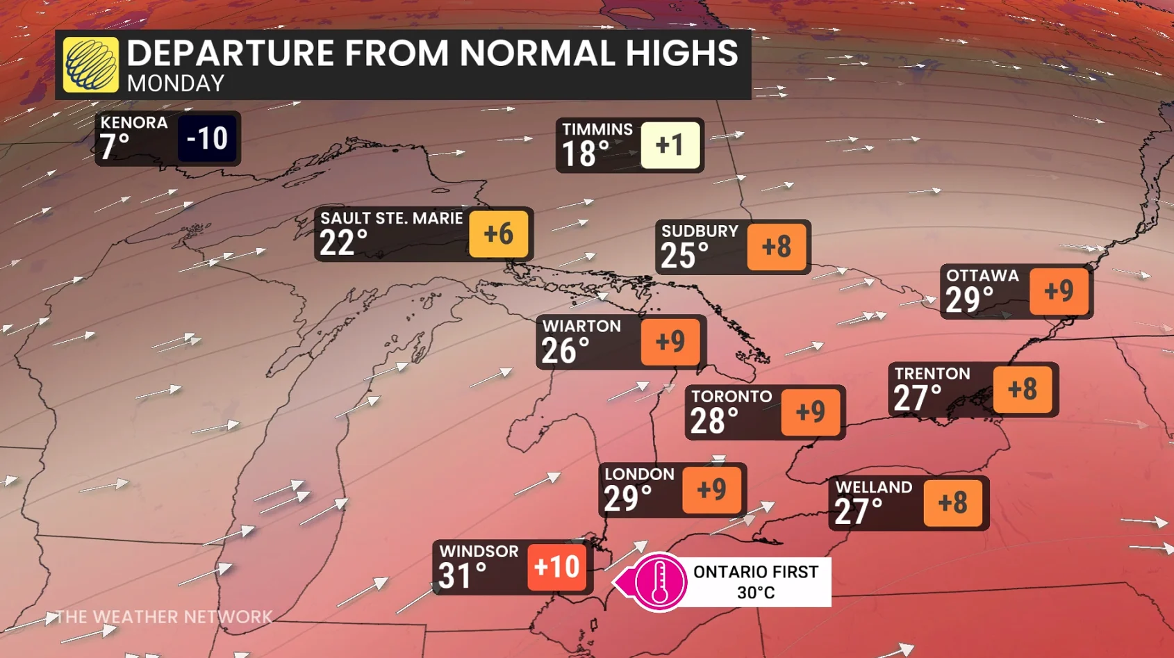
Instability will build across the southern half of Ontario during the day Tuesday as heat and humidity parks across the region. Forecasters expect the province’s first 30°C of the year to arrive on Tuesday.
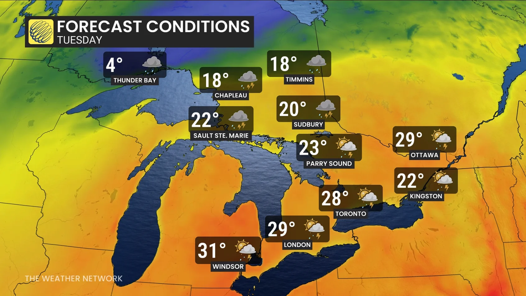
The low-pressure system’s associated cold front will sweep into this unstable air and help fuel thunderstorm development over central and southern Ontario.
Heavy rainfall will be the primary threat, along with a risk for small hail and gusty winds. Storms are forecast to be isolated in nature, mostly triggered by lake-breeze boundaries and modest convergence.
The cold front is expected to move through by early Wednesday morning, prompting non-severe storms across the region.
Thunderstorm safety is vital on a holiday weekend
A warm holiday weekend guarantees that plenty of folks will spend time outdoors in the days ahead, making thunderstorm safety paramount.
Lightning can strike dozens of kilometres away from the heart of a storm. If you’re close enough to hear thunder, you’re close enough to get struck by lightning. If someone nearby is struck by lightning, don’t wait to render aid! It’s a myth that it’s dangerous to touch a lightning strike victim.

Severe weather can strike suddenly. Flying debris and falling trees are a significant hazard during a storm’s sudden high winds. Large hail is dangerous to anyone caught outdoors.
Make sure you have a way to receive severe weather warnings the moment they’re issued.
Header image created using graphics and imagery from Canva.