First bout of accumulating snow in southern Ontario challenges drivers

Nothing says ‘October in Ontario’ quite like the first winter weather travel advisories of the season.
A chilly pattern lodged over Central Canada this week is making its grand finale through Thursday, with the potential for lake-effect snow squalls across portions of southern Ontario.
DON’T MISS: First look: Pattern reversal expected as Canada falls into winter
We’ve dealt with a solid bout of chilly air across Ontario for the past couple of days, with daytime high temperatures running 5 to 8 degrees below seasonal for this point in October.
This unseasonable cooldown allowed for a decent early-season snow for communities east of Lake Superior, where some folks picked up 5 to 10 cm on Tuesday.
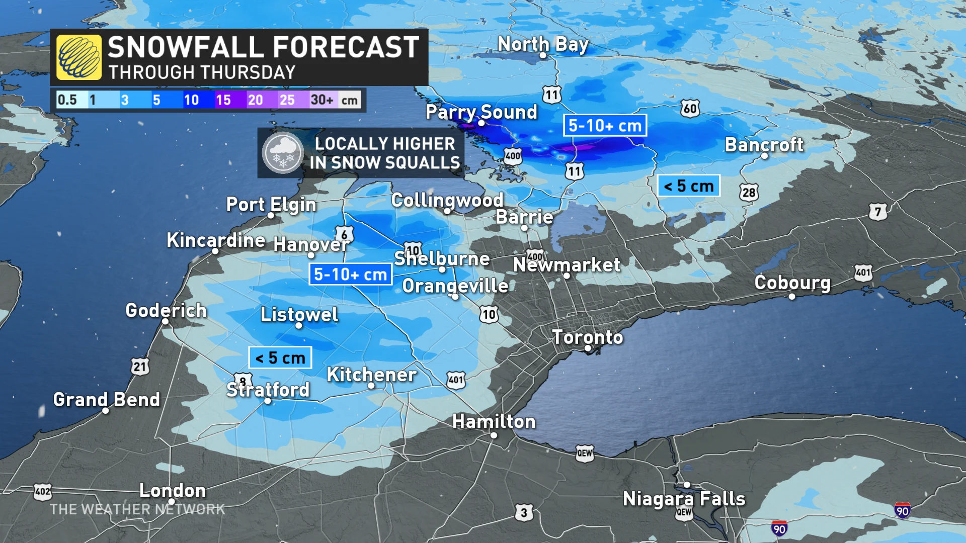
A fresh round of snow is in the forecast through our Thursday as the cold air combined with brisk southwesterly winds blow across southern Ontario.
This setup could lead to several lake-effect snow squalls blowing off of Lake Huron and Georgian Bay.
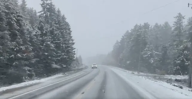
The best chance for snow will cover higher elevations in southern Ontario, as well as communities east of Georgian Bay up in cottage country. These bands could be on the heavier side at times, which could lead to low visibility and slick roads at times.
"A combination of high snowfall rates along with elevation means snow is accumulating on the roads north of Durham," tweeted The Weather Network's Storm Hunter Mark Robinson Thursday morning. "Be careful if you haven’t got winter tires on yet."
Environment and Climate Change Canada (ECCC) also issued the season’s first winter weather travel advisories ahead of the threat for snow through Thursday.
“Motorists should expect hazardous winter driving conditions and adjust travel plans accordingly. Prepare for quickly changing and deteriorating travel conditions,” ECCC said in its advisory.
The agency added: “Snow squalls cause weather conditions to vary considerably; changes from clear skies to heavy snow within just a few kilometres are common.”
We could see snowfall totals of 5 to 10 cm by the end of the day on Thursday across areas that experience the most potent snow squalls, which is most likely with the squall off of Georgian Bay.

It’s still early in the season and temperatures will hover just on either side of freezing, so some snow will melt on contact with the ground, reducing the amount of accumulation you see all at once.
Elsewhere, temperatures will remain above freezing for the majority of lower elevations across southern Ontario, allowing Thursday’s precipitation to fall as a cold, dreary rain.
Precipitation will ease altogether into Friday morning as the upper-level low and its surface features pull off to the east.
MUST SEE: Common cold or COVID? How to distinguish between the two
While the November-like weather will dominate much of this week, forecasters are watching the potential for a much warmer end to the month.
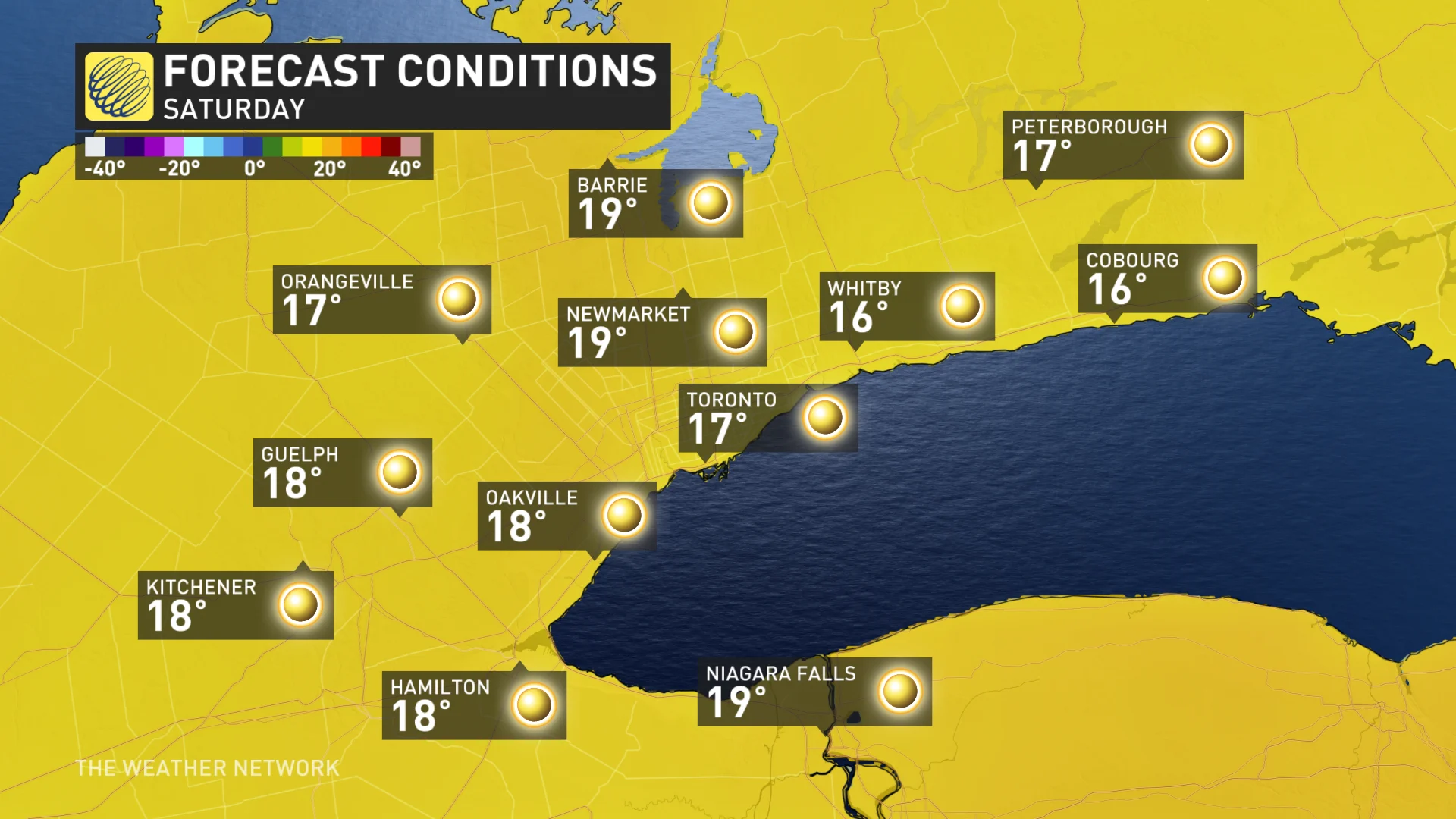
Spectacular fall weather is expected this weekend across the south, with abundant sunshine and well above seasonal temperatures. Daytime highs will reach the mid to upper teens with a few spots possibly hitting 20°C. Warmer than normal temperatures are set to dominate through the final week of October.
WATCH: Slushy snowfall in southern Ontario is a grim reminder of winter
Stay tuned to The Weather Network for the latest forecast across Ontario.