
Damaging winds, intense rain hit parts of the East Coast with threat for 200+ mm
A powerful storm with subtropical moisture and strong winds is blasting through Atlantic Canada, with serious ramifications for power and travel this week
Widespread warnings remain in effect as a potent and moisture-packed storm wallops Atlantic Canada this week. Thousands were left in the dark with the combination of howling winds and rain on Monday, and Marine Atlantic cancelled Monday's ferry crossings between North Sydney, N.S., and Port aux Basques, N.L. The Tuesday morning sailing was cancelled as well, with storm impacts set to linger into Wednesday for many.
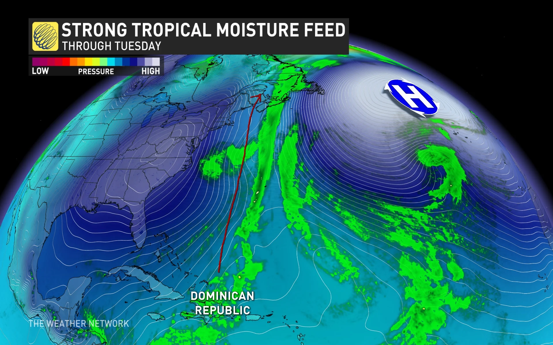
This isn't just an ordinary system, either. A highly anomalous stream of moisture for mid-December is sweeping the East Coast, all the way north, and into Labrador.
WINTER 2024: El Niño will play a critical role in the weeks ahead
More than 100 mm of rainfall is possible in southeastern Nova Scotia by the time all is said and done, while there is the potential for up to 200+ mm of rainfall through Thursday in parts of southwestern Newfoundland.
According to Environment and Climate Change Canada (ECCC), similar storms in the past have caused numerous instances of flash flooding, fast-flowing water, often at levels exceeding river banks, washouts and closures of roads and bridges, interruption of transportation networks, strain on emergency response and public services, mudslides and landslides and lengthy recovery times, depending on nature of damage incurred.
RELATED: Thousands still without power as rainfall, wind warnings continue in Nova Scotia

Days of rain as an atmospheric river funnels in extreme moisture
An extreme pattern in the atmosphere is going to lock an atmospheric river across the Maritimes through much of the week, as a strong high-pressure system funnels up moisture from as far south as the Dominican Republic.
Through Wednesday, the atmospheric river will target eastern Nova Scotia and southwestern Newfoundland, increasing the threat for flooding with very few breaks in between.
Over 40 mm has already fallen in Halifax, N.S., with 65 mm reported in St. Stephen, N.B. since Monday. A peak wind gust of 107 km/h also hit Greenwood, N.S., with other areas reaching 90 km/h. According to Nova Scotia Power, over 50,000 customers were still without power as of Tuesday morning, with over 100,000 still in the dark across New Brunswick, as well. The outages also closed many schools across the province.
RELATED: Ferries cancelled, bridge restrictions possible in face of wind warning on P.E.I.
Monday’s heavy rain and gustiest winds in the Maritimes will subside for most, but will persist along a stationary front draped over eastern Nova Scotia and Newfoundland’s Burgeo shores. Rain and wind will continue into Wednesday because of this unusually strong, wet and blocked set-up.
We're watching areas east of Halifax to exceed 100 mm of rainfall by Wednesday, with widespread 50-75 mm of rainfall forecast across southwestern New Brunswick. Across southwestern Newfoundland, upwards of 200 mm+ of rainfall is possible through Thursday. This amount of rain could lead to some flooding and road washouts.
Drivers are being urged to be extremely cautious of any water on the roads, and to remember, "turn around, don’t drown."

SEE ALSO: Over 100,000 N.B. Power customers without power, trees down, dozens of schools closed
One of the many unusual aspects of this storm is that St. John’s will largely miss this system’s rain due to that ridge of high pressure over the ocean. A stray shower is possible, but compared to the western half of Newfoundland, the Avalon will not be impacted.
The winds in eastern Nova Scotia and Newfoundland will remain very strong on Tuesday, with widespread gusts between 60-80 km/h likely, and some coastal sections possibly reaching 90 km/h.

Colder temperatures and snow with next late week system
Another system is likely to affect the eastern Maritimes on Thursday. While confidence is low, that could pad rainfall totals through the week.
Colder air will also press south into the region, so rain will change to heavy snow across western and northern Newfoundland and eventually spread across much of the province later in the week. Snow totals for western and northern Newfoundland could be quite impressive.
We're also closely watching the potential for significant snow for the eastern Maritimes, possibly including PEI. The storm track is still uncertain, but parts of the region should end up with a white Christmas.
Stay with The Weather Network for the latest updates across Atlantic Canada.