First significant Great Lakes waterspout outbreak of the season

Cooler air spreading into central Canada will heighten the threat for waterspouts, thunderstorms, and windy conditons this week.
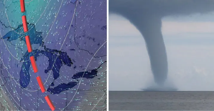
The first significant Great Lakes waterspout outbreak of the season is upon us, as a broad upper level trough creeps across Ontario this week bringing the threat for multiple days of waterspouts, pesky rain showers and isolated pop-up thunderstorms. A chillier temperature trend will also mark the first half of the week, with the threat for frost lingering outside of urban areas. More more on what the final week of September will bring, read below.
Visit our Complete Guide to Fall 2022 for an in-depth look at the Fall Forecast, tips to plan for it and much more!
This week: Pesky rain showers and waterspouts
The fall season certainly wasted no time kicking into high gear, as temperatures took a significant tumble last week, remaining cooler as we start this final week of September.
"These types of weather patterns will bring a little bit of everything including sunshine, cloud, showers and thunderstorms," says Kelly Sonnenburg, a meteorologist at The Weather Network. "Temperatures are crisp, but can always temporarily warm when the sun shines. They make it extremely difficult to plan your outfit for the day."

Along with the cooler, early October-like temperatures, will be the threat for waterposuts as an upper level low pressure system tracks over the warm waters of the Great Lakes sparking the risk for waterspouts to develop.

According to Sonnenburg, this will be the first significant waterspout outbreak of the season across the Great Lakes.
As of Monday morning, numerous waterspouts had already be spotted across Lake Erie.
This specific weather pattern is expected to stick around through Wednesday before pushing east and making way for the return of drier conditions late week and into the weekend with high pressure.
The next round of precipitation expected early next week could be the remnant moisture from Hurricane Ian, however this is not a complete guarantee as not all long range computer models have it tracking into the Great Lakes.
A milder pattern is expected to return and dominate during early and mid October.
WATCH: Waterspout spotted over Erie amid multi-day threat for Great Lakes
Be sure to check back for the latest updates across Ontario this week.


