Manitoba buried in epic snowstorm, 70 cm possible for some

Closed roads, snapped trees, downed power lines, and thundersnow. Things are really ramping up in southern Manitoba
Parts of Manitoba are just about vanishing beneath a winter storm that would be considered extreme even if it weren't unusually early. Friday featured the worst of the storm, but there are still more than a few flakes to fall into Saturday, while other parts of the province are in for torrential downpours.
More on the timing of this system and just how much snow this system threatens, below.
Canada's Thanksgiving weekend forecast: You may need to plan ahead
WEATHER HIGHLIGHTS
Lighter snow Saturday, though still significant for some areas
Persistent winds will make for lingering blizzard conditions
Areas east of Winnipeg to see heavy downpours through Saturday, rainfall warnings in effect
Stay up-to-date on the ALERTS in your area
WATCH BELOW: TIMING OUT THE SNOW AND WINDS
Friday featured the worst effects of this epic winter storm, with still some effects lingering into Saturday.
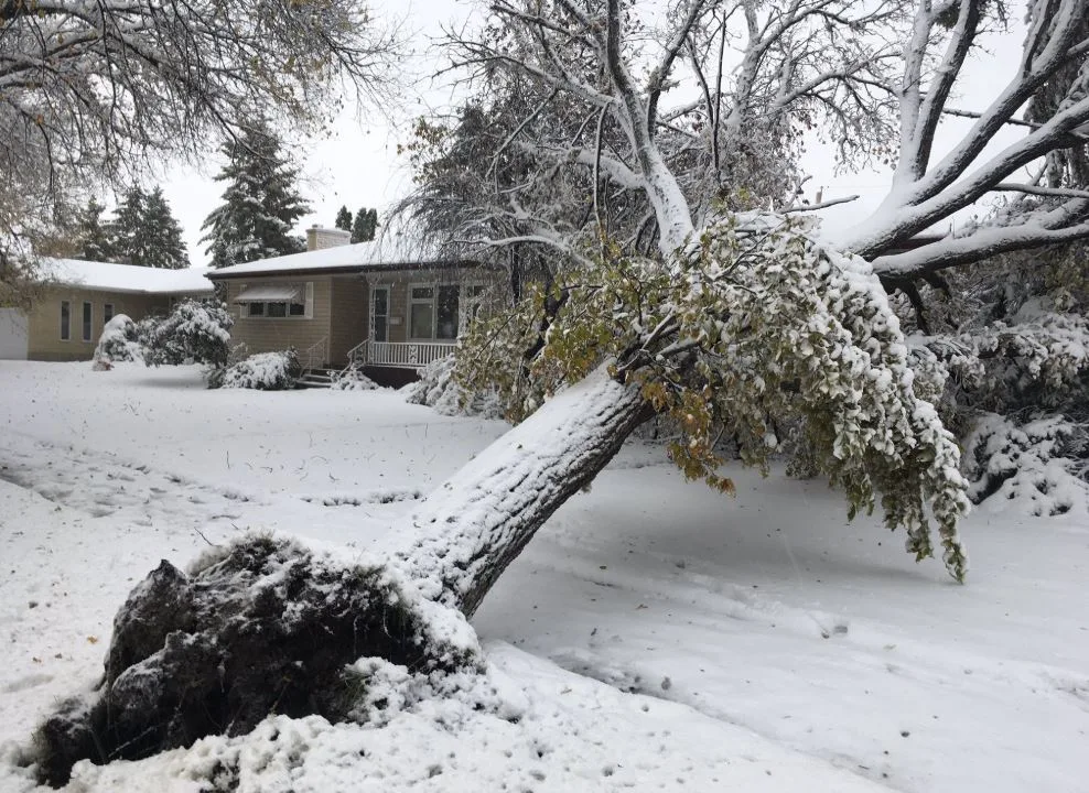
Power outages and downed trees were widely reported, with gusty winds and accumulating snow making for dangerous travel conditions and power outages.
Travel will still be very difficult by Saturday. Several major roads west of Winnipeg, including the Trans-Canada Highway, were closed outright Friday evening, with still others reported as partially or fully covered with snow.
WATCH BELOW: MOST CANADIAN THING TO DO WHEN STUCK IN A SNOW-CAUSED ROAD CLOSURE

The greatest snow accumulations will likely be between the North Dakota border and Highway 1, between Brandon and Portage la Prairie where 50+ cm is possible through Saturday.
Areas closer to the Red River, including the city of Winnipeg, could also get between 10-25 cm of wet snow. Accumulations of 20-30 cm will extend westward into Saskatchewan and slowly diminish to zero in Regina.

"Through Saturday, snowfall intensity will be a little lighter, but still ongoing, mainly west of Winnipeg," Weather Network meteorologist Nadine Hinds-Powell. "Through Sunday and Monday, conditions will be much improved, with widely scattered wrap-around light rain/snow mix as the low continues to weaken into northwestern Ontario."
Strong winds will also continue through Saturday, gusting in the 40-60 km/h range Saturday. This may result in lingering blizzard-like conditions south of Lake Manitoba and along the Trans-Canada Highway.
THOUSANDS WITHOUT POWER AS HEAVY, WET SNOW TAKES DOWN TREES AND POWERLINES
Despite ongoing efforts by Manitoba Hydro, the number of customers without power was up and down Friday. By 7 p.m. Friday night, Manitoba Hydro reported almost 50,000 customers were in the dark with roughly 14,000 outages in Winnipeg alone. That's as wet snow and gusty winds take a toll on tree branches and powerlines.
"If you see a damaged or fallen power line, stay away and call 911," Manitoba Hydro tweeted on Thursday. "Treat all lines as energized. Stay away from them or anything they touch."
WATCH BELOW: POWER LINES FLASH IN MANITOBA
HEAVY RAIN, STRONG WINDS IN SOUTHEASTERN MANITOBA, NORTHWESTERN ONTARIO
If the snow wasn't enough, east of Winnipeg and across northwestern Ontario, heavy rain will be the concern with the same system. That's as a mild southeast flow on the east side of the low will keep the region above freezing through the weekend.
"The heaviest rain will be through Lake of Woods where 50-70 mm is expected by Saturday, meanwhile less than 20 mm is expected east of Dryden and towards Thunder Bay, where locally higher amounts are expected along the Lake Superior shore," says Weather Network meteorologist Kevin MacKay.

Water levels on Manitoba's Red River have been rising on both sides of the Canada and U.S. border and are now higher than they have been since record keeping began back in 1971. For the first time ever in the fall season, the Red River Floodway has been put into use with the heavy rainfall amounts expected through the weekend.
WATCH BELOW: WINNIPEG MAYOR SAYS OPENING THE FLOODWAY IN FALL IS 'UNPRECEDENTED'
Stay tuned to The Weather Network online, on TV and on social media for the latest updates on the storm.