
Heavy rain, flood risk continue in the Maritimes through Saturday

Soaking rains will continue across the Maritimes into the first half of the weekend as a slow-moving system taps into tropical moisture
Visit The Weather Network's hurricane hub to keep up with the latest on tropical developments in Canada and around the world
Rainy conditions that began washing over the Maritimes on Friday will stick around to begin the weekend as we count the drops in a bucket that’s been filled many times over so far this summer.
It’s been an exceptionally rainy summer for much of the Maritimes. Halifax is close to measuring 200 percent of their normal rainfall since June. Normally, above-seasonal rains in the summer are attributable to tropical systems, but all of this rain fell without any tropical systems or their remnants hitting the region so far this season.
DON'T MISS: Franklin's potential Canadian impact uncertain as it heads north.
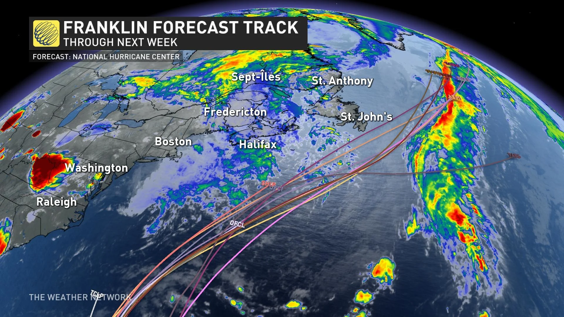
Meanwhile, forecasters continue monitoring the progress of Troipcal Storm Franklin as it slowly makes its way north for the final week of August. The system is far enough away that its eventual path is still uncertain, but the storm could track close enough to land that it could affect the Atlantic provinces next week.
Through Saturday
Areas: The Maritimes
Timing: Late Friday and Saturday
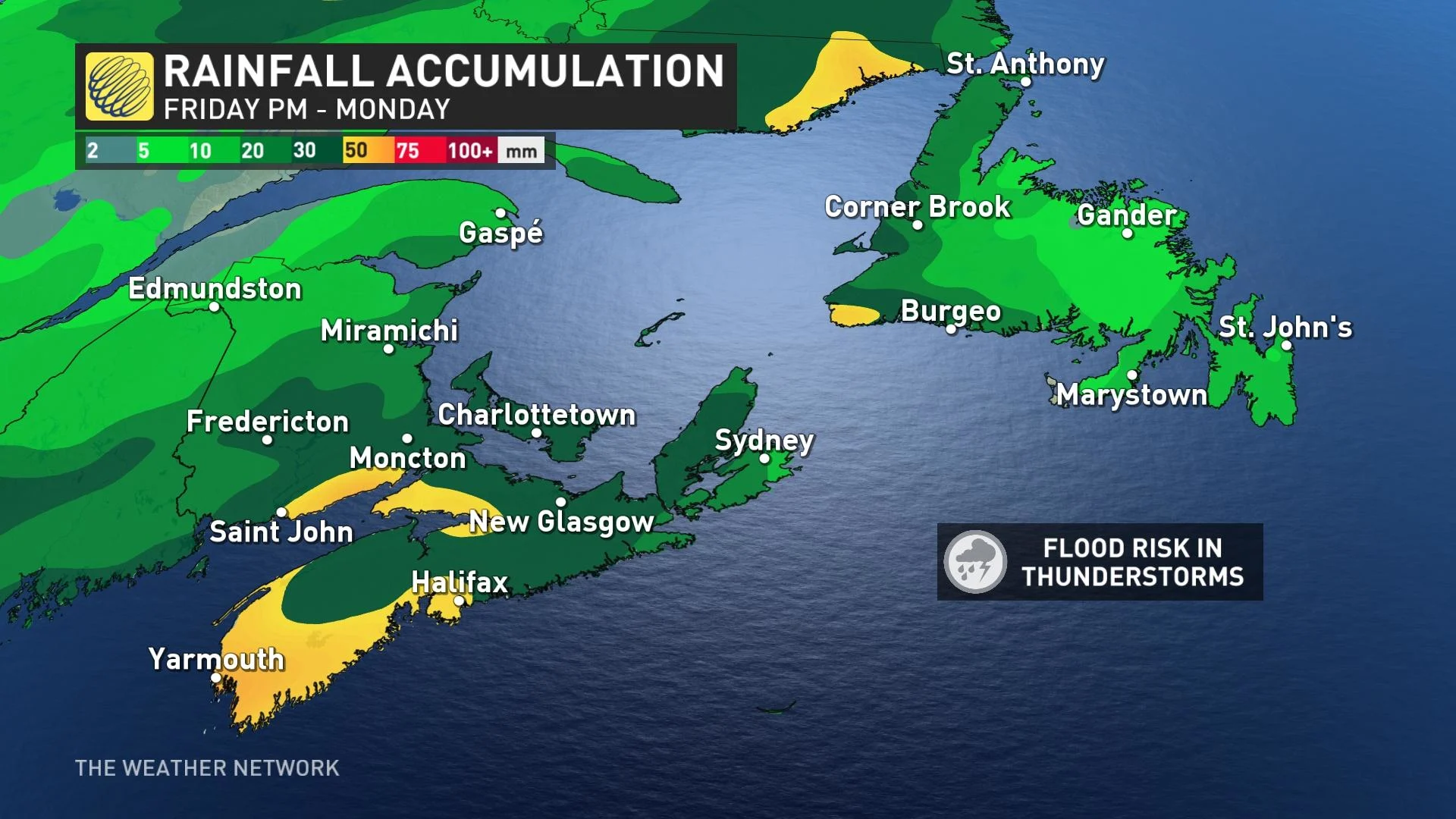
Weather: We’re on the lookout for an additional 40-60 mm of rain for portions of the Maritimes through this weekend.
A low-pressure system pushing into the region will bring heavy rains and possibly a few rumbles of thunder. We’ll see rain begin late on Friday and continue into Saturday for most.
Saturday will see the potential for some embedded thunderstorms with the widespread rain moving through the area. The risk of flooding increases with the threat of thunderstorms as heavy downpours and the risk of training thunderstorms could occur. The main risks with thunderstorms are strong winds, localized flooding, and small hail.
Rainfall totals of 40-60 mm are possible throughout the region, especially in Nova Scotia, eastern Prince Edward Island, and coastal portions of New Brunswick. Elsewhere, general totals of 20-40 mm are possible.
DON'T MISS: Watch? Warning? How we communicate severe weather in Canada

All eyes on Tropical Storm Franklin
Tropical Storm Franklin is slowly gathering steam in the western Atlantic Ocean.
MUST SEE: East Coast on guard as Franklin is on track to become a hurricane
Forecasters expect Franklin to grow into a hurricane as it slowly moves north through the western Atlantic, heading in the general direction of Atlantic Canada. However, a complicated pattern over the Atlantic will ultimately guide its path, leading to high uncertainty in its exact path and strength. Keep a close watch on the system through the week for potential impacts on the region.
Prepare
Make sure to keep up-to-date on your local forecast information and alerts. If you are outdoors in an area with a severe weather threat, make sure you have a safety plan in place in case you need to get to shelter.
Use extreme caution in areas that may experience localized flooding during and after heavy rains. Never try to drive across a flooded roadway. It’s impossible to tell how deep the water is until it’s too late, and the road may have been washed out beneath the water. It only takes a small amount of water for a vehicle to lose traction and begin floating, endangering both the lives of the occupants and their rescuers.
Header image courtesy of Getty.
Be sure to check back for the latest on conditions across the Maritimes.