Upwards of 100 mm of rain could soak parts of B.C. as wet pattern returns
The calm break in soggy conditions B.C. has recently enjoyed will be in the rearview mirror by Sunday as an active pattern returns to the West Coast.
B.C. will welcome in another stretch of soggy rains and heavy alpine snow for the second half of this weekend.
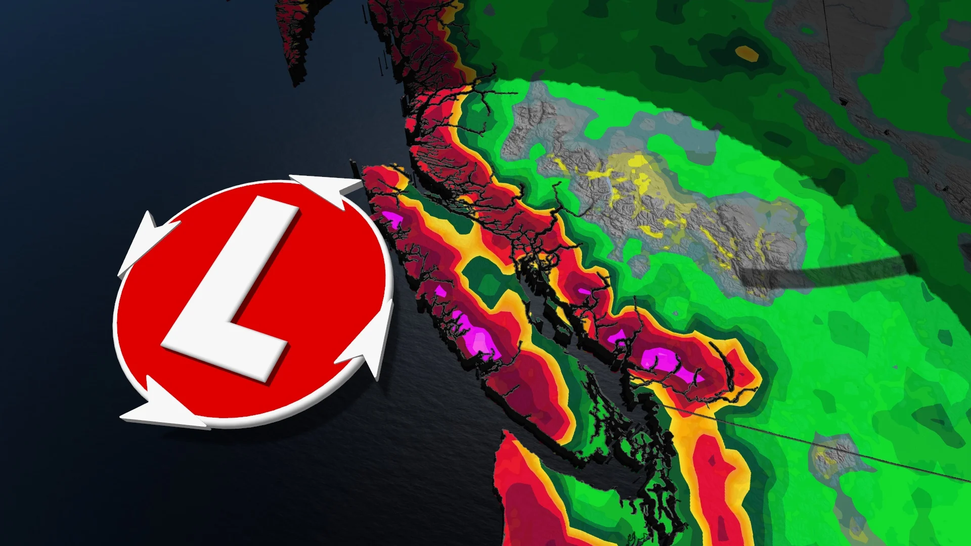
Several waves of precipitation will bring widespread totals of 50-100+ mm of rain across southwestern portions of the province. Meanwhile, some of the higher elevations could see 30-75 cm of snowfall.
DON’T MISS: The threat of earthquakes is very real in Canada: Are you prepared?
While none of the inbound systems are expected to be major, the parade of lows will bring above-normal precipitation totals to the South Coast region for the next couple of weeks.
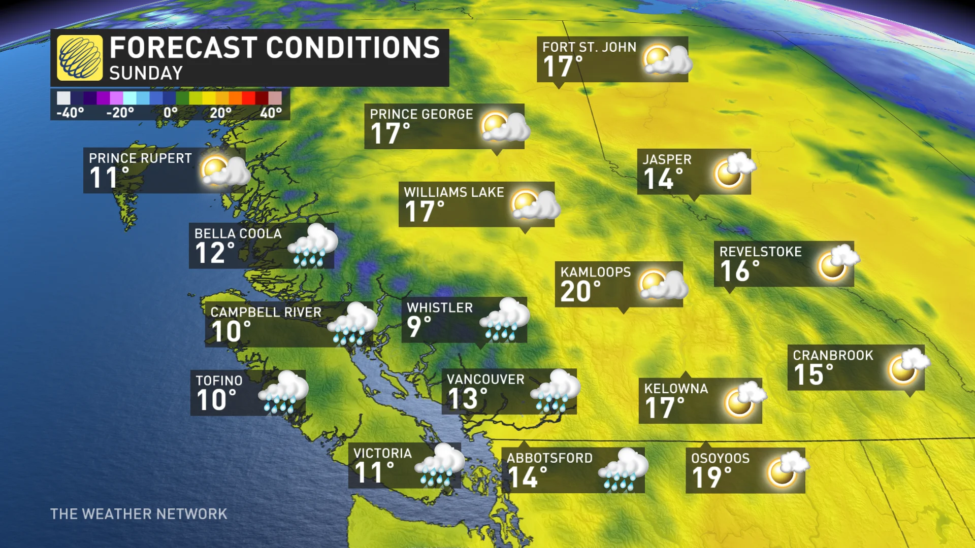
Mild conditions for the Interior, but rain makes a comeback
The weekend will see very mild conditions in the Interior, with temperatures near 20°C for daytime highs Saturday and Sunday. We’re looking at the chance of the first 20°C of the year this weekend for the Kamloops and Thompson-Nicola areas.
The centres of high pressure that kept the storm track at bay will wane through the weekend, allowing the activity to build back into B.C. by Sunday.
We’ll see a rainy front drape across the coast by early Sunday morning, with the active pattern holding on for several days into next week.
Expect a parade of storms with persistent rains across Vancouver Island and the Lower Mainland. Each individual wave of rain won’t be noteworthy on its own, but the cumulative rain from each event will add up by next week.

Rainfall totals on the order of 50-100 mm are possible for Tofino and the North Shore Mountains. Falling temperatures will push freezing levels from 1,500 metres to 1,000 metres between Sunday and Tuesday, which could allow 30-50 cm of snow to fall in elevations above 1,000 m. Beware the risk for an unstable snowpack throughout the region. Locations sitting above 1,800 metres could accumulate 50-75 cm of snow.
All the rain of late isn’t necessarily a bad thing. Rain in the spring is usually good news heading into the upcoming wildfire season.

It isn't just an abundant amount of rainfall the South Coast has seen lately. The alpine areas have seen a notable increase in snowpack.
Between March 15 and April 1, significant snowpack growth occurred in:
Lower Fraser: +17 percentage points South Coast: +12 percentage points Vancouver Island: +9 percentage points

No major storms are expected in the longer term, but a series of systems will bring above-normal precipitation totals to the south region for the next couple of weeks.
Changeable temperatures are expected over the next two weeks with a few warmer days, but overall, temperatures will end up on the chilly side of seasonal except for northeastern B.C.