'Dramatically improved' chances for a White Christmas for millions

Winter has officially begun, aligning perfectly with the week and final days leading up to Christmas. As the countdowns continue and the holiday excitement builds, more people may be wondering if there's a chance they'll wake up on Christmas morning to a coating of snow outdoors.
A white Christmas can be magical, but despite Canada's northern location, the chances of one are very hit-and-miss across the country, and location dependant. Parts of the west and northern Ontario, for example, are historically almost guaranteed a White Christmas, while the odds are much slimmer for B.C.'s South Coast and the Greater Toronto Area.
A late December storm system tracking from coast-to-coast has shaken up the map a bit for our Holiday Snow Report however, improving the chances of a White Christmas for many, but leaving some regions still grappling with uncertainty as the holiday forecast comes down to the wire.
Here's how we think Canada's 2020 holiday snow chances will pan out.
Visit our Complete Guide to Winter 2021 for an in depth look at the Winter Forecast, Canada's ski season, and tips to plan for everything ahead!
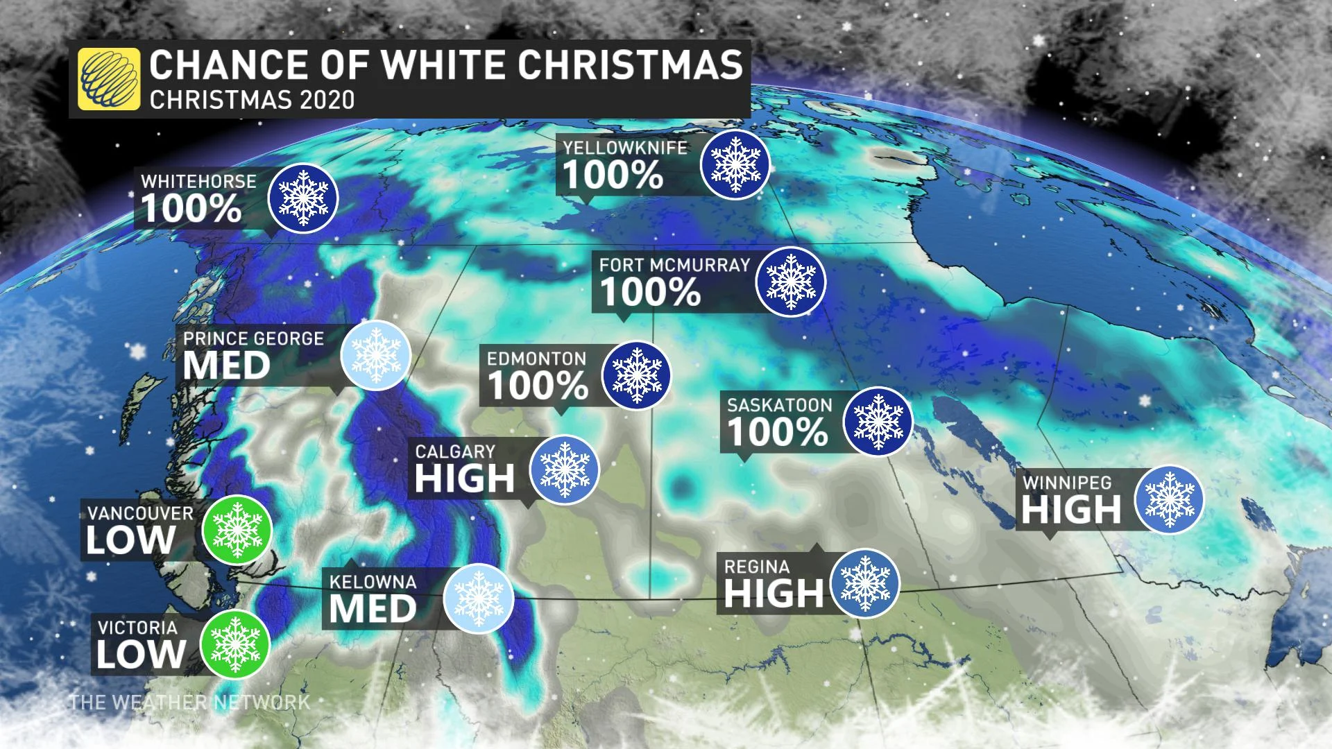
BRITISH COLUMBIA
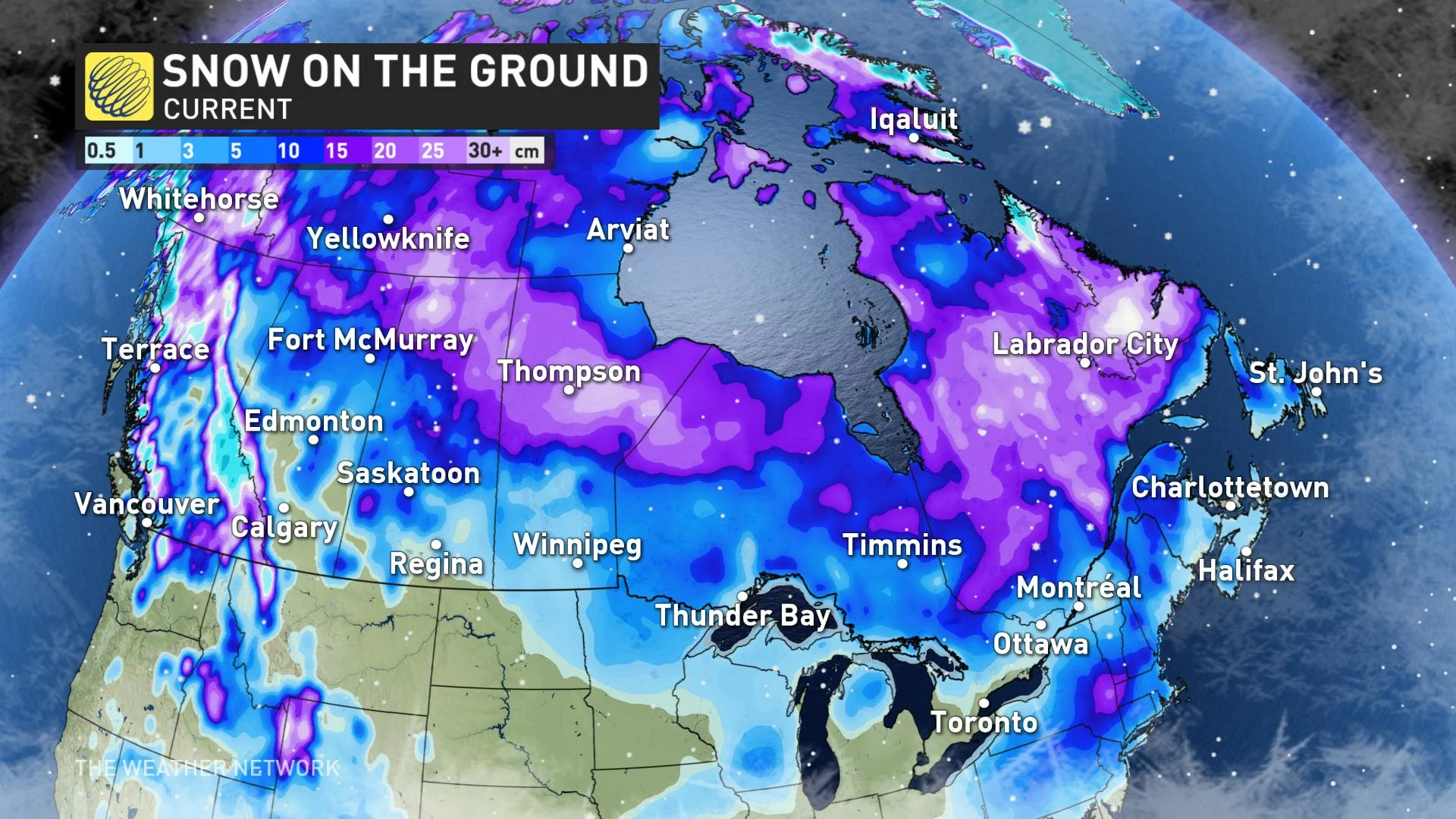
A moisture-laden Pacific storm early this week will add to an already substantial base of snow in the mountains of B.C, locking in a White Christmas for the higher elevations.
The system will also bring some accumulations to the interior valleys, though temperatures there will be closer to the freezing mark. A White vs Green holiday for places like Kelowna will depend on both how much snow you get from this week’s system, and how much snow cover you can hold on to through the week, leaving chances at Medium for now.
For the South Coast including Metro Vancouver and Victoria, we can’t rule out some flakes early in the week as the system treks through, but a mild finish to the week will keep Christmas green for areas near sea level.
PRAIRIES
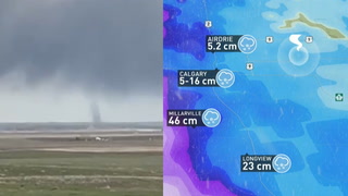
A swath of timely snow, thanks to a potent clipper system, has dramatically improved chances for a White Christmas in the southern Prairies. Places like Calgary, Regina, and Winnipeg are likely to pick up substantial fresh accumulations this week, including some areas where snow cover had previously been scarce.
The northern Prairies already have abundant snow cover thanks to an active storm track, and the presence of arctic air this week will keep this region white for Christmas as usual.
SOUTHERN ONTARIO
Southern Ontario has seen bouts of snow this year, but an overall mild pattern has kept it from sticking around for long. Chances of a White Christmas are slim this year, but we do have a very amplified jet stream pattern and an active storm track set to impact the region over the Christmas holiday.
This storm will likely bring rain for most, but a blast of arctic air could lead to a late changeover to snow as the system departs. Though the chances of 2 cm on the ground Christmas morning are low, we could see periods of snow in the air along with very cold temperatures for Christmas and Boxing Day.
NORTHERN ONTARIO
Much of Northern Ontario already has plenty of snow in place, and this week’s system will bring even more. No worries about a green Christmas here.
QUEBEC AND EASTERN ONTARIO
A White Christmas in this region will also come down to the impacts of our Christmas-time storm system. A mild pattern has erased the existing snow cover, but it’s still possible that our late week storm could bring a few centimeters just in time for the holiday.
This region will come down to a photo finish, with a coating of snow likely Christmas Eve and into Christmas morning. Parts of the region have the potential for more substantial snow totals, but it is too early to pinpoint where that heavier snow will fall.
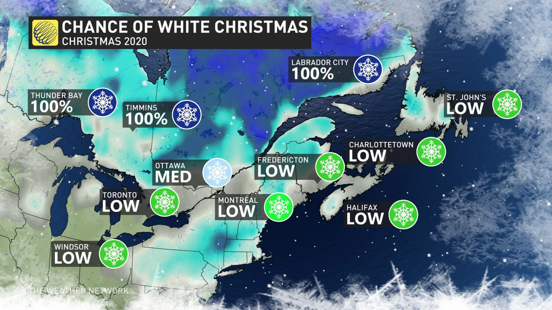
ATLANTIC CANADA
Atlantic Canada has seen several rounds of wintry storms so far this season, but surges of milder air have kept persistent snow cover to a minimum. An active storm track will continue for the Atlantic coast, with rounds of precipitation, mainly in the form of rain.
A surge of milder temperatures in advance of our Christmas weekend system will help lock in a green Christmas for most of this region.
THE TERRITORIES
No concerns across this region, as abundant snow and Arctic air will make a white Christmas a lock for the territories, as usual.
Be sure to check back regularly as we continue to finetune the forecast!