Atmospheric river brings slog of heavy rain to B.C., risks flood in
December is starting off on a soggy note across B.C.’s South Coast, where more than 100 mm of rain is possible, as well as freezing rain amid other threats
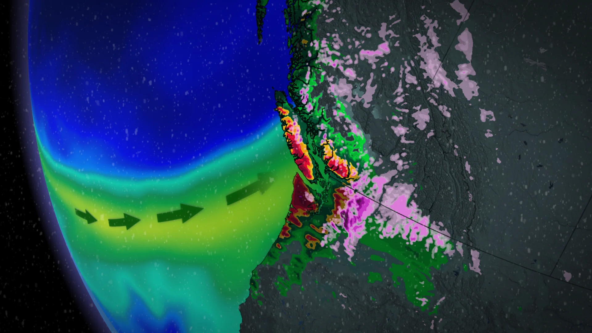
Get ready for a Monday soaker across most of Vancouver Island and the South Coast as a potent atmospheric river washes over British Columbia to begin the week.
While the atmospheric river is only rated between AR1 to AR2, heavy rainfall rates and soaring freezing levels will combine to produce a localized flood threat for many areas, and an avalanche risk will exist in the alpine regions as warm temperatures and the rain destabilize the fresh snowpack.
WINTER 2024: El Niño will play a critical role in the weeks ahead

Atmospheric river brings heavy rain Monday through Tuesday
Rain that began on the weekend will crank up in earnest on Monday as a classic Pineapple Express splashes into the coast.
A Pineapple Express is an atmospheric river that transports tropical moisture straight from the Hawaiian islands, providing a vast reservoir of moisture aloft to fuel heavy rains and tremendous snows along the mountain peaks.

Expect the heaviest rainfall to arrive in B.C. during the afternoon and evening hours on Monday, accompanied by mild air that will fluctuate freezing levels and send them soaring nearly 3000 metres above sea level. Rainfall rates will reach 10-15 mm per hour at times along the South Coast Monday afternoon and evening.
This sustained slog of heavy rain will lead to hefty totals across the region.

By Monday evening, travel delays may impact B.C. residences. Ferry delays are possible near Victoria and Vancouver, where winds are forecast to increase over 50 km per hour in the straits during the evening commute hours. Changeable highway pass conditions are expected too, with primarily rain for those further west, but freezing precipitation for those north and east.
Overnight Monday, into Tuesday morning, rainfall may fall but should freeze on contact as the chillier air holds in the Interior. Freezing rain and drizzle environments may last several hours, especially for the southern Kooteneys. How much ice builds up is uncertain as freezing levels begin to lower back to near 1200 metres on Tuesday.
WATCH: Elevated flood risk for Vancouver courtesy of an atmospheric river
Freezing rain, flooding, and landslides all on the table
Most of western Vancouver Island is on track to see more than 100 mm of rain through Tuesday, with the highest totals falling near Tofino. Far less rain is expected on the eastern side of Vancouver Island due to the rain-shadow effect, with just 10-20 mm on the way for the Victoria area.

Totals of 75-100 mm are expected along the South Coast from the northern Vancouver metro toward the Sea to Sky. Lower totals are in the forecast for the southern Lower Mainland, ranging from 30-50 mm in Tsawwassen to 50-75 mm closer to Abbotsford.
A localized flooding threat could develop with this much rain falling in such a short period of time. Look out for flooding and landslides across the higher terrain around the South Coast, with the exception of downtown Victoria.

Folks across the region should diligently check avalanche ratings and take appropriate safety measures, staying on top of the ever-present avalanche risk across the province’s terrain. The avalanche danger has risen to high as a result of melting snowpack for the North Shore and Vancouver Island mountain ranges.
Due to the snowmelt potential heading into early next week, these regions will also need to watch the potential for rising waters in the days ahead.
Stay with The Weather Network for the latest on conditions across B.C.