Déjà vu: Similar March storm setup in Ontario with messy outcome

Another battle of the seasons looms in Ontario as a low-pressure system tracks in mid-week with a messy mix of precipitation.
Contrary to the popular lore, March will not be going out like a lamb in southern Ontario. It will be quite the contrary, with the month heading out like a lion thanks to a storm setup that mirrors a system from Wednesday, March 23. Like the previous week's system, a messy outcome is anticipated across the province. The storm will bring heavy snow, freezing rain, ice pellets, rain, blustery winds and warmer temperatures, however brief, depending on locations. Expect travel impacts Wednesday and Thursday. More on the timing and impacts on the impending storm, below.
MUST SEE: Canada, we're stuck in a weather time warp. Here's why
WEDNESDAY/THURSDAY: ANOTHER MID-WEEK STORM THREATENS HEAVY SNOW AND FREEZING RAIN
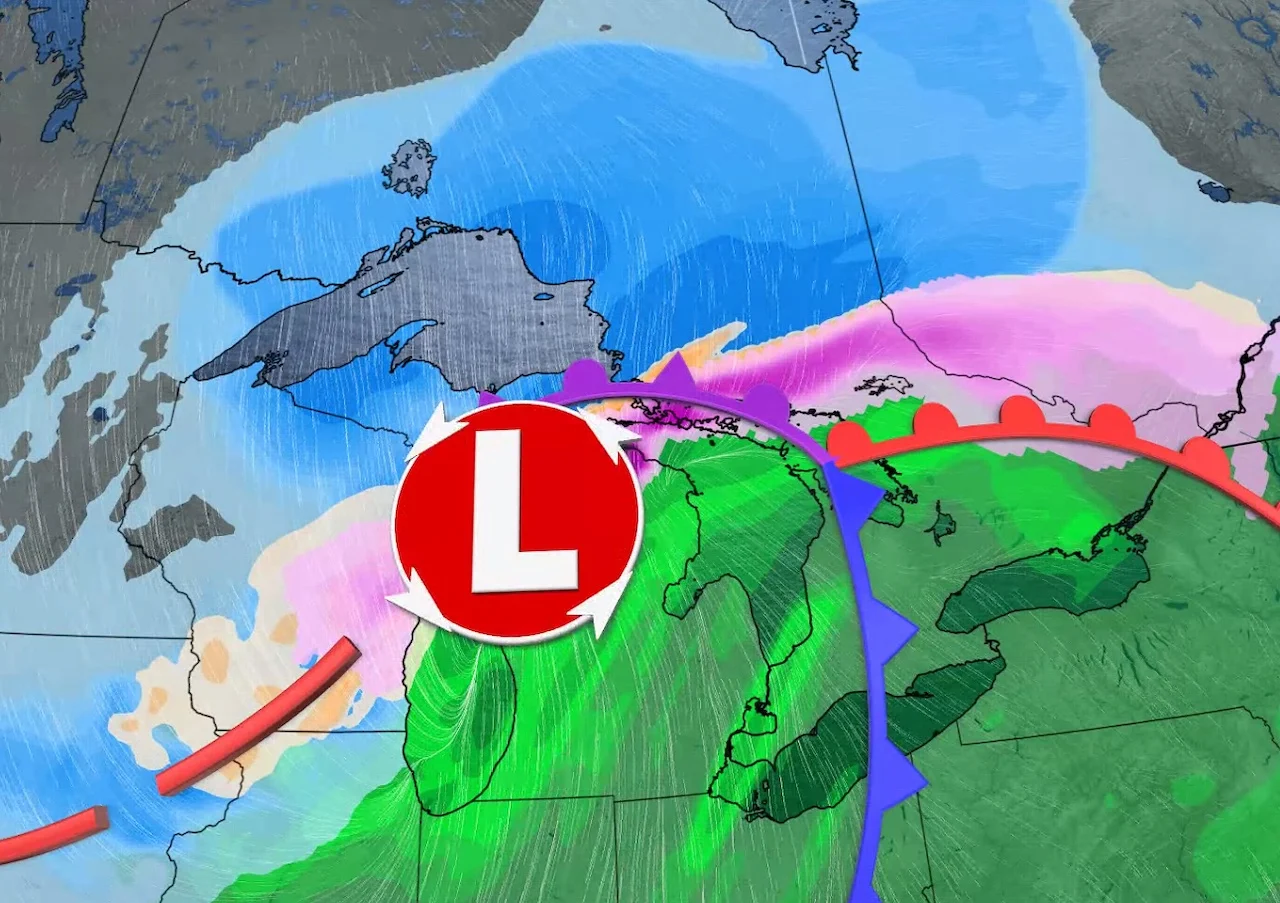
A broad trough will slowly shift east, with a mid-week storm accompanying a strong jet stream in Central Canada.
Temperatures will warm up gradually starting Tuesday, with a brief warm-up mid-week, but chilly conditions will persist into the beginning of April, with no sustained warm weather in sight.
PHOTOS: Rude wake-up call: Ontario sees impressive spring lake-effect setup

Forecasters are also eyeing a low-pressure system that will track into the region on Wednesday, as March goes out like a lion instead of a lamb. In fact, the setup has some resemblance to the storm that hit Ontario on Wednesday, March 23. Widespread special weather statements are in effect for northern, central and parts of eastern Ontario.
The storm track favours rainfall and a brief warm-up across southern Ontario, but at this point it looks like freezing rain will impact many of the same regions that saw the ice accretion last Wednesday. Meanwhile, heavy snow will target northern Ontario once again but Thunder Bay looks to have escaped the worst of it this time around.

"There will be a lull in the system for southern Ontario between the warm front and cold front. So Wednesday overnight through Thursday afternoon, the cold front will move through bringing rain, as well as some warmth," says Matt Grinter, a meteorologist at The Weather Network. "Temperatures into the teens are expected for Wednesday overnight through early Thursday afternoon, then temperatures will start to drop behind the front."
Tuesday overnight will see snow push into northern Ontario while freezing rain and ice pellets inch into southwestern sections. It will crawl into the rest of the south by early Wednesday morning, including the Greater Toronto Area, spreading into cottage country and eastern sections as the day progresses.

As temperatures warm up in the south Wednesday morning, precipitation will change to rain in southern Ontario.
For parts of northern, central and eastern areas, significant freezing rain with ice accretion is possible Wednesday overnight into early Thursday morning. However, at this time there remains considerable uncertainty regarding the amount of snow, ice pellets and freezing rain. A freezing rain warning may be needed as the system approaches.
The heaviest snow will be northeast of Lake Superior with a large swath of 20-40 cm possible, while 10-20 cm is earmarked for areas east of the lake.
Considerable travel interruptions should be anticipated across the province Wednesday and Thursday.
Welcome to spring, Ontario!
Be sure to check back for the latest updates on the changing conditions across Ontario.
Subscribe to 'This Day in Weather History': Apple Podcasts | Amazon Alexa | Google Assistant | Spotify | Google Podcasts | iHeartRadio | Overcast