
Gloomy end to April in Ontario, but there is a silver lining in the clouds

A dreary stretch of weather in Ontario will boil over on Sunday and Monday as gusty winds, rumbles of thunder, and possibly shattered weather records are in the forecast
The stretch of dull, wet weather continues across Ontario as a sluggish pattern keeps the clouds and bouts of precipitation locked over the province.
We’re looking at the potential for a record-breaking system to develop heading into the new work week. This storm could produce the lowest air-pressure readings some parts of Ontario and Quebec have ever seen in the month of May.
DON’T MISS: Record-breaking low pressure set to swirl across Eastern Canada

This bout of late-April gloom sprawled over Ontario is the result of several upper-level lows meeting up with a rich plume of Gulf moisture surging in from the South -- an atmospheric combo ripe for persistent clouds and heavy rainfall.
Rainfall warnings are in effect in parts of cottage country and southeastern Ontario, advising residents of the potential for 50+ mm of rain by Monday morning. Special weather statements span the rest of eastern Ontario, extending into northeastern sections of the province.
WATCH: Did your Canadian city make the list of worst springs?
Most areas from the GTA to the Nickel Belt can expect to see around 30-50 mm of precipitation. Expect ponding on roads and localized flooding in low-lying areas, particularly in the hardest-hit regions.
We’re on track to witness a bit of local weather history as this pattern plays out. A developing low-pressure system tracking toward the Ontario/Quebec border could grow so strong that it threatens to break multiple long-standing air pressure records for the month of May.
Some cities, including Ottawa, expect predicted air pressure readings that are “highly unusual for May in the Great Lakes region,” according to Tyler Hamilton, a meteorologist for The Weather Network. Some indications highlight the lowest pressure could be below 980 hPa, an easy record for the City of Ottawa for May.
Don’t be surprised to hear a couple rumbles of thunder amid the rain in eastern Ontario on Sunday night as this system gears up.
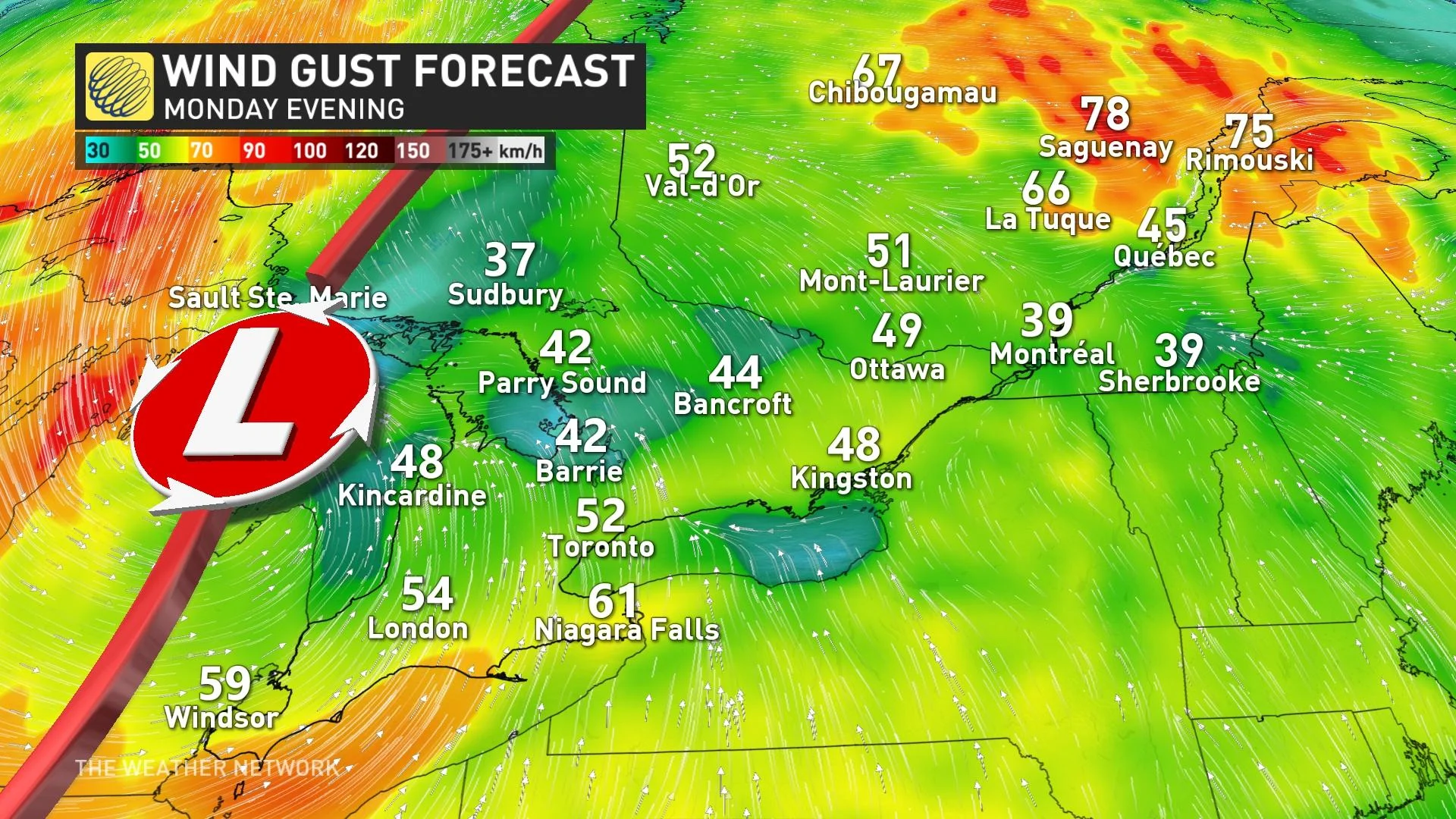
Scattered power outages are also possible as gusty winds buffet southern and eastern sections of Ontario Sunday night and into the day Monday.
This rain will tip April’s monthly precipitation totals above average by the time May 1 rolls around.
MUST SEE: All the rain gear you need to stay as dry as possible this spring
However, there is a silver lining in the clouds, or a dim light that is. Complete sunshine is anticipated to emerge by Wednesday.
This kind of pattern will force temperatures to fall on the cooler side of seasonal through the weekend. It’ll be so cool up north, in fact, that some folks in northern Ontario can expect snow this weekend.
The heaviest snowfall totals that will stick will be confined to remote regions in northern Ontario. Locally 10-20 cm is possible north of Lake Superior. Travel along portions of the Trans-Canada Highway will be difficult during the heavy snow.

A wintry mix is even possible across southern Ontario’s traditional snowbelt regions on Monday night.
Calmer days are on the horizon. Gloomy conditions will start to break up by the middle of this week, likely revealing more sun than clouds as we head toward the first full weekend of May. We're looking ahead to the potential for a period of warmer and drier conditions to arrive in Ontario by the second week of the month.
Check back for the latest on conditions across Ontario.
Thumbnail courtesy of Rupert Britton/Unsplash.