Ocean temperatures now hotter than ever recorded. El Niño will drive them higher

“The recent ‘triple dip’ La Niña has come to an end. Now that it’s over, we are likely seeing the climate change signal coming through loud and clear.”
With ocean temperatures already setting new records, the rapid onset of a new El Niño in the months ahead could spell trouble for the world.
Following closely after the official end of the triple-dip La Niña in early March, the world’s oceans began setting new heat records on a near-daily basis. By the end of March, the average sea surface temperature (between 60°N and 60°S) climbed to above 21°C for the first time since record-keeping began. Reaching a new high of 21.1°C in the first five days of April, this beat out the previous record of 21.0°C, set back in March 2016.
“This has got scientists scratching their heads,” Michael Meredith, an oceanographer and Science Leader at the British Antarctic Survey, told The Guardian. “The fact that it is warming as much as it has been is a real surprise, and very concerning. It could be a short-lived extreme high, or it could be the start of something much more serious.”
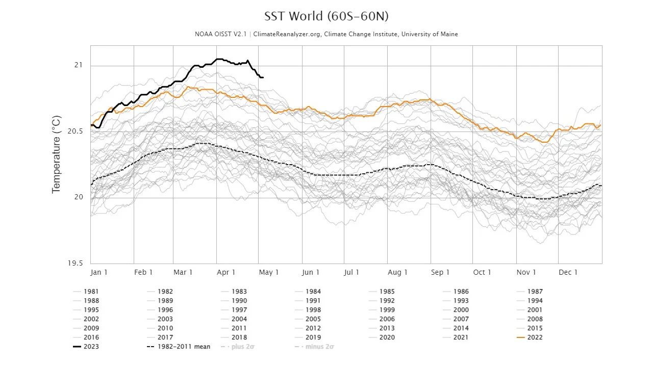
Daily sea surface temperatures are plotted here from 1981-2023, with 2022 in dark orange and the heavy black line representing 2023 so far. Each year, ocean temperatures follow a pattern based on the combined seasonal changes in the northern and southern hemisphere. They typically reach a maximum during NH Spring/SH Fall, and then a second peak in NH Fall/SH Spring. (Birkel, S.D. 'Daily Sea Surface Temperature', Climate Reanalyzer, Climate Change Institute, University of Maine, USA. Accessed on May 5, 2023.)
READ MORE: Temperatures in 2023 could be record breaking with rapidly developing El Niño
These extreme ocean temperatures are particularly remarkable due to the fact that we just got out of a three-year repeating La Niña pattern.
“The recent ‘triple dip’ La Niña has come to an end. This prolonged period of cold was tamping down global mean surface temperatures despite the rise of greenhouse gases in the atmosphere,” Michael McPhaden, NOAA's director of the Global Tropical Moored Buoy Array Program, told The Guardian back in early April. “Now that it’s over, we are likely seeing the climate change signal coming through loud and clear.”
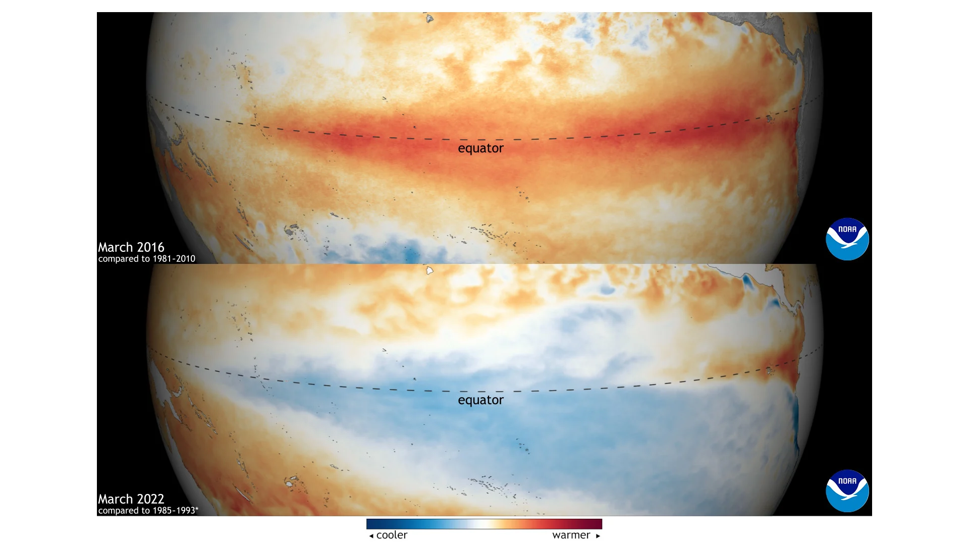
Sea surface temperature anomalies across the equatorial Pacific Ocean are compared here from March 2016 (top) to March 2022 (bottom). March 2016 saw the peak of one of the strongest El Niño patterns on record, which resulted in warmer than normal temperatures across the ocean. In March 2022, we were in the midst of an extended pattern of La Niña, the cool phase of the El Niño Southern Oscillation (ENSO). (NOAA/Climate.gov)
The influence of La Niña over the past three years kept ocean temperatures cool enough that the yearly maximums did not exceed the 2016 record. Notably, though, overall ocean temperatures for 2020, 2021, and 2022 still ranked among the hottest on record. That reveals just how much extra heat has been added to the oceans due to human activities — such as deforestation and burning fossil fuels — in recent years.
Early 2023 sea surface temperatures are now hotter than anything we’ve seen in the previous 42 years. If the current ‘ENSO-neutral’ conditions continue, the oceans are warm enough that more daily heat records will likely be broken throughout the rest of the year. In that case, we could see ocean temperatures spike above 21°C again in early 2024.
SEE ALSO: A ‘vicious cycle’ — green active transportation gets harder with climate change
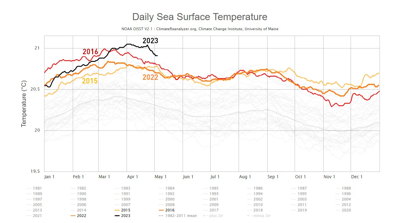
This graph highlights daily sea surface temperatures from the years of the last El Niño, 2015 and 2016, showing them in yellow and red, respectively. 2022 is in dark orange, and the thick black line represents 2023, so far. (Weather Network graph. Data courtesy Birkel, S.D. 'Daily Sea Surface Temperature', Climate Reanalyzer, Climate Change Institute, University of Maine, USA. Accessed on May 5, 2023.)
However, if the ENSO forecast develops as expected — even if “only” a moderate El Niño develops — temperatures will climb even higher and set even more records.
This is not just a concern for the oceans, but also for the globe.
“ENSO has a strong relationship with the global average temperature: in general, the warmest year of any decade will be an El Niño year, and the coolest a La Niña one,” Emily Becker, the lead writer for NOAA climate.gov's ENSO Blog, said in her April update. “Global warming means that we can’t just say “El Niño years are warmer than La Niña,” since recent La Niña years (we’re looking at you, past 3 years!) have featured much higher global averages than El Niño years from the 1990s and earlier.”
“2022 was the 6th warmest year since records began in 1880, and that was with a non-stop La Niña,” Becker added. “If El Niño develops this year, it increases the odds of record-warm global temperature.”
(Thumbnail image courtesy Birkel, S.D. 'Daily Sea Surface Temperature', Climate Reanalyzer, Climate Change Institute, University of Maine, USA. Accessed on May 5, 2023.)