Melting permafrost splitting trees, threatening highways in Yukon

Many communities in Northern Canada are beginning to brace for an increased threat as temperatures warm and permafrost continues to melt.
The research has told us that Canada’s North is warming faster than the rest of the country. A 2019 study entitled Canada’s Changing Climate Report says that Northern communities, like the Yukon, are warming two times faster than the rest of the world, with territories seeing a 2.3°C increase.
This change in temperatures has had several impacts in the Yukon, including changes in amounts of rain and snow, more extreme weather events, melting glaciers and sea ice, and thawing permafrost. On a recent trip to the Yukon, The Weather Network had a chance to experience the later first hand.
It was a moment of disbelief, where you have to rub your eyes to make sure you are seeing correctly. But there right in front of us were trees split right down the middle.
“This is because of the ground moving,” Dr. Frabrice Calmels told us. He is one of the head researchers at the Yukon University’s Climate Change Research Department.
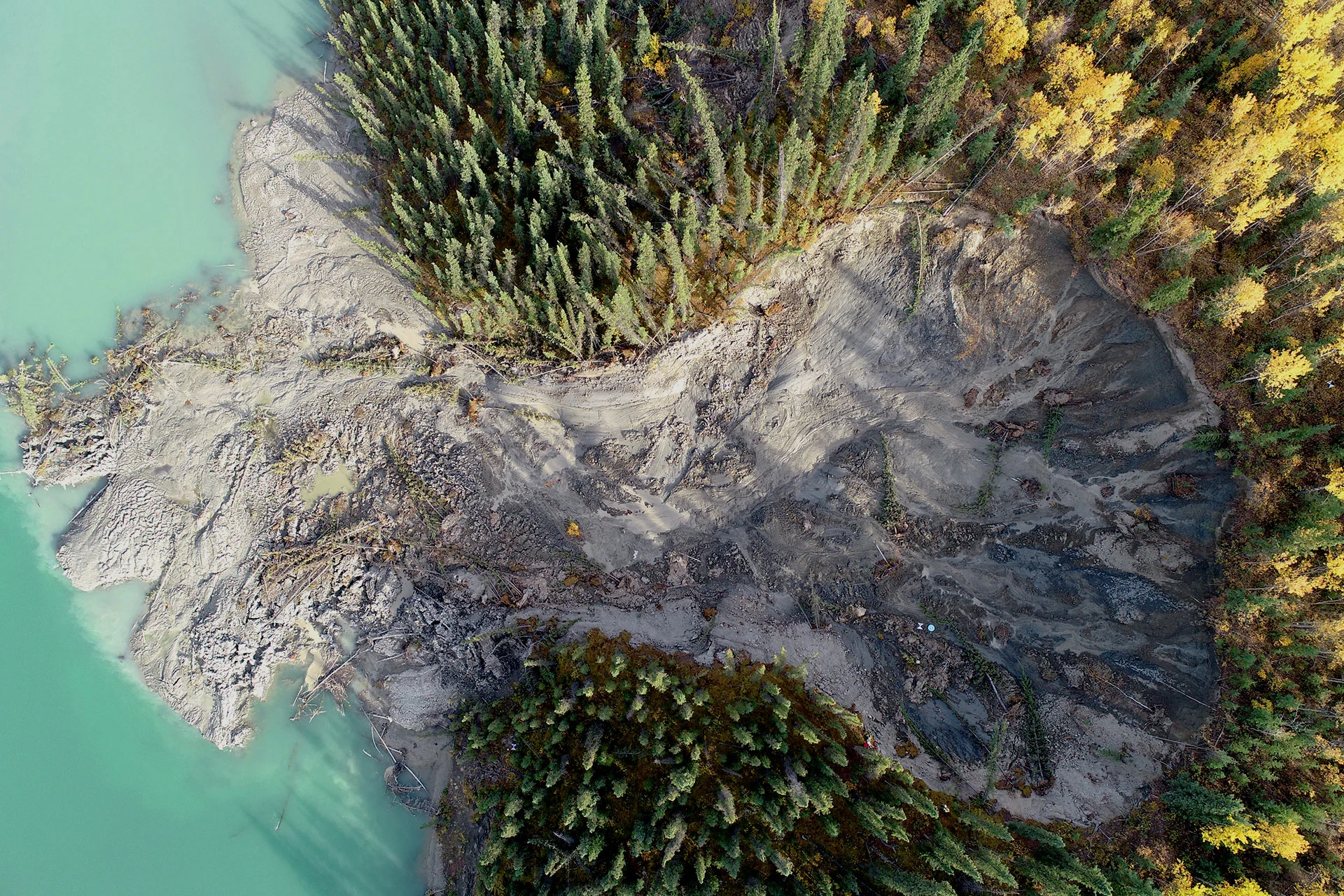
Last year, his team noticed a large thaw slump just 30 km west of Whitehorse. Tucked between the Alaska Highway and the Takhini River, the slump was caused by thawing permafrost underground. This movement of melting ice caused the ground to crack, resulting in trees bending, breaking, and eventually falling into the river below.
Drone footage shared from the university’s research department shows just how massive the slump truly is -- in just six years the melting surface has grown approximately 60 metres wide.
The most concerning aspect, and why the University has taken such interest in this particular slump, is that it is just 70 metres away from the Alaska Highway, the state’s only connection to the rest of North America.
Alaska, the Yukon, and northern British Columbia depend heavily on transportation via the Alaska Highway to connect communities with each other and with international markets. It is a crucial part of expanding economic development, ensuring a high quality of life for the people that live in these areas, and maintaining international ties. Experts say the potential impacts of melting permafrost near this highway could be devastating.
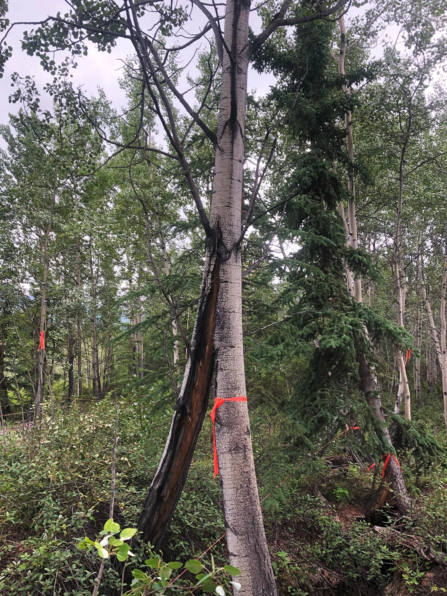
Split tree due to shifting ground caused by melting permafrost. Photo Credit: Yukon University
This is why head researcher, Dr. Fabrice Calmels, and his team are closely monitoring the slump, including indicators such as ground movement, water movement and humidity levels. Through their research they have been able to determine that there is only about five years before this slump reaches the highway, so they are being proactive.
They have been working closely with engineers and are testing different techniques that preserve permafrost. They have also been working on developing a warning system to alert nearby communities in case they aren’t able to fix the problem.
“If the landslide decides to recede and reach the road, you need a system that will record this fact and send a message to the road manager so that they can close the highway and prevent any casualties or accidents.So we are working on developing an alarm that says, hey this is happening, you should close the road,” says Calmels.
Unfortunately, this slump by the highway isn’t the only example of permafrost thawing in the Yukon.
About 50 per cent of Canada is underlain by permafrost, mainly in Nunavut, Northwest Territories, and the Yukon. Many homes, buildings, and other important infrastructure have been built on permafrost and entire communities could see the land they live on become dangerously unstable in the coming decades.
The dangers of melting permafrost are already apparent in parts of Northern Canada. In 2015, a school in Ross River, Yukon was shut down for several months because of structural concerns after teachers noticed cracks in the walls. That is when the University’s climate team (back then known as the Northern Climate ExChange) started to develop hazard maps.
Calmels tells us the maps integrate landscape hazards related to permafrost, as well as surficial geology and hydrology. They also take into consideration any potential future risks climate change could pose. The team used geoscience data to create stoplight coloured hazard maps that indicate risks including landslides and active floodplains.
Calmels says the maps work as a guideline for engineers, planners, to build safely. They are also a way to help First Nations communities adapt to the changing environment.
“We know that things are going to be bad and so we are trying to address the issue and find some remediation and adaptation strategy and we have to learn quickly because things are changing very fast.”
We can’t go back in time and stop the permafrost from thawing, but Calmels hopes he and his team can prepare Yukon communities for what the future of the territory will look like.
Top Photo Credit: Yukon University