Do not travel: Momentous blizzard threatens epic snow totals, whiteouts

What is likely to be a memorable spring storm will wallop the southern Prairies and parts of northwestern Ontario this week, with the threat for 50-75 cm of snow and dangerous blizzard conditions.
The epic, potentially historic blizzard that has been foretold for days is nearing its arrival on the eastern Prairies. Preparations for a long haul indoors should be finished as snow will move into southeastern Saskatchewan and southern Manitoba Tuesday overnight. The next two days will feature dangerous whiteout conditions, so people are strongly urged to stay off the roads -- and even beyond the storm's finish could be messy for sometime. Widespread disruptions such as road closures, power outages and school closures are likely. More on the timing and what you can expect over the coming days, below.
DON'T MISS: Red River flood risk low, but Manitoba isn't out of the woods yet
THIS WEEK: 'DO NOT PLAN TO TRAVEL-' POTENT SPRING STORM THREATENS WIDESPREAD DANGEROUS CONDITIONS, OUTAGES
A Colorado low has rapidly intensified as it nears the eastern Prairies. South of the border, it will bring the threat for blizzard conditions across the northern Plains and several days of severe thunderstorms for the southern half of the Plains and the Deep South states.
The snow will start early Tuesday evening near the international border then push northward throughout the overnight. By Wednesday morning, heavy snow will be falling in much of the area as the storm continues to push northward. Strong northerly winds will develop with this system and persist into Friday morning as the low slowly pivots through Minnesota on its way into northwestern Ontario. Snowfall rates will continue to pick up, with a few centimetres per hour possible at times.

"As the heavier snowfall band lifts north through the day Wednesday, snowfall rates may temporarily ease later in the day for southern regions, but the snowfall rates will increase once again Thursday and will be widespread across southern sections," warns Kelly Sonnenburg, a meteorologist at The Weather Network.
Intense northerly winds will develop and persist into Friday morning, as well, as the low slowly pivots through Minnesota on its way into northwestern Ontario.
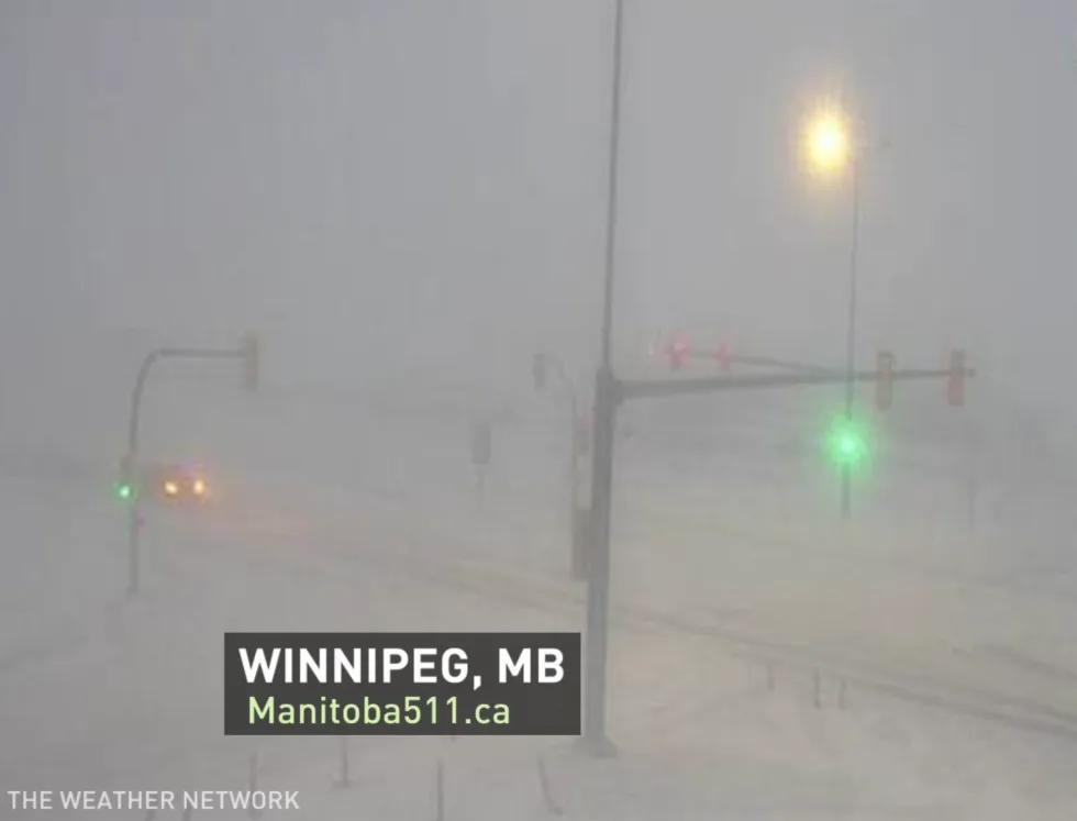
For the City of Winnipeg and points southeastward, a break in the snow may occur on Wednesday afternoon or evening before snow re-intensifies overnight into Thursday.
This is shaping up to be a high-impact, historic storm with steep snowfall totals and gusty winds that could lead to periods of whiteout conditions for many areas. Widespread inter storm warnings and blizzard warnings are in effect.

The potential for reduced visibility and whiteout conditions would significantly disrupt travel along a stretch of the Trans-Canada Highway on the Canadian side of the border as the day progresses Wednesday. Widespread highway closures are a near-certainty.
Travel will become increasingly difficult as the day progresses Wednesday, with widespread highway closures a near-certainty. By Wednesday evening, even travel within communities may become impossible as the heavy snow and strong winds continue. More of the same is expected on Thursday.
WATCH: MANITOBA BRACING FOR DANGEROUS BLIZZARD, TRAVEL NOT RECOMMENDED
"Do not plan to travel - this storm has the potential to be the worst blizzard in decades," says Environment and Climate Change Canada in the winter storm warning. "Stock up on needed supplies and medications now."
Power outages are likely and rural areas in particular should be prepared for extended outages. As well, school cancellations are also a near-certainty.

Widespread totals of 30-50 cm are possible, with a few spots possibly picking up as much as 50-75 cm of snow. However, it may be difficult to measure the exact snowfall amounts because of blowing and drifting snow. The broad scope and slow movement of this storm means that this will be a prolonged snow event, with snow lasting for up to 48 hours in some areas.
The heavy snow accompanied by northerly winds gusting 60-80 km/h, will give near zero visibility at times.
By Friday snowfall will be easing, but winds will still remain powerful with gusts of 50-70+ km/h -- and a reminder, you don't need to have snow falling to create blizzard conditions. Winds will begin to ease Friday evening.
MUST SEE: Cold temperatures should prevent major flooding after storm, experts say
On Saturday, there will still be some blustery winds at times, and by Sunday conditions will finally be much calmer.
"It looks like a favourable temperature trend beyond this system to help the flooding concerns, with daytime highs forecast to remain below freezing until at least mid next week," Sonnenburg adds.
Stay tuned to The Weather Network for all the latest on conditions across the Prairies.