‘Godzilla’ dust storm may have a connection to low Arctic sea ice

A monster dust storm stretched across the Atlantic this past summer. Its origin may have a surprising connection.
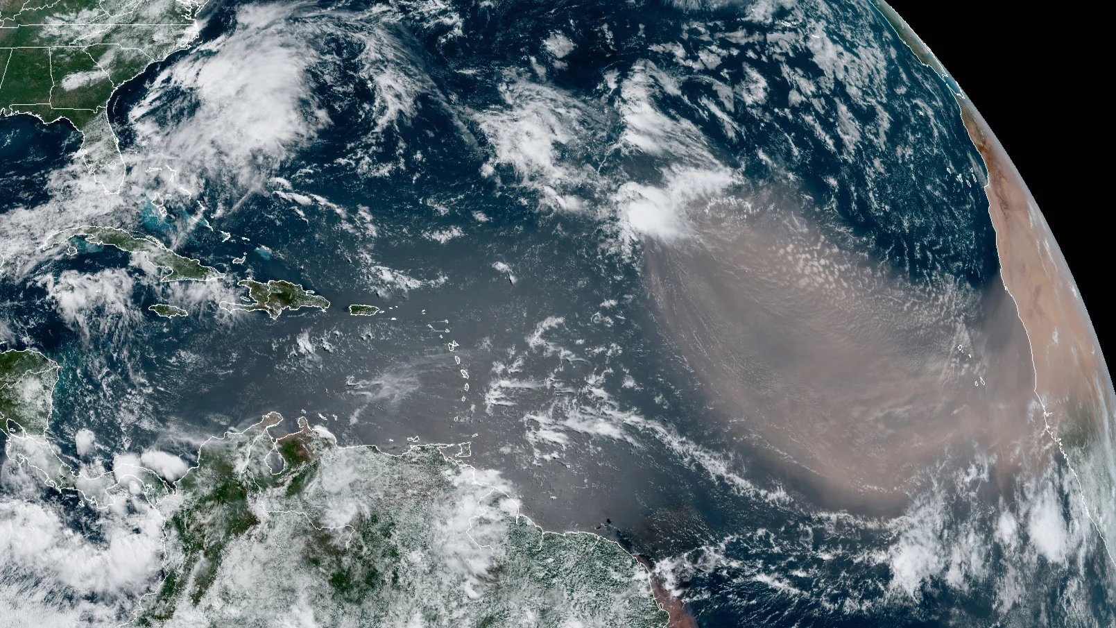
Late June of 2020 witnessed an immense dust storm crossing the Atlantic Ocean from the Sahara Desert. In cities across Central America, the Caribbean, and North Carolina to the Texas coast, skies turned dark as a thick layer of dust blotted out the Sun. In all the record books, never has a Saharan dust storm matched either the size of this one or the thickness of the dust it carried with it. As a result, some forecasters gave this extreme event the nickname 'Godzilla'.
Once the dust storm had subsided, a team of researchers led by Diana Francis of Khalifa University of Science and Technology in the United Arab Emirates set to work tracing the specific weather patterns that caused it to form.
In a new study published this week, Francis and her colleagues describe the development of what's known as a 'subtropical high' just off the coast of North Africa. Coupled with a low pressure circulation over West Africa, to the south, this set up a persistent pattern of record-strong winds that picked up dust from the desert and carried it for thousands of kilometres.
"The development of the subtropical high off the African coast had a deterministic role in both dust emissions and rapid westward transport of the airborne dust across the tropical Atlantic," Francis said in a Scripps Institution of Oceanography press release. "The clockwise circulation associated with the high, intensified the African Easterly Jet, a jet stream present over the Sahara around five kilometres in altitude, which rapidly transported the dust towards the Caribbean and southern United States."
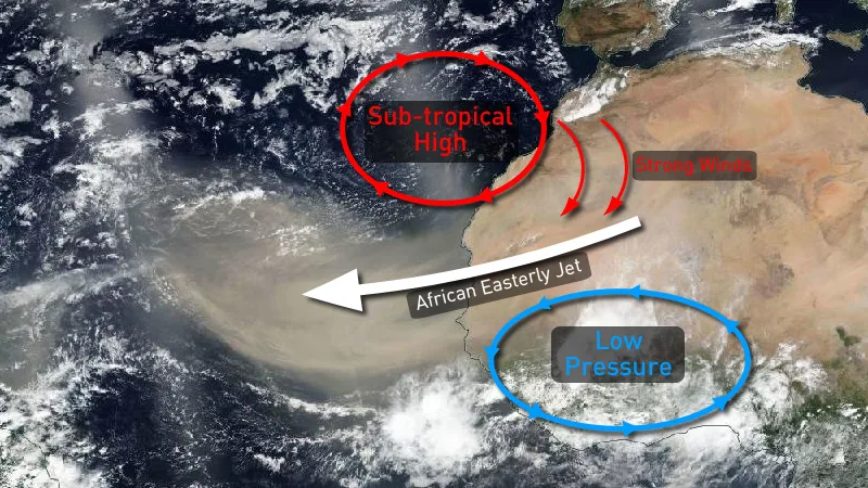
The meteorological conditions behind the intense African Easterly Jet are shown here on this satellite image from June 18, 2020, based on an image from Diana Francis. Credit: NASA Worldview/Suomi NPP/Scott Sutherland
One aspect of this that surprised the researchers was how this immense dust storm had little to no impact on the 2020 Atlantic Hurricane Season.
Saharan dust blowing over the Atlantic usually has a dampening effect on tropical cyclones. This is due to the dust scattering sunlight and thus cooling the sea surface under the plume. Despite this record large and intense dust storm persisting over the Atlantic for the latter half of June, the 2020 Hurricane Season went on to break its own records, with 30 named storms, from Arthur to Iota.
"While there is a large body of evidence suggesting that increased dust suspended over the Atlantic can reduce the numbers of tropical cyclones there, primarily through dust-induced cooling of ocean surface temperature, this year we observed the largest dust storm on record, as well as one of the most active hurricane seasons on record," coauthor Amato Evan, an atmospheric scientist at Scripps, said in the press release. "Either 2020 is just a year where everything is upside-down, or we really need to reevaluate our understanding of how dust impacts that climate system."
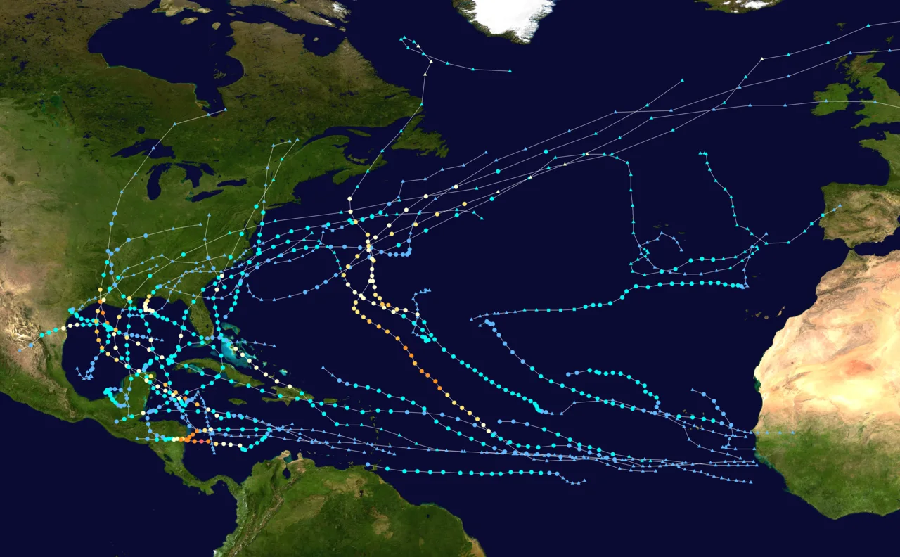
This map shows the tracks of all the storms in the record-setting 2020 Atlantic Hurricane season. Credit: WikiProject Tropical cyclones/Tracks
The study delved into one other aspect: the source of the 'wavetrain' pattern that sustained the subtropical high, and thus the dust storm. These wavetrains are deep looping patterns in the jet stream. We often see these in connection with outbreaks of the polar vortex, which spread frigid cold down across Canada and the United States. Nothing has been shown conclusively, but some research indicates a potential connection between these looping jet stream patterns and the extreme warming experienced in the Arctic due to climate change.
The strength of jet stream winds is known to be a result of the temperature difference between the Tropics and the Arctic. The colder the Arctic is, the stronger the jet stream winds are. This results in the stream blowing in a fairly tight pattern around the north pole. With the Arctic warming faster than the Tropics, however, this weakens the jet stream, allowing the pattern to relax and thus meander more.
Watch below: A weakened polar jet stream meanders in this NASA simulation
A meandering jet stream extends immense loops far to the south. This not only drags colder weather with it, but it also slows down the eastward movement of the overall pattern. Surface weather patterns, such as the subtropical high, can potentially be locked into place for sustained periods.
The Arctic is currently warming at a faster rate than anywhere else on the planet, primarily due to the losses in sea ice. When sea ice is present, it reflects sunlight back into space, preventing it from contributing to global warming. When that ice melts, the sunlight is instead absorbed by the dark ocean surface that replaces it. This warms the water, leading to more melting, which exposes more water. In essence, it is a climate feedback loop.
In their study, Francis and her colleagues note that the dust storm, which was sustained by one of these looping jet stream patterns, coincided with near record lows in Arctic sea ice. While they draw no specific conclusions, they suggest that if such a connection exists, we may see more of these Godzilla dust storms in years to come.
"As the Arctic sea-ice cover was rather low in June 2020, around the lowest on record in the period of satellite observations, it may have contributed to the observed large-scale anomaly pattern," they wrote in the study. "Thus, if such patterns become more common in a warmer world, it is plausible that these extreme dust outbreaks will increase in frequency in the future."